Շաքիի ջրվեժ (Shaki Waterfall) – A Hidden Gem in Syunik, Armenia
Discover the 18‑meter cascade tucked away in the rugged beauty of southern Armenia. Perfect for nature lovers, photographers, and off‑the‑beaten‑path travelers.
1. Introduction
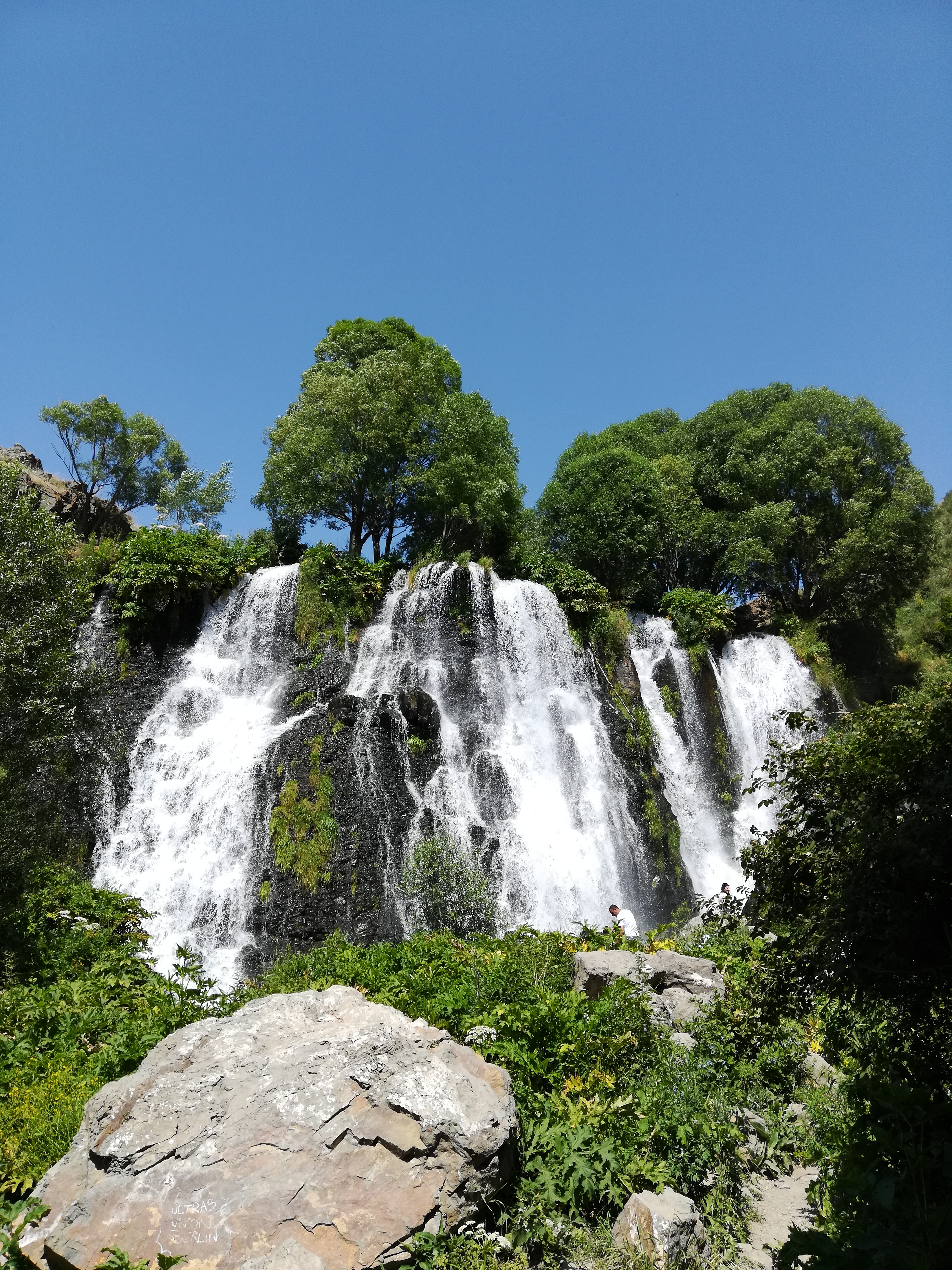
If you’ve ever dreamed of standing beneath a pristine waterfall that feels like a secret whispered by the mountains, Shaki Waterfall (Շաքիի ջրվեժ) is the spot you’ve been waiting for. Nestled near the tiny village of Angeghakot’ in Syunik’i Marz, this 18‑meter cascade drops into crystal‑clear pools framed by towering cliffs and verdant vegetation. Unlike the crowded tourist hotspots of Yerevan or Lake Sevan, Shaki Waterfall offers raw, untouched scenery that feels like stepping into a living postcard. Whether you’re planning a day‑trip, a weekend hiking adventure, or a photo‑shoot for your travel blog, this waterfall deserves a top spot on your Armenia itinerary.
2. About Շաքիի ջրվեժ
What makes Shaki Waterfall special?
- Height: 18 m (≈ 60 ft) – a dramatic plunge that creates a constant mist, perfect for rainbows on sunny days.
- Location: 39.552331 N, 45.993938 E, in the heart of Angeghakot’, Syunik’i Marz.
- Type: Natural waterfall, fed by seasonal mountain streams that swell after spring rains or early summer snowmelt.
A brief history & cultural significance
Shaki Waterfall is not only a natural wonder; it’s part of the local folklore that has been passed down through generations. The Armenian name “Շաքիի” (Shaki) is thought to be linked to the nearby Shaki River and the ancient practice of using the waterfall’s fresh water for irrigation and livestock. While there is no extensive written history, the waterfall has long served as a gathering place for villagers during festivals and as a tranquil spot for meditation.
The waterfall’s remote setting has helped preserve its pristine condition, making it a hidden gem for eco‑tourists seeking authentic Armenian landscapes. Its inclusion in the Armenian Wikipedia entry (see the reference: hy:Շաքիի ջրվեժ) underscores its growing recognition among nature enthusiasts.
3. How to Get There
From Yerevan (the capital)
| Step | Mode of Transport | Approx. Time | Notes |
|---|---|---|---|
| 1 | Drive (or hire a car) | 4–5 hours | Take the M-2 highway south toward Kapan, then follow signs for Angeghakot’. |
| 2 | Public Bus to Kapan | 4 hours | Buses depart from Yerevan’s Kilikia bus station. |
| 3 | Local Taxi / Shared Minibus from Kapan to Angeghakot’ | 30–45 min | Taxis are readily available; negotiate a flat rate. |
From the nearest city – Kapan
- Distance: ~15 km (≈ 9 mi)
- Road condition: Mostly paved, with a short gravel stretch approaching the village. A sturdy vehicle (or a careful driver) is recommended, especially after rain.
On‑foot approach
The waterfall sits only 0.2 km from a small dam and is easily reachable via a short, well‑marked trail that starts near the village’s central spring. The walk takes about 5‑10 minutes, making it accessible for families, seniors, and even casual walkers.
Pro tip: Bring a pair of sturdy walking shoes and a light rain jacket—the spray from the falls can be refreshing on a warm day.
4. Best Time to Visit
| Season | Conditions | Why Visit |
|---|---|---|
| Spring (April–June) | Snowmelt feeds the stream; water flow is strongest. Temperatures 12‑20 °C (54‑68 °F). | Lush green surroundings, vibrant wildflowers, and the most impressive cascade volume. |
| Summer (July–August) | Warm, dry days; occasional thunderstorms. Water flow moderates but remains steady. | Ideal for picnics and swimming in the natural pool; longer daylight for photography. |
| Autumn (September–October) | Cooler air, golden foliage. Water levels start to recede. | Stunning contrast of amber leaves against the turquoise water; fewer crowds. |
| Winter (November–March) | Possible ice formation; water flow reduced. Temperatures can drop below 0 °C (32 °F). | For the adventurous, a frosty landscape and the chance to see ice‑kissed rocks. |
Overall recommendation: Late spring to early autumn (May‑September) offers the best combination of water volume, pleasant weather, and accessibility.
5. What to Expect
The sensory experience
- Sight: The waterfall plunges 18 m into a sapphire pool, surrounded by limestone cliffs that echo the sound of rushing water. In bright sunlight, the mist creates miniature rainbows that dance across the rocks.
- Sound: A constant, soothing roar that drowns out distant traffic—perfect for meditation or a moment of quiet contemplation.
- Touch: The spray cools the air, offering a refreshing mist on hot days. The rocks near the pool are smooth from years of water flow, ideal for a brief rest.
- Smell: Fresh, earthy aromas of wet stone and surrounding pine/oak foliage fill the air.
Activities
- Photography: Capture long‑exposure shots of the cascading water or close‑ups of the moss‑covered rocks.
- Picnicking: Small wooden tables near the dam provide a perfect spot for a snack.
- Light Hiking: Extend your walk to the nearby dam (0.2 km) and waterfall (0.9 km) for a mini‑trek through the valley.
- Birdwatching: The area attracts several native species, including the Eurasian jay and golden eagle on higher perches.
6. Nearby Attractions
While Shaki Waterfall is the star of the show, the surrounding Syunik’i Marz offers several complementary sites that can easily be added to your itinerary:
| Attraction | Distance from Shaki Waterfall | Type | Quick Link |
|---|---|---|---|
| Dam #1 | 0.2 km | Small hydro‑dam (functional) | View on map |
| Dam #2 | 0.8 km | Secondary dam, scenic viewpoint | View on map |
| Nearby Waterfall | 0.9 km | Another modest cascade, perfect for a short side‑trip | View on map |
| Weir #1 | 3.6 km | Historic weir used for traditional irrigation | View on map |
| Weir #2 | 3.7 km | Similar to Weir #1, offers a glimpse into local water‑management heritage | View on map |
These spots are all reachable on foot or by a short drive, allowing you to create a full day of nature exploration without long detours.
7. Travel Tips
| Tip | Details |
|---|---|
| Plan your route ahead | Mobile signal can be spotty in the mountains; download offline maps (Google Maps or MAPS.ME) using the coordinates 39.552331, 45.993938. |
| Dress in layers | Weather can shift quickly, especially in spring and autumn. A light jacket and breathable shirt work best. |
| Stay hydrated & bring snacks | While there are small kiosks in Angeghakot’, they may close early. Pack water and a light snack. |
| Respect the environment | Keep the area clean—take any trash back with you. Stick to marked trails to protect fragile vegetation. |
| Photography gear | A tripod and neutral density filter help capture silky water effects. A waterproof case protects gear from spray. |
| Safety first | The rocks near the pool can be slippery when wet. Use non‑slip shoes and watch children closely. |
| Local etiquette | Armenians are warm and hospitable. A friendly “Բարև” (barev – hello) goes a long way. If you stop to chat with locals, a small purchase (e.g., a homemade jam) is appreciated. |
| Currency | The Armenian dram (AMD) is the official currency. Small cash amounts are useful for village shops. |
| Timing | Arrive early (7–8 am) to avoid any small crowds and enjoy the soft morning light for photos. |
Final Thought
Shaki Waterfall may not appear on every mainstream travel brochure, but that’s precisely why it feels like a personal discovery. Its 18‑meter plunge, tranquil surroundings, and proximity to other modest yet charming sites make it an ideal destination for anyone seeking authentic Armenian nature. Pack your camera, lace up your boots, and let the mist of Shaki Waterfall refresh both body and soul.
Happy travels, and may your journey through Syunik be as refreshing as the cascade itself!