Tilaiya Dam, Jharkhand – A Hidden Gem for Nature Lovers
Coordinates: 24.324275 N, 85.521012 E | Location: Patamda, Jharkhand, India
Introduction
If you’re chasing off‑beat destinations that blend engineering marvels with serene natural scenery, Tilaiya Dam should be at the top of your list. Nestled in the rolling hills of Patamda, this modest yet picturesque dam offers a tranquil escape from the hustle of India’s big cities. Whether you’re a photography enthusiast, a weekend road‑tripper, or a student of Indian water‑resource projects, Tilaiya Dam delivers a slice of calm and a dash of adventure—all set against the lush backdrop of Jharkhand’s forested landscape.
About Tilaiya Dam
A Quick Snapshot
- Type: Dam 🏗️
- Location: Patamda, Jharkhand, India
- Coordinates: 24.324275 N, 85.521012 E
- Height / Altitude: Data not publicly disclosed
- Wikipedia: Tilaiya Dam
History & Significance
Tilaiya Dam was constructed as part of the early post‑independence efforts to harness the water resources of the Barakar River basin (the river that feeds the dam). While the exact year of completion is not highlighted in the public record, the dam has long served as a critical source of irrigation for the surrounding agricultural lands and contributes to the regional water‑supply network.
Beyond its utilitarian role, the reservoir created by the dam has become a modest recreational spot for locals and travelers alike. The calm waters reflect the surrounding hills, making it a perfect spot for sunrise and sunset photography. Its relatively low‑key profile means you can enjoy the scenery without the crowds that flock to larger, more commercialized dams in India.
How to Get There
By Air
The nearest major airport is Birsa Munda Airport in Ranchi, Jharkhand’s capital. From Ranchi, you can rent a car or book a taxi for the onward journey to Patamda. The drive typically takes around 2–3 hours, depending on traffic and road conditions.
By Train
Jharkhand’s rail network connects several key towns to the region. The closest railway stations with regular service are Koderma Junction and Hazaribagh Town. From either station, you can catch a shared taxi, auto‑rickshaw, or local bus that heads toward Patamda.
By Road
Tilaiya Dam is well‑connected by state highways that link Patamda with Ranchi, Hazaribagh, and Dhanbad. If you prefer a self‑drive adventure, renting a car or hiring a driver in Ranchi is straightforward. The route is scenic, winding through tea‑plantation‑like valleys and dense forest patches—ideal for a relaxed road‑trip vibe.
Pro tip: The most reliable way to locate the exact turn‑off for the dam is to use the coordinates (24.324275 N, 85.521012 E) in any GPS navigation app. The dam’s signage near Patamda is clear, but a digital map eliminates any guesswork.
Best Time to Visit
| Season | Weather | Visitor Experience |
|---|---|---|
| Winter (Nov – Feb) | Cool, dry, occasional fog | Crisp mornings perfect for sunrise shots; water levels are stable. |
| Spring (Mar – Apr) | Pleasant, mild temperatures | Wildflowers bloom around the reservoir, adding color to your photos. |
| Monsoon (May – Sep) | Heavy rain, higher water flow | The dam’s spillways are active, creating dramatic water displays—but roads may be slippery. |
Recommendation: For most travelers, late October to early March offers the most comfortable climate and clear visibility. If you love the raw power of water, a monsoon visit can be thrilling, just ensure you have waterproof gear and check local road conditions.
What to Expect
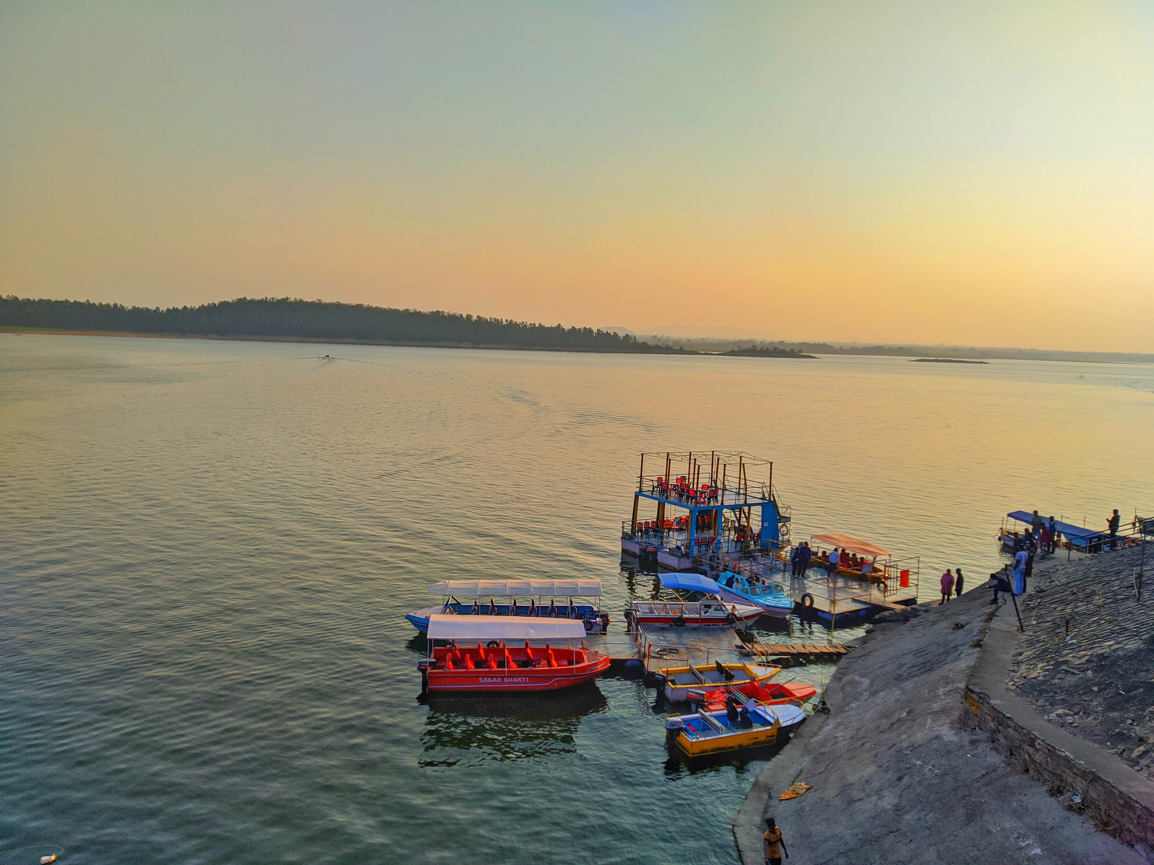
Scenic Views
Approaching Tilaiya Dam, you’ll first notice the gentle rise of the water against a backdrop of low‑lying hills. The reservoir stretches over a modest area, its surface often mirroring the sky—ideal for reflective photography. The dam wall itself is a concrete structure that blends into the surrounding greenery, giving a sense of harmony between man‑made and natural elements.
Activities
- Photography & Birdwatching: Early mornings bring a chorus of local birds, and the calm water provides mirror‑like reflections.
- Picnics: Small shaded spots near the embankment are perfect for a relaxed lunch. Pack a light meal and enjoy the fresh, earthy air.
- Leisure Walks: A short, informal trail circles part of the reservoir, allowing you to explore the flora and catch glimpses of local wildlife (mostly small mammals and reptiles).
Facilities
The site is modestly developed. Expect basic amenities such as clean drinking water taps and a few restroom blocks maintained by the local authorities. There are no large commercial eateries, so it’s wise to bring snacks or a packed meal.
Nearby Attractions
While Tilaiya Dam is the star of the itinerary, the surrounding region offers several other water‑related points of interest that can be combined into a day‑trip loop:
| Attraction | Approx. Distance | What to See |
|---|---|---|
| Unnamed Dam (12.9 km) | 12.9 km | Small reservoir with a quiet picnic area. |
| Unnamed Weir (21.5 km) | 21.5 km | A classic weir structure, great for engineering enthusiasts. |
| Unnamed Dam (23.5 km) | 23.5 km | Scenic water body surrounded by dense forest. |
| Unnamed Dam (28.5 km) | 28.5 km | Popular spot for local anglers. |
| Unnamed Dam (30.2 km) | 30.2 km | Offers a short trekking trail along its banks. |
While specific names are not listed in public sources, you can locate these sites using the distance markers on Google Maps or by asking locals in Patamda. They all fall under the broader category of “Dams in Jharkhand,” which you can explore here: Dams in Jharkhand (Wikipedia).
Travel Tips
- Carry Cash: Small vendors and local transport operators may not accept digital payments.
- Dress Comfortably: Light layers work best—mornings can be chilly in winter, while afternoons warm up quickly.
- Stay Hydrated: Even though the climate is moderate, the altitude and forest humidity can dehydrate you faster than expected.
- Respect the Environment: The area is ecologically sensitive. Avoid littering, and stick to designated pathways.
- Check Road Conditions: During monsoon months, some rural roads can become slippery or temporarily closed. A quick call to a local guesthouse or the Patamda Panchayat office can save you a detour.
- Timing for Photos: The golden hour—just after sunrise and just before sunset—offers the most dramatic lighting over the water.
- Local Cuisine: If you’re hungry, try the litti chokha or pitha sold by roadside stalls in Patamda; they’re hearty and flavorful.
Wrap‑Up
Tilaiya Dam may not headline the typical “must‑see” list for Jharkhand, but that’s precisely why it feels like a secret retreat. Its calm waters, easy accessibility, and proximity to other lesser‑known water sites make it an ideal base for a low‑key, nature‑focused getaway. Pack your camera, hop in a car, and let the gentle ripple of Tilaiya’s reservoir guide you into the heart of Jharkhand’s quiet charm.
Happy travels!