Discover the Hidden Gem of San Juan: Dique Gobernador Carlos Enrique Gómez Centurión
Your ultimate travel guide to one of Argentina’s most tranquil dam destinations.
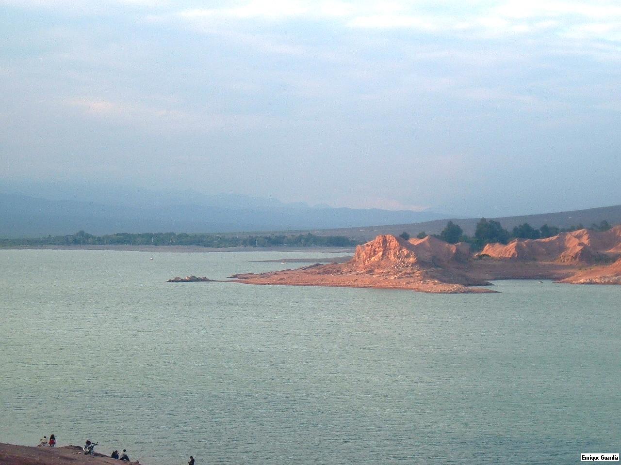
1. Introduction
Imagine a place where the gentle ripple of water meets the stark beauty of the Argentine Andes, where the scent of eucalyptus mingles with the crisp mountain air, and where you can step off the beaten path into a landscape that feels both timeless and untouched. Welcome to Dique Gobernador Carlos Enrique Gómez Centurión – a modest yet captivating dam tucked away in the Rivadavia district of San Juan, Argentina. Whether you’re a seasoned road‑tripper, a nature photographer, or a traveler hunting off‑the‑radar spots, this dam offers a perfect blend of serenity, scenic vistas, and authentic Argentine charm.
2. About Dique Gobernador Carlos Enrique Gómez Centurión
A Brief Overview
- Type: Dam (🏗️)
- Location: Rivadavia, San Juan, Argentina
- Coordinates: -31.474813, -68.650414
- Height: 13 m
- Altitude: Not publicly disclosed
The dam is officially known as Dique Gobernador Carlos Enrique Gómez Centurión, named after the former governor of San Juan who championed water‑resource projects in the mid‑20th century. While the structure itself is relatively modest—standing just 13 meters tall—it plays an essential role in the region’s irrigation network, supporting the vineyards and orchards that dot the province’s fertile valleys.
Historical Significance
Built during a wave of infrastructural development aimed at harnessing the arid Cuyo region’s scarce water, the dam helped transform San Juan from a desert‑like landscape into a thriving agricultural hub. Its construction marked a turning point for local communities, providing a reliable water supply for both farming and domestic use. Over the decades, the reservoir has also become a beloved gathering spot for families, anglers, and hikers who appreciate its peaceful ambience.
Why It Matters for Travelers
Beyond its functional importance, the dam offers a glimpse into Argentina’s lesser‑known engineering heritage. The surrounding area is a canvas of ochre‑colored hills, native shrubland, and distant snow‑capped peaks—perfect for sunrise photography or a quiet afternoon picnic. Because it’s not a mainstream tourist magnet, you’ll often find the site uncrowded, allowing you to soak in the natural beauty at your own pace.
3. How to Get There
By Air
The nearest major airport is San Juan International Airport (SLA), located about 70 km north of the dam. From the airport, you can rent a car or arrange a private transfer. The drive takes roughly 1 hour 15 minutes, depending on traffic.
By Car
- From San Juan City: Take National Route 40 (Ruta Nacional 40) heading south toward the town of Rivadavia. After passing the town’s central plaza, follow the signs for the dam—look for a small turnoff onto a paved service road that leads directly to the reservoir.
- From Mendoza: Head east on National Route 7, then turn south onto National Route 40 at San Carlos. Continue for about 130 km to Rivadavia, then follow the same local directions.
The roads are generally well‑maintained, but be prepared for occasional gravel sections as you approach the dam. A GPS device or a smartphone map using the coordinates -31.474813, -68.650414 will guide you straight to the parking area.
Public Transport
Regular bus services run between San Juan City and Rivadavia. Once in Rivadavia, you can catch a local taxi or a “colectivo” (shared minivan) that will drop you off near the dam. The journey is inexpensive, though schedules may be limited on weekends.
4. Best Time to Visit
| Season | Weather | Why Visit |
|---|---|---|
| Spring (Sept‑Nov) | Mild temperatures (15‑25 °C), blooming wildflowers | Ideal for photography and picnics |
| Summer (Dec‑Feb) | Warm to hot (25‑35 °C), occasional thunderstorms | Great for swimming in the reservoir (if permitted) |
| Autumn (Mar‑May) | Cool evenings, golden foliage | Perfect for sunset views and birdwatching |
| Winter (Jun‑Aug) | Cold (5‑15 °C), occasional frost | Quietest period, dramatic mountain backdrops |
Top Recommendation: Late spring (late October to early November) offers comfortable weather, vibrant flora, and clear skies—optimal for outdoor activities and capturing the dam’s reflections on camera.
5. What to Expect
Scenic Landscape
Arriving at the dam, you’ll be greeted by a tranquil water surface that mirrors the surrounding hills. The reservoir’s modest size makes it feel intimate, while the distant Andes provide a dramatic backdrop. Early mornings often feature a soft mist that lifts as the sun climbs, creating ethereal photo opportunities.
Activities
- Walking & Hiking: A short, well‑marked trail circles the reservoir, offering several lookout points. The path is suitable for all fitness levels.
- Photography: The interplay of light on water, the rustic dam walls, and the rugged terrain make for compelling shots.
- Picnicking: There are shaded spots with picnic tables near the parking area—bring a local cheese and a bottle of Malbec for a true Argentine experience.
- Birdwatching: Keep an eye out for native species such as the Andean condor, Baird’s sandpiper, and various raptors that patrol the open skies.
Facilities
- Parking: A small lot accommodates cars and motorcycles.
- Restrooms: Basic facilities are available near the entrance.
- Information Board: A modest plaque provides historical context and safety guidelines.
Because the site is not heavily commercialized, there are no cafés or souvenir shops on‑site. It’s advisable to bring water, snacks, and sun protection.
6. Nearby Attractions
While the dam itself is a rewarding stop, the surrounding region offers several other points of interest that can be combined into a day‑trip itinerary:
| Attraction | Distance | Highlights | Link |
|---|---|---|---|
| Vertedero (dam) | 0.2 km | Small spillway, perfect for close‑up engineering shots | Vertedero (dam) |
| Control Compuertas (dam) | 0.3 km | Operational gate control area, interesting for water‑management enthusiasts | Control Compuertas (dam) |
| Local Fountain | 2.2 km | Charming community fountain, ideal for a quick photo break | Fountain |
| Dique Partidor José Ignacio De La Roza | 3.1 km | Larger reservoir used for hydro‑electric generation, offers scenic boat rides (check local regulations) | Dique Partidor José Ignacio De La Roza (1) |
| Dique Partidor José Ignacio De La Roza | 3.2 km | Same as above—extra access point for hikers | Dique Partidor José Ignacio De La Roza (2) |
Tip: All the above sites are within a short drive, making it easy to explore multiple dams and natural spots in a single outing.
7. Travel Tips
- Carry Cash: Small rural towns often accept only cash for fuel, food, or souvenirs.
- Stay Sun‑Safe: The high altitude means UV radiation is stronger. Wear a hat, sunglasses, and sunscreen.
- Check Water Levels: Seasonal fluctuations can affect the reservoir’s appearance and accessibility. A quick call to the local municipal office in Rivadavia can confirm conditions.
- Respect the Environment: Pack out all trash, stay on marked trails, and avoid feeding wildlife.
- Fuel Up Early: Gas stations are sparse between San Juan City and Rivadavia; fill up before you leave the city.
- Mobile Coverage: Signal can be spotty near the dam. Download offline maps (Google Maps, Maps.me) using the coordinates -31.474813, -68.650414.
- Local Cuisine: After your dam visit, head to Rivadavia’s town center for a traditional asado or empanadas paired with a glass of Torrontés wine from nearby vineyards.
Wrap‑Up
Dique Gobernador Carlos Enrique Gómez Centurión may not headline the usual travel itineraries, but that’s precisely why it shines for the curious explorer. Its blend of engineering history, pristine natural scenery, and proximity to other hidden gems makes it a perfect addition to any San Juan adventure. Pack your camera, hit the road, and let this quiet Argentine dam reveal its calm, captivating spirit.
Happy travels!