Dique Cruz del Eje “Arturo Illía”: A Hidden Gem in Córdoba, Argentina
Your ultimate guide to visiting the stunning Cruz del Eje dam, practical travel tips, and nearby attractions you won’t want to miss.
1. Introduction
Imagine a crystal‑clear reservoir framed by rolling hills, the gentle hum of water spilling over a 40‑metre‑high concrete wall, and the scent of eucalyptus drifting on the breeze. That’s Dique Cruz del Eje “Arturo Illía”, a modest yet captivating dam tucked away in the heart of Córdoba province, Argentina. Whether you’re a road‑trip enthusiast, a photography lover, or simply seeking a peaceful spot to unwind, this dam offers a refreshing escape from the bustle of the city. In this guide we’ll dive into the dam’s story, how to reach it, the best time to visit, what you’ll experience on‑site, and the surrounding points of interest that make the area a mini‑adventure hub.
2. About Dique Cruz del Eje “Arturo Illía”
- Location: Cruz del Eje, Córdoba, Argentina
- Coordinates: -30.761938, -64.752484
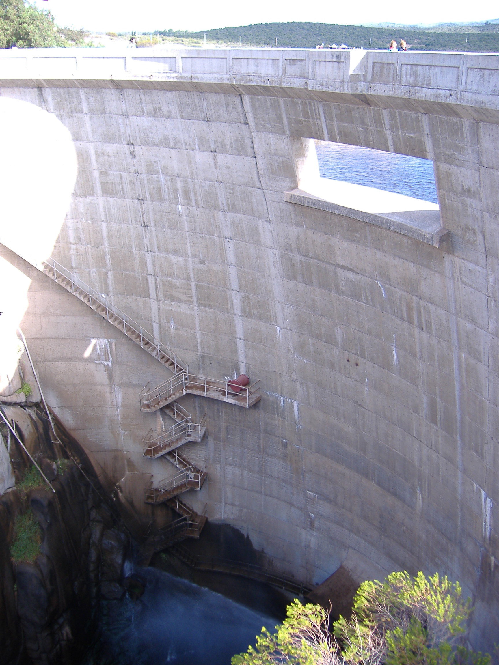
- Type: Concrete dam (🏗️)
- Height: 40 m
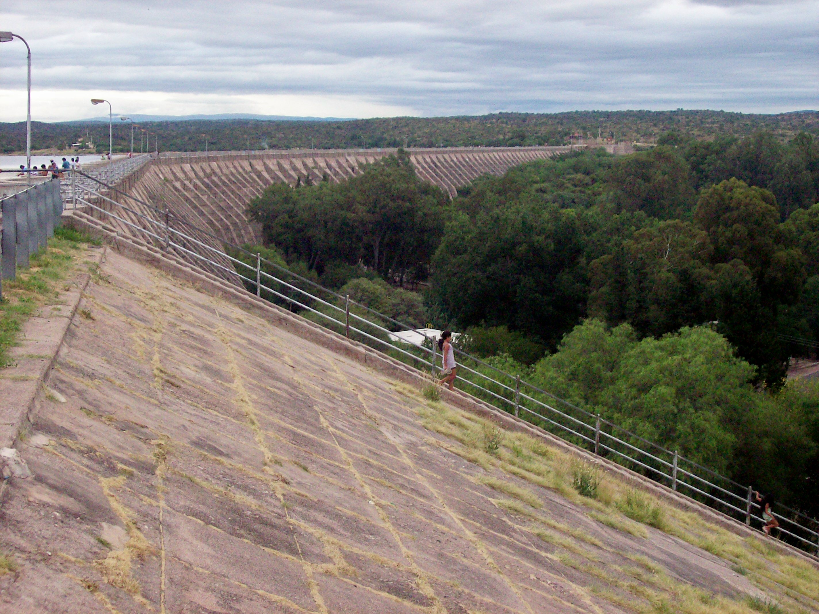
The reservoir—locally known as Embalse de Cruz del Eje—was built to regulate the flow of the Cruz del Eje River, providing water for irrigation, hydro‑electric generation, and flood control. The dam carries the name “Arturo Illía” in tribute to the former Argentine president who championed regional development projects during the 1960s. While the structure itself may not rival the massive dams of Patagonia, its modest scale creates an intimate setting that feels more like a natural lake than an industrial installation.
Beyond its utilitarian purpose, the dam has become a community focal point. Locals gather for weekend picnics, anglers cast lines for trucha (rainbow trout), and cyclists enjoy the paved perimeter trail that circles the water’s edge. The reservoir’s calm surface reflects the surrounding Sierras de Córdoba, offering picture‑perfect moments at sunrise and sunset.
3. How to Get There
By Air
The closest major airport is Ingeniero Aeronáutico Ambrosio L.V. Taravella International Airport (COR) in Córdoba City, about 140 km (≈ 2 h 30 min drive) from the dam. From the airport, rent a car or arrange a shuttle to the town of Cruz del Eje.
By Car
Driving is the most flexible way to reach the dam:
| Starting Point | Route | Approx. Time | Notes |
|---|---|---|---|
| Córdoba City | Take Ruta Nacional 20 west toward Cruz del Eje → follow signs for Ruta Provincial 20 → turn left onto Ruta Provincial 36 leading directly to the dam. | 2 h 30 min | Well‑paved highway; tolls may apply on RN‑20. |
| Villa Carlos Paz | Head north on Ruta Nacional 20 → same as above. | 1 h 45 min | Scenic drive through the Sierras. |
| San Francisco (Catamarca) | Cross into Córdoba via Ruta Nacional 20 → follow the same directions. | 3 h 15 min | Good for a day‑trip from the north. |
Parking is free at the Dique Cruz del Eje visitor area, with space for cars, motorcycles, and small buses.
By Public Transport
Buses operated by Empresa del Norte run regular services from Córdoba City to Cruz del Eje (approximately every 2 hours). Once in town, a short taxi or local colectivo ride (≈ 10 min) will drop you off at the dam’s entrance. Check the latest schedule on the company’s website or at the Córdoba bus terminal.
By Bike
For the adventurous, the Ruta Provincial 36 bike lane offers a rewarding ride (≈ 70 km) from the town of Cruz del Eje to the reservoir. Bring plenty of water and a repair kit—services are limited along the route.
4. Best Time to Visit
Córdoba enjoys a temperate continental climate: hot, dry summers (December – February) and mild, wetter winters (June – August).
| Season | Weather | Why Visit? |
|---|---|---|
| Spring (Sept‑Nov) | Pleasant 18‑25 °C, blooming wildflowers | Ideal for photography, birdwatching, and picnics. |
| Autumn (Mar‑May) | Cool 12‑20 °C, golden foliage | Perfect for sunrise/sunset shots and comfortable hikes. |
| Summer (Dec‑Feb) | Warm 28‑35 °C, occasional thunderstorms | Good for swimming and water‑sports, but bring sun protection. |
| Winter (Jun‑Aug) | Mild 8‑15 °C, occasional frost | Quiet atmosphere; great for a peaceful walk, but some facilities may close early. |
Peak visitation occurs in spring and early autumn when the weather is mild and the reservoir’s water level is typically high, providing the best reflections for photographers. If you prefer solitude, aim for a weekday in late autumn or early winter.
5. What to Expect
Scenic Views
From the main viewpoint, the dam’s 40 m wall dominates the horizon, while the reservoir stretches out like a mirror. Early morning mist often lifts off the water, creating ethereal scenes that attract Instagrammers and landscape artists alike.
Outdoor Activities
| Activity | Details |
|---|---|
| Walking / Trail Running | A 4 km paved loop circles the reservoir, with benches and interpretive panels describing the dam’s engineering. |
| Fishing | Permit‑free fishing for trout and pejerrey (silverside) is allowed from the shore. Bring a simple rod and bait; local shops in Cruz del Eje sell everything you need. |
| Kayaking / Paddle‑boarding | Small rental kiosks operate during the high‑water season (Nov‑Mar). The calm water is perfect for beginners. |
| Birdwatching | Look for Southern Caracara, Burrowing Owl, and a variety of waterfowl. Bring binoculars for the best experience. |
| Picnicking | Designated grassy areas with BBQ grills are available on a first‑come, first‑served basis. |
Amenities
- Restrooms: Clean facilities near the visitor center (open 8 am‑6 pm).
- Visitor Center: Small museum with photographs of the dam’s construction and interactive maps.
- Café “La Ribera”: Serves empanadas, fresh juices, and Argentine coffee.
Atmosphere
The dam is less crowded than the famous Los Molinos or Los Pico reservoirs, offering a relaxed vibe. Locals often greet visitors with a warm “¡Che, bienvenido!” and are happy to share fishing tips or recommend a nearby parrilla (steakhouse).
6. Nearby Attractions
While Dique Cruz del Eje is the star, the surrounding area boasts several points of interest within a short drive. All distances are measured from the dam’s main parking lot.
| Attraction | Type | Distance | Why Visit? | Link |
|---|---|---|---|---|
| Compuertas | Weir | 0.9 km | A historic weir that regulates water flow into the reservoir. Great for a quick photo stop. | Google Maps |
| Fountain #1 | Fountain | 4.2 km | A charming stone fountain nestled in a small plaza of the town center. Ideal for a coffee break. | Google Maps |
| Fountain #2 | Fountain | 6.2 km | Surrounded by native jacaranda trees; the water’s gentle sound creates a tranquil setting. | Google Maps |
| Fountain #3 | Fountain | 7.0 km | Features a decorative sculpture of a local legend—perfect for culture lovers. | Google Maps |
| Weir “La Cañada” | Weir | 12.4 km | An engineering landmark that offers insight into the region’s water management history. | Google Maps |
Tip: Combine a visit to the dam with a short drive to these attractions for a full‑day itinerary. The fountains are especially lovely in the late afternoon when the sun casts a warm glow.
7. Travel Tips
- Check Water Levels – The reservoir’s surface can fluctuate dramatically during the dry season. Visit the local municipality’s website or call the visitor center (☎ +54 351 xxx xxxx) for current conditions.
- Bring Sun Protection – Even on cloudy days, the high altitude (≈ 800 m above sea level) intensifies UV rays. Pack sunscreen, a hat, and sunglasses.
- Stay Hydrated – There are limited refill stations; carry at least 2 L of water per person, especially if you plan to hike or fish.
- Cash is King – Small kiosks and the café accept only cash (ARS). ATMs are available in Cruz del Eje town, about 5 km away.
- Respect the Environment – The area is a protected watershed. Pack out all trash, stay on marked trails, and avoid feeding wildlife.
- Parking – Arrive early on weekends to secure a spot near the main viewpoint; the lot fills up quickly after 10 am.
- Local Cuisine – Try the empanada de cabrito at a nearby parrilla; it’s a regional specialty you won’t find in the city.
- Connectivity – Mobile signal can be spotty near the dam. Download offline maps (Google Maps or Maps.me) before you go.
Ready to Explore?
Dique Cruz del Eje “Arturo Illía” may not appear on every travel brochure, but its blend of engineering history, natural beauty, and laid‑back Argentine charm makes it a must‑see for