Presa San Martín – The Hidden Hydro‑Power Gem of Argentine Patagonia
Discover the towering 120‑metre dam perched above Trevelin, Chubut, and explore the wild beauty that surrounds it.
Introduction
If you think Patagonia is only about glaciers, towering peaks, and endless steppes, think again. Tucked away in the verdant valleys of western Chubut, Presa San Martín rises 120 m above the Futaleufú River, forming a dramatic backdrop for one of Argentina’s most impressive hydro‑electric projects. The dam’s sleek concrete silhouette, framed by lenga forests and snow‑capped Andes, makes it a photographer’s dream and an off‑the‑beaten‑path stop for adventurous travelers. Whether you’re a road‑trip enthusiast cruising the legendary Ruta 40, a bird‑watcher chasing Andean condors, or a curious traveler eager to learn how Patagonia powers its towns, Presa San Martín offers a unique blend of engineering marvel and natural splendor.
About Presa San Martín
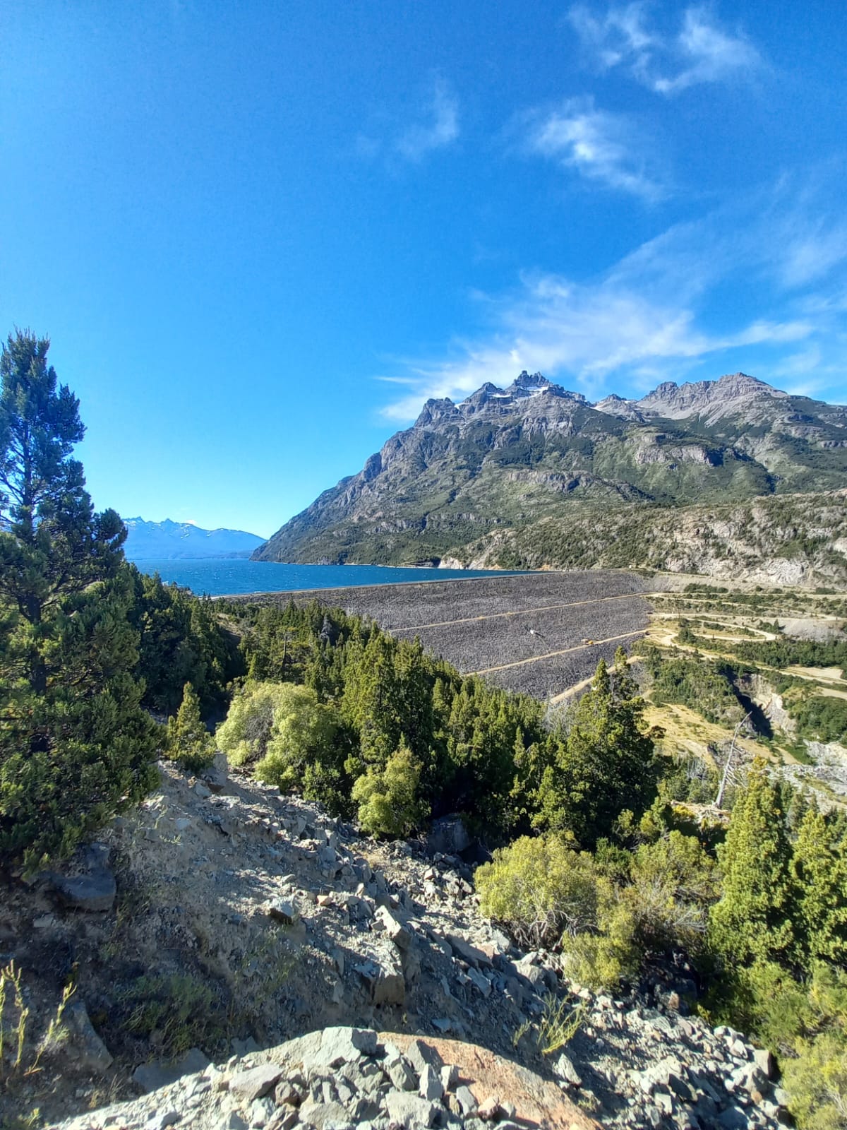
Presa San Martín is a concrete gravity dam that forms part of the Futaleufú hydroelectric complex (Spanish: Complejo hidroeléctrico Futaleufú). Built to harness the kinetic energy of the Futaleufú River, the dam stands 120 m tall and lies at the coordinates ‑43.109376, ‑71.651339, just outside the small town of Trevelin.
History & Significance
The Futaleufú complex was conceived in the late 20th century as a strategic effort to provide clean, renewable electricity to the growing settlements of Argentine Patagonia, while also supporting the mining and tourism sectors. Presa San Martín, together with the nearby Presa Futaleufú (only 0.1 km away), forms the core of this system, feeding water through underground penstocks to turbines that generate megawatts of power for the region.
While the exact year of completion is not publicly detailed, the dam’s presence has transformed the local economy: it supplies reliable electricity to Trevelin, Esquel, and surrounding rural communities, and it has become a subtle yet powerful symbol of Patagonia’s commitment to sustainable development.
Why It Matters
- Renewable Energy – The dam contributes to Argentina’s national goal of increasing renewable electricity generation.
- Tourism Magnet – Its striking height and the crystal‑clear reservoir attract hikers, cyclists, and photographers.
- Ecological Balance – By regulating river flow, the dam helps protect downstream ecosystems, especially during the dry summer months.
How to Get There
By Air
The closest commercial airport is Almirante Armando S. Rogers (ESQ) – Esquel Airport, about 70 km north‑west of Trevelin. From the airport, rent a car or catch a shuttle to the town of Trevelin (≈ 1 hour on Ruta 40).
By Bus
Long‑distance bus companies such as CATA Internacional and Andesmar run regular services from Bariloche, Buenos Aires, and Comodoro Rivadavia to Trevelin. The bus ride from Bariloche takes roughly 7 hours, offering scenic views of the Andes along the way.
By Car
Driving is the most flexible option. From Esquel, follow Ruta 40 south‑west for 70 km; the road is paved and well‑marked. Turn onto the Presa San Martín access road (signposted “Complejo Hidroeléctrico Futaleufú”). The dam’s parking lot sits just a few minutes from the main viewpoint.
- GPS coordinates:
-43.109376, -71.651339 - Fuel stations: Available in Trevelin and Esquel.
Public Transport & Tours
Local tour operators in Trevelin offer half‑day “Hydro‑Power & Nature” packages that include a guided walk to the dam, safety briefings, and a stop at the nearby waterfalls. Check out Patagonia EcoTours or Trevelin Adventure for schedules.
Best Time to Visit
| Season | Weather | Visitor Experience |
|---|---|---|
| Spring (Oct‑Nov) | Mild temperatures (10‑18 °C), blooming lenga forests | Ideal for photography; river flow is moderate, making the reservoir sparkle. |
| Summer (Dec‑Feb) | Warm days (15‑25 °C), occasional thunderstorms | Peak tourist season; longer daylight for hikes, but river levels can be high. |
| Autumn (Mar‑May) | Cool, crisp air (8‑16 °C), golden foliage | Best for tranquil walks and bird‑watching; water levels start to recede, revealing more shoreline. |
| Winter (Jun‑Sep) | Cold (0‑8 °C), occasional snow on surrounding peaks | Fewer visitors; the dam’s silhouette against a snow‑capped backdrop is spectacular, but some access roads may be icy. |
Overall recommendation: Late spring (mid‑October to early November) or early autumn (late March to early April) provide comfortable weather, vibrant colors, and manageable crowds.
What to Expect
The Viewpoint
A short, well‑maintained trail leads from the parking area to a panoramic viewpoint perched on a rocky outcrop. From here you can see the full height of Presa San Martín, the turquoise reservoir, and the cascading Futaleufú River downstream. The sight of water spilling over the dam’s spillways during a controlled release is both awe‑inspiring and a reminder of the power harnessed here.
The Reservoir
The reservoir stretches roughly 2 km upstream, its surface reflecting the surrounding Andes. Kayakers and paddle‑boarders occasionally glide across the calm water, though most visitors stay on shore to enjoy the peaceful ambience.
Wildlife
Patagonian fauna is abundant:
- Andean condors soaring on thermal currents.
- Huillín (southern river otter) occasionally spotted near the water’s edge.
- Patagonian foxes and guanacos roaming the nearby grasslands.
Bird‑watchers will love the diversity of raptors and waterbirds that frequent the area, especially during migration periods.
Facilities
- Parking: Free, with a capacity for 30 vehicles.
- Restrooms: Basic facilities near the viewpoint.
- Information kiosk: Small board with details about the dam’s construction, hydro‑electric capacity, and safety guidelines.
- Picnic area: Benches and a shaded table under native trees.
Nearby Attractions
While Presa San Martín is the star, the surrounding valley offers several natural gems that are perfect for a day‑trip itinerary:
| Attraction | Distance | What to See | Link |
|---|---|---|---|
| Presa Futaleufú (dam) | 0.1 km | Twin dam of the same hydro‑electric complex; great for comparative photos. | Presa Futaleufú |
| Unnamed Dam | 2.5 km | Smaller auxiliary dam; quieter spot for contemplation. | — |
| Sendero Cascada de los Tambores (trail) | 3.1 km | Hiking trail leading to a series of waterfalls; moderate difficulty. | — |
| Cascada de los Tambores (waterfall) | 3.1 km | The main waterfall on the trail; perfect for a refreshing splash. | — |
| Portada Hidroeléctrica Futaleufú (waterfall) | 4.1 km | Dramatic waterfall that feeds directly into the hydro‑electric system; excellent for sunset shots. | — |
Tip: Combine the dam visit with a guided hike to Cascada de los Tambores. The trail is well‑marked, and the waterfall’s roar provides a natural soundtrack to your adventure.
Travel Tips
- Bring Layers – Patagonian weather changes quickly; a waterproof jacket and warm layers are essential even in summer.
- Stay Hydrated – The altitude (exact figure not published) can cause mild altitude effects; drink plenty of water.
- Respect the Environment – The area is a protected watershed; pack out all trash and stay on marked paths.
- Timing for Spillway Views – Check the local information board for scheduled water releases; these create spectacular spray arcs.
- Photography Gear – A wide‑angle lens captures the dam’s height; a telephoto lens is useful for wildlife. Sunrise and sunset provide the best lighting.
- Safety First – The reservoir’s edges can be slippery; keep children supervised and heed any warning signs near the spillways.
- Currency – Argentine pesos are accepted locally; many small vendors also take credit cards, but carry cash for remote purchases.
- Language – Spanish is the primary language; a few basic phrases (e.g., “¿Dónde está la vista del dam?”) go a long way.
Final Thoughts
Presa San Martín may not yet be on every traveler’s bucket list, but its blend of engineering prowess, Patagonian scenery, and peaceful solitude makes it a hidden treasure worth seeking out. Pair the dam with nearby waterfalls, savor the crisp mountain air, and you’ll leave Trevelin with unforgettable memories of Argentina’s southern frontier.
Pack your camera, fuel up the SUV, and let the Andes guide you to this remarkable dam—where water, stone, and sky converge in perfect harmony.


