Kundalila Falls – Zambia’s Hidden Waterfall Gem
Discover the roar, the mist, and the unforgettable adventure that awaits at Kundalila Falls, the 80‑metre cascade perched in the heart of Central Province, Zambia.
Introduction
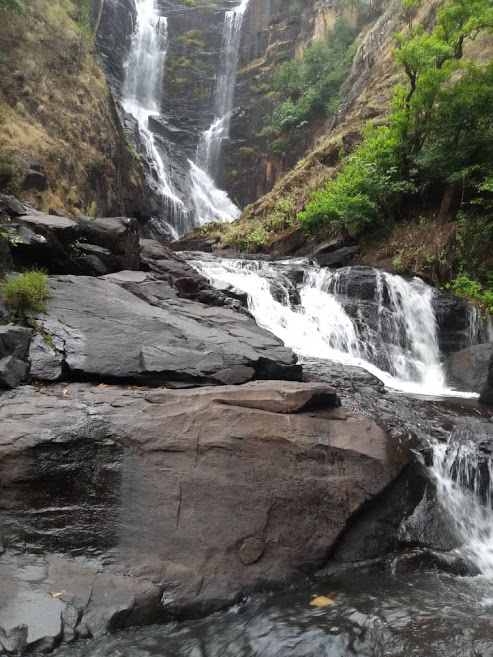
If you’re chasing the road less travelled in Africa, the moment you set eyes on Kundalila Falls you’ll know why this secluded waterfall is a must‑see. Tucked away near the town of Serenje in Central Province, the falls tumble 80 metres down a rugged cliff, sending a veil of cool mist into the surrounding forest. The sound of rushing water, the lush greenery, and the sense of being far from the tourist crowds make Kundalima Falls a perfect spot for photographers, hikers, and anyone craving a genuine Zambian wilderness experience.
Quick fact: Kundalila Falls sits at latitude ‑13.154041 and longitude 30.703991 – a handy coordinate you can paste straight into your GPS for pinpoint navigation.
About Kundalila Falls
Kundalila Falls (sometimes spelled Kundalima) is a natural waterfall on the Kundalila River, a tributary of the larger Luangwa basin. The name “Kundalila” is derived from the local Bemba language, meaning “the place where the river roars.”
History & Significance
While the falls have long been a sacred site for the local Bemba people, they only entered the wider travel consciousness in the early 2000s when adventure‑tour operators began promoting Zambia’s interior beyond the famed Victoria Falls. The waterfall is not only a scenic highlight but also an important ecological zone. Its mist‑laden micro‑climate supports a variety of ferns, orchids, and endemic bird species, making it a small biodiversity hotspot.
Because the falls are situated in a relatively remote area, they have retained much of their natural character. There are no large commercial developments on the banks, allowing visitors to experience the raw power of the water and the tranquil ambience of the surrounding forest.
How to Get There
By Air
The nearest major airport is Kenneth Kaunda International Airport (LUN) in Lusaka, roughly 250 km south‑west of Kundalila Falls. From Lusaka, you can charter a small plane to Serenje Airport (SRW), which lies about 15 km from the falls. Private charters are the fastest but also the most expensive option.
By Road
Most travelers opt for a scenic road trip:
-
From Lusaka:
* Take the T2 (Great North Road) north toward Kabwe.
* Continue on the T2 past Kapiri Mposhi and head east on the M1 toward Serenje.
* The total drive is approximately 300 km and takes 5–6 hours, depending on road conditions. -
From Chipata:
* Follow the M14 westward, then join the M1 south toward Serenje. -
From Serenje Town:
* The falls are about 25 km north of the town centre. A local minibus (known as a “komboni”) or a hired 4×4 can take you the short final stretch.
On the Ground
The last leg of the journey involves a rough, unpaved track that winds through farmland and woodland. A high‑clearance vehicle with good ground clearance is recommended, especially during the rainy season when the road can become muddy.
Best Time to Visit
| Season | Months | What to Expect | Visitor Tips |
|---|---|---|---|
| Dry Season | May – October | Water flow is moderate, trails are dry, and the sky is usually clear – ideal for photography and hiking. | Bring sunscreen, a hat, and plenty of water. |
| Wet Season | November – April | The waterfall reaches its peak volume, creating a spectacular curtain of water and a powerful mist. Some access roads may be challenging. | Wear waterproof boots, pack a rain jacket, and allow extra travel time. |
Peak waterfall season is typically January to March, when the rains swell the Kundalila River. If you love dramatic, thundering cascades and don’t mind a little mud, this is the time to go. For a balance of impressive flow and easier access, aim for late April or early May.
What to Expect
The Approach
The drive to Kundalila Falls is an adventure in itself. As you leave Serenje, the landscape shifts from open savannah to dense Miombo woodland. The road narrows, and the scent of wet earth grows stronger. Soon you’ll hear the faint roar of water in the distance—a natural soundtrack that builds anticipation.
The View
When you finally arrive at the viewpoint, the falls dominate the scene: an 80‑metre drop over a sheer rock face, surrounded by lush vegetation. In the dry season, you can often see the riverbed downstream; in the wet season, a powerful spray creates rainbows that dance in the sunlight.
Activities
- Hiking: A short, well‑marked trail leads from the parking area down to the base of the falls. The trek takes about 15‑20 minutes and includes a few steep steps.
- Photography: The misty curtain, the surrounding forest, and the occasional rainbow provide endless photo opportunities. Early morning light is especially magical.
- Picnicking: There are a few shaded spots near the viewpoint where you can enjoy a packed lunch while listening to the water’s roar.
Facilities
Facilities are minimal: a basic parking area, a few pit toilets, and a small information board. Bring all supplies you need—water, snacks, and any personal items—since there are no shops on site.
Nearby Attractions
While Kundalila Falls is the star of the itinerary, the surrounding region offers several other natural highlights worth a quick detour:
| Attraction | Type | Distance from Kundalila Falls | Quick Note |
|---|---|---|---|
| Unnamed Weir #1 | Weir | 25.3 km | Ideal for a short stop to watch local irrigation in action. |
| Unnamed Weir #2 | Weir | 25.4 km | Similar setting; great for photography of rural water management. |
| Chipota Falls | Waterfall | 30.4 km | Another scenic cascade, slightly smaller but set in a tranquil valley. |
| Unnamed Dam #1 | Dam | 31.4 km | Offers a peaceful lakeside view; perfect for a quiet afternoon. |
| Unnamed Dam #2 | Dam | 31.8 km | Slightly larger reservoir, popular with local fishermen. |
Tip: Most of these spots are accessible via the same unpaved road that leads to Kundalila Falls, so you can combine them into a single day‑trip loop.
Travel Tips
-
Plan for Power & Connectivity
* Mobile signal is limited; purchase a local SIM card in Lusaka or Serenje for emergency contact.
* Bring a portable power bank—charging points are scarce near the falls. -
Cash is King
* There are no ATMs near the falls. Carry enough Zambian Kwacha for entrance fees (if any), food, and tips for local guides. -
Guided Walks
* Hiring a local guide is inexpensive (≈ ZMW 20–30 per hour) and enriches the experience with insights on flora, fauna, and cultural stories. -
Safety First
* The rocks near the base can be slippery, especially during the wet season. Wear sturdy, non‑slip shoes.
* Keep an eye on children near the water—currents can be stronger than they appear. -
Leave No Trace
* Pack out all rubbish. The area is pristine because visitors respect it. -
Health Precautions
* Bring insect repellent—mosquitoes are common near water bodies.
* Drink bottled or filtered water; avoid drinking directly from the river. -
Cultural Respect
* The Bemba community regards the falls as a sacred place. Ask permission before taking photos of locals and avoid climbing on sacred rocks.
Final Thought
Kundalila Falls may not have the global fame of Victoria Falls, but its raw beauty, peaceful surroundings, and authentic Zambian vibe make it a true hidden treasure. Whether you’re chasing a perfect waterfall photo, seeking a quiet spot to reflect, or simply yearning for an off‑the‑beaten‑path adventure, Kundalila Falls delivers an unforgettable experience that will stay with you long after you leave Central Province.
Pack your boots, charge your camera, and let the roar of Kundalila guide you to one of Zambia’s most spectacular natural wonders.
Keywords: Kundalila Falls, Zambia waterfalls, Serenje travel guide, Central Province Zambia, travel to Kundalila Falls, best time to visit Kundalila, how to get to Kundalila Falls, Zambian nature attractions, off‑the‑beaten‑path Zambia, waterfall hiking Zambia.