Upper Kotmale Dam – A Hidden Gem in Central Sri Lanka
Explore the tranquil beauty of Talawakele, marvel at the engineering of the Upper Kotmale Dam, and discover cascading waterfalls just minutes away.
1. Introduction
If you think Sri Lanka’s “Pearl of the Indian Ocean” is only about golden beaches and ancient temples, think again. Nestled in the mist‑kissed hills of the Central Province, the Upper Kotmale Dam offers a rare blend of modern engineering, lush scenery, and easy access to some of the island’s most picturesque waterfalls. Whether you’re a road‑trip enthusiast, a photography lover, or a traveler seeking off‑the‑beaten‑path experiences, the dam and its surrounding landscape make a perfect day‑trip or a serene stop on a longer Central high‑country itinerary.
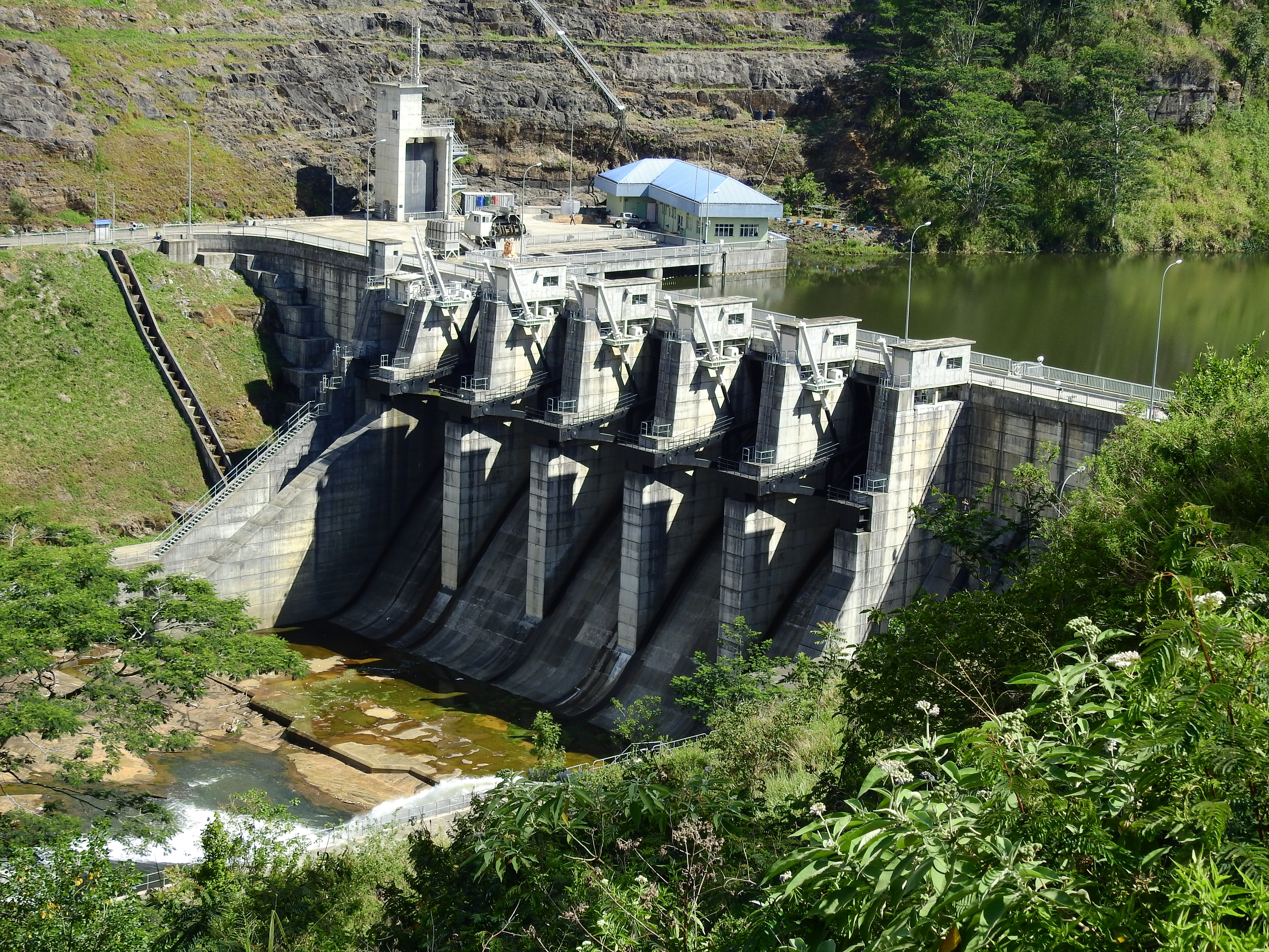
2. About Upper Kotmale Dam
- Location: Talawakele, Central Province, Sri Lanka
- Coordinates: 6.946871 N, 80.658179 E
- Type: Dam (hydraulic structure)
- Height: 35 m
The Upper Kotmale Dam sits on the Kotmale River, a tributary of the Mahaweli River, at the heart of Sri Lanka’s tea‑growing highlands. Though modest in height (35 m), the dam plays a vital role in regulating water flow for downstream irrigation and hydro‑electric projects. Its concrete gravity design blends seamlessly with the surrounding tea estates and forested slopes, creating a striking visual contrast between the sleek structure and the verdant hills.
Built as part of the country’s broader water‑resource development, the dam is also a quiet reminder of Sri Lanka’s commitment to sustainable energy and agricultural stability. Visitors can walk along the perimeter walkway, snap photos of the spillway against a backdrop of mist‑shrouded peaks, and feel the gentle hum of water coursing through the turbines—an experience that feels both industrial and intimately natural.
For a deeper dive into its history and technical details, check the official Wikipedia entry: Upper Kotmale Dam.
3. How to Get There
By Air
The nearest international gateway is Bandaranaike International Airport (CMB) near Colombo. From the airport, you have two main options:
| Mode | Approx. Time | Notes |
|---|---|---|
| Private car / Taxi | 4–5 hrs | Direct via the A1 (Colombo–Kandy) and A7 highways. |
| Domestic flight to Kandy + car hire | 1 hr (flight) + 2 hrs (drive) | Faster but depends on flight schedules. |
By Train
Sri Lanka’s scenic rail network is a favorite among travelers. Take the Kandy–Nuwara Eliya line (often called the “Hill Country Train”) from Kandy Railway Station to Talawakele Station. The journey lasts about 2 hours and offers spectacular views of tea plantations, misty valleys, and distant mountains. From Talawakele, the dam is a short 3 km (≈10 min) drive or a pleasant 45‑minute walk along the road.
By Bus
Intercity buses run frequently from Kandy and Nuwara Eliya to Talawakele. Look for routes labeled “Talawakele” or “Upper Kotmale.” Once you arrive in town, local tuk‑tuks or songthaews can drop you off at the dam’s visitor parking area.
By Car / Self‑Drive
If you prefer flexibility, rent a car in Colombo or Kandy and follow the A1 to Kandy, then the A7 north toward Gampola → Nawalapitiya → Talawakele. The road is well‑maintained, with plenty of tea‑estate viewpoints for impromptu photo stops.
Pro tip: The dam’s exact coordinates (6.946871, 80.658179) work perfectly with most GPS apps, ensuring you never miss the turn‑off.
4. Best Time to Visit
Sri Lanka’s central highlands enjoy a moderate climate year‑round, but the following periods give you the most rewarding experience:
| Season | Weather | Why Visit |
|---|---|---|
| December – February | Cool, dry, clear skies | Ideal for panoramic photography and comfortable walks. |
| April – May | Light showers, vibrant greenery | Water levels rise, creating a more dramatic spillway view. |
| September – October | Slightly cooler, occasional mist | Perfect for catching sunrise over the dam with a soft, ethereal backdrop. |
Avoid the peak monsoon months of June–August if you prefer dry conditions; heavy rain can make the surrounding roads slippery and reduce visibility of distant landmarks.
5. What to Expect
Scenic Views
The dam’s concrete wall stretches across the river, punctuated by a wide spillway that glistens under the sun. From the main observation deck, you can see the river winding through a deep gorge, framed by tea‑plantation terraces that cascade down the slopes.
Gentle Sounds
Even though the dam is functional, the water flow is relatively calm, creating a soothing background hum. It’s a perfect spot for meditation, a quiet picnic, or simply a moment of reflection amid nature.
Wildlife & Flora
The surrounding forest reserve hosts a variety of birds—kingfishers, egrets, and occasional raptors. During the early morning, you may spot small mammals such as the endemic Sri Lankan shrew or hear the distant call of the blue magpie.
Visitor Facilities
- Parking: Small lot near the entrance (free for cars, modest fee for larger vehicles).
- Restrooms: Clean, gender‑separated facilities close to the observation area.
- Information Board: Provides brief details on the dam’s purpose, construction, and safety guidelines.
6. Nearby Attractions
The Upper Kotmale Dam is a perfect hub for exploring several spectacular waterfalls and natural sites, all within a short drive.
| Attraction | Distance from Dam | Highlights | Link |
|---|---|---|---|
| St. Clair Falls | 1.2 km | A graceful cascade that plunges into a clear pool; great for a quick dip (if safe). | St. Clair Falls |
| Devon Watrefall | 3.2 km | A lesser‑known waterfall tucked behind tea bushes; ideal for photography lovers. | Devon Watrefall |
| Pundalu Oya (Dunsinane) Ella Falls | 7.3 km | A multi‑tiered waterfall that creates a misty rainbow on sunny days. | Pundalu Oya Ella Falls |
| Nearby Dam #1 | 7.6 km | Another hydro‑structure offering scenic viewpoints; perfect for dam‑enthusiasts. | (No dedicated page – local signage provides information.) |
| Nearby Dam #2 | 8.7 km | Small concrete dam surrounded by tea estates; great for a quiet stroll. | (No dedicated page – ask locals for directions.) |
Tip: Combine the dam visit with a waterfall tour in a single day. Start early at Upper Kotmale, head to St. Clair Falls for a morning coffee by the water, then make your way to Devon Watrefall and finish with the spectacular Pundalu Oya Ella Falls in the late afternoon when the light is golden.
7. Travel Tips
| Tip | Details |
|---|---|
| Dress for the hills | Light layers, a wind‑breaker, and sturdy walking shoes are advisable. Temperatures can drop to 15 °C (59 °F) in the early morning. |
| Carry cash | While larger towns accept cards, small vendors near the waterfalls often operate on cash only (Sri Lankan rupees). |
| Stay hydrated | Even in cooler weather, the altitude can cause mild dehydration. Bring a reusable water bottle. |
| Respect the environment | Do not litter; use the provided bins. The area is a protected watershed, so avoid washing dishes or swimming in restricted zones. |
| Photography gear | A wide‑angle lens captures the dam’s expanse, while a telephoto lens works well for distant waterfall details. A polarizing filter reduces glare on the water surface. |
| Timing for waterfalls | Water flow is strongest after a night of rain, making the falls more impressive. Check local weather forecasts the night before. |
| Local cuisine | Stop at a nearby tea estate’s canteen for a fresh “kiribath” (milk rice) or a cup of Ceylon tea—perfect after a hike. |
| Safety | Stick to marked paths, especially near the spillway. The concrete surface can be slippery when wet. |
Wrap‑Up
The Upper Kotmale Dam may not be as famous as Sri Lanka’s ancient citadels, but it offers a unique blend of engineering marvel, natural serenity, and easy access to some of the island’s most enchanting waterfalls. Its location in the heart of the Central highlands makes it an ideal stop for travelers exploring the tea country, seeking photo‑ops, or simply craving a peaceful spot away from the crowds.
Pack your camera, lace up your walking shoes, and let the gentle rush of the Kotmale River guide you through an unforgettable Sri Lankan adventure. Safe travels!