Kotmale Dam – A Majestic Engineering Marvel in the Heart of Sri Lanka’s Central Province
If you’re planning a Sri Lanka travel itinerary that blends awe‑inspiring engineering with lush mountain scenery, the Kotmale Dam should sit at the top of your list. Nestled near Gampola in the Central Province, this 87‑metre‑high concrete gravity dam not only powers the nation but also offers visitors a striking backdrop for photography, picnics, and exploration of nearby waterfalls. In this guide we’ll dive into the history, how to get there, the best time to visit, what you’ll experience on site, and the hidden natural gems just a short drive away.
1. About Kotleaf Dam
A Brief Description
- Name: Kotmale Dam
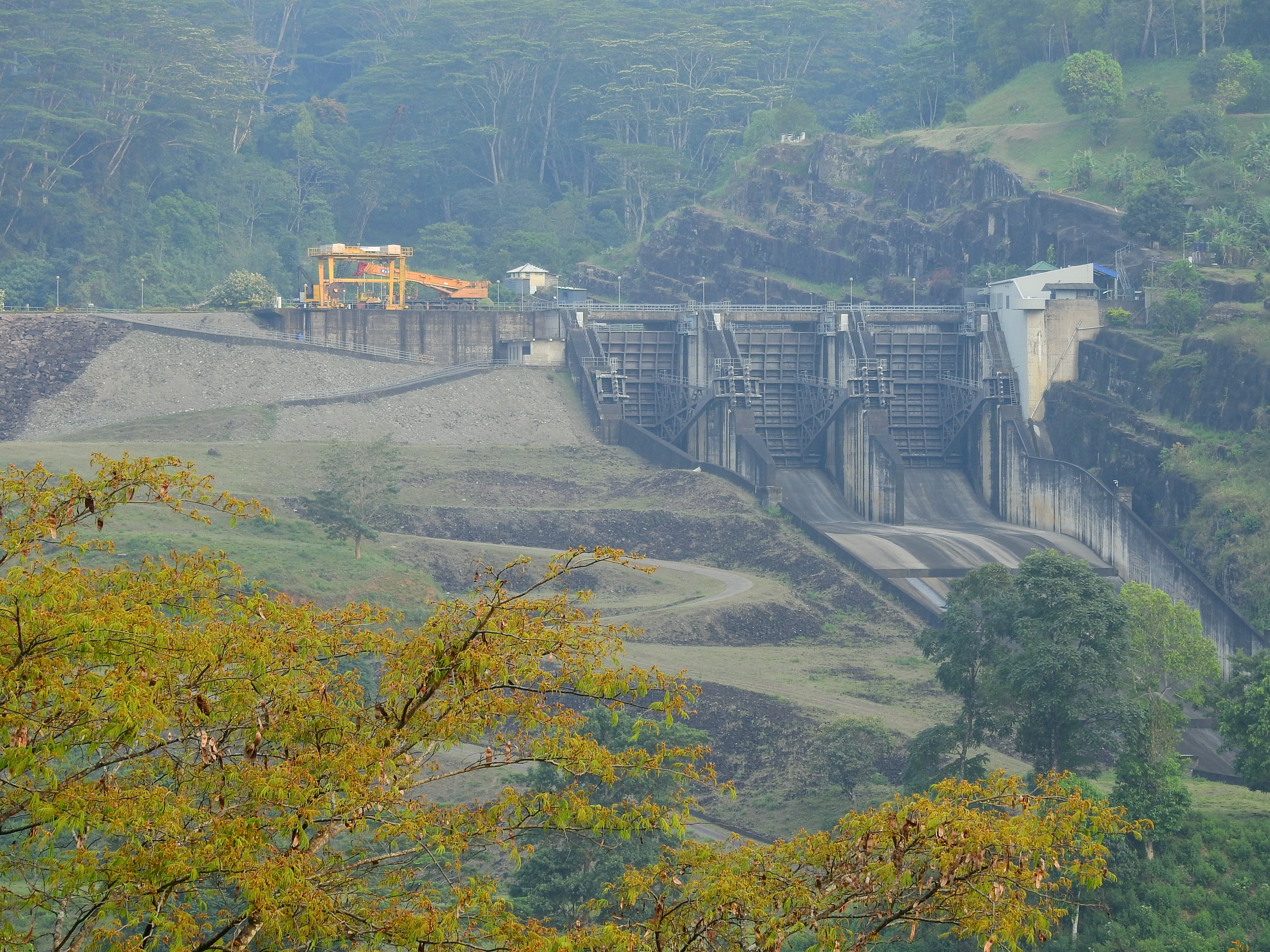
- Type: Concrete gravity dam 🏗️
- Location: Gampola, Central Province, Sri Lanka
- Coordinates: 7.060875° N, 80.597280° E
- Height: 87 m
The Kotmale Dam is part of the Mahaweli Development Programme, Sri Lanka’s largest multipurpose river‑valley project. Constructed across the Kotmale River, a tributary of the Mahaweli, the dam creates a sizeable reservoir that feeds the Kotmale Hydroelectric Power Station, contributing significantly to the country’s renewable energy mix.
A Slice of History
The dam’s construction began in the late 1970s as the nation sought to boost electricity generation and improve irrigation for agriculture. Despite the engineering challenges posed by the rugged terrain of the Central Highlands, the project was completed in the early 1990s, marking a milestone in Sri Lanka’s modern infrastructure development. Today, the dam stands as a testament to the country’s ambition to harness natural resources responsibly.
Why It Matters
Beyond power generation, Kotmale Dam plays a vital role in flood control, water supply for downstream irrigation, and tourism. Its reservoir, framed by mist‑clad hills, creates a tranquil setting that attracts locals and travelers alike. The dam also serves as an educational site where school groups learn about hydro‑technology and environmental stewardship.
For a deeper dive into the dam’s technical details, check the Kotmale Dam Wikipedia page.
2. How to Get There
By Air
The nearest international gateway is Bandaranaike International Airport (CMB), located about 140 km southwest of Kotmale Dam. From the airport, you can hire a private car or catch a domestic flight to Kandy, then continue by road.
By Train
Sri Lanka’s scenic railway network connects Colombo and Kandy with regular services. Disembark at Kandy Railway Station and take a taxi or local bus heading toward Gampola. The train ride itself is a picturesque experience, winding through tea‑covered slopes and verdant valleys.
By Road
- From Colombo: The drive is roughly 115 km via the A1 (Colombo‑Kandy) and A26 highways. Expect a 3‑hour journey, depending on traffic.
- From Kandy: It’s a shorter 45‑km trip (about 1 hour) heading east on the A26 toward Gampola, then following local signs to the dam.
- From Gampola: The dam sits just a few kilometres outside town; you can reach it by hiring a tuk‑tuk, renting a scooter, or using a rideshare app.
Public Transport Tips
- Buses: Intercity buses run frequently between Colombo, Kandy, and Gampola. From Gampola, local minibusses (known as “daladala”) head toward the dam area.
- Tuk‑tuk: For flexibility and a chance to soak up the countryside, negotiate a tuk‑tuk fare from Gampola to the dam.
Pro tip: Carry a printed copy of the coordinates (7.060875, 80.597280) for navigation apps, especially if you’re driving a rental car.
3. Best Time to Visit
Sri Lanka’s climate is tropical, but the Central Province experiences cooler temperatures and distinct wet and dry periods.
| Season | Weather | Why Visit |
|---|---|---|
| December – March | Dry, sunny, cooler evenings (15‑22 °C) | Ideal for clear views of the dam and surrounding hills. |
| April – May | Pre‑monsoon, occasional showers | Lush greenery; fewer crowds. |
| June – September | Southwest monsoon (rainier) | Water levels high—great for spotting the reservoir’s full expanse. |
| October – November | Inter‑monsoon, moderate rain | Photographers love the misty atmosphere. |
Recommendation: The December‑March window offers the most reliable weather for outdoor activities and photography, while the June‑September period provides dramatic, water‑filled scenery for those who don’t mind a light drizzle.
4. What to Expect
Scenic Views
Approaching Kotmale Dam, you’ll be greeted by the massive concrete wall stretching across the river, framed by emerald hills that rise dramatically on either side. The reservoir mirrors the sky, creating perfect reflection shots at sunrise and sunset.
Visitor Facilities
- Viewing Platforms: Designated spots allow safe, unobstructed views of the spillway and water flow.
- Picnic Areas: Small benches and grassy patches are ideal for a quick snack.
- Information Boards: Basic details about the dam’s construction, capacity, and environmental impact are displayed in both Sinhala and English.
Activities
- Photography: Capture the contrast between industrial engineering and natural beauty.
- Birdwatching: The reservoir attracts waterfowl and migratory species.
- Leisure Walks: A short, well‑maintained path circles part of the dam, perfect for a leisurely stroll.
Safety
The dam area is secured, and visitors are expected to stay within marked zones. Swimming or boating in the reservoir is prohibited without official permission. Always follow local signage and respect any temporary closures for maintenance.
5. Nearby Attractions
After soaking in the grandeur of Kotmale Dam, venture a short distance to discover a cluster of enchanting waterfalls—each offering its own charm.
| Attraction | Distance from Dam | Highlights |
|---|---|---|
| [Unnamed Waterfall] | 7.2 km | A secluded cascade surrounded by dense foliage. |
| Garandi Gini Ella | 10.8 km | Known for its tiered flow and crystal‑clear pool. |
| Gerandi Ella Waterfall | 11.0 km | A picturesque drop that creates a misty rainbow on sunny days. |
| [Unnamed Waterfall] | 11.0 km | Ideal for a quick photo stop on the way back. |
| Dewathura Ella | 11.2 km | Features a gentle curtain of water that’s perfect for picnics. |
Tip: Many of these falls are accessible via local roads and short hiking trails. Consider hiring a local driver or joining a guided day‑trip that bundles the dam with the waterfalls for a hassle‑free experience.
6. Travel Tips
- Start Early: Arriving at sunrise not only guarantees cooler temperatures but also offers the best lighting for photography.
- Dress Comfortably: Light layers work well—mornings can be cool, while afternoons warm up. Pack a rain jacket if traveling during the monsoon.
- Stay Hydrated: Carry water, especially if you plan to hike to nearby waterfalls.
- Cash on Hand: Small vendors near the dam may only accept cash; keep some Sri Lankan rupees handy.
- Respect the Environment: Use designated trash bins and avoid littering. The area’s natural beauty depends on responsible tourism.
- Check Road Conditions: During heavy rains, mountain roads can become slippery. Verify the status of local routes before heading out.
- Local Etiquette: Greet locals with a friendly “Ayubowan” (hello) and ask permission before taking close‑up photos of people.
7. Wrap‑Up: Why Kotmale Dam Belongs on Your Sri Lanka Bucket List
Kotmale Dam isn’t just a functional piece of infrastructure; it’s a striking landmark where engineering meets the raw beauty of Sri Lanka’s Central Highlands. From its panoramic views and tranquil reservoir to the cascade of waterfalls just a short drive away, the site offers a well‑rounded day trip for nature lovers, photography enthusiasts, and curious travelers alike.
Combine a visit to the dam with a scenic drive through tea‑plantation valleys, stop for a cup of Ceylon tea in a roadside stall, and you’ll experience the authentic charm that makes Sri Lanka a top destination for adventure and cultural immersion.
Pack your camera, map out your route, and let the roar of the water and the hum of the turbines guide you into one of the island’s most unforgettable experiences. Safe travels!