Discover the Power and Beauty of Barrage hydro‑électrique de Peligre
Your ultimate guide to Haiti’s iconic dam and the hidden gems surrounding it
Introduction
If you think Haiti is only about vibrant music, historic forts, and sun‑kissed beaches, think again. Nestled in the rolling hills of the Centre department, the Barrage hydro‑électrique de Peligre (commonly known as the Péligré Dam) stands as a testament to engineering ambition and natural splendor. Whether you’re a road‑trip enthusiast, a photography junkie, or a curious traveler eager to explore off‑the‑beaten‑path sites, this hydroelectric dam offers a striking blend of industrial heritage and breathtaking scenery that’s impossible to ignore.
About Barrage hydro‑électrique de Peligre
- Location: Mirebalais, Centre, Haiti
- Coordinates: 18.900626, -72.039546
- Type: Hydroelectric dam 🏗️
- Height / Altitude: Information not publicly disclosed
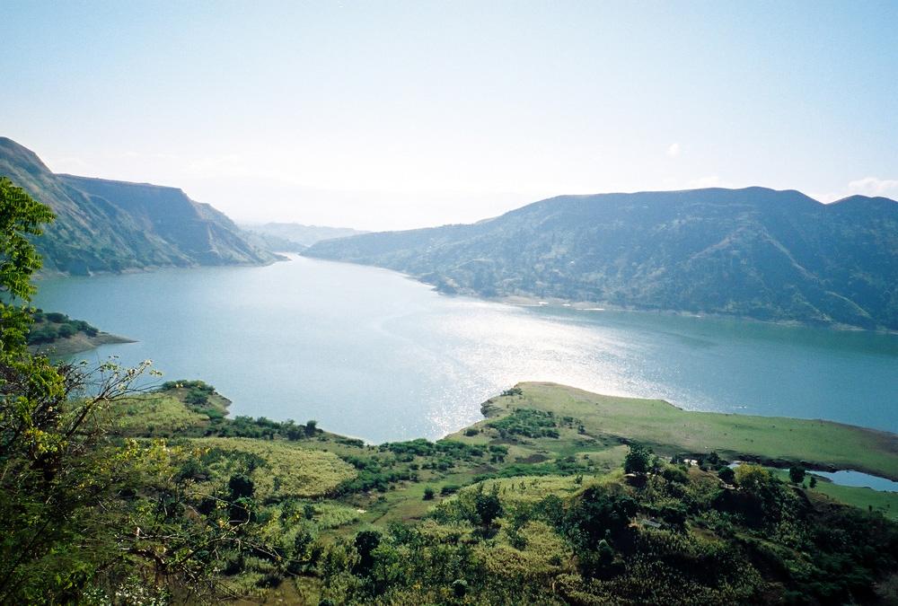
Built in the 1970s, the Péligré Dam was created to harness the flow of the Rivière Artibonite, Haiti’s longest river, and generate much‑needed electricity for the nation’s central plateau. The reservoir, often called Lake Péligré, stretches over 12 km², forming a shimmering blue mirror that reflects the surrounding mountains and agricultural fields.
Historical Significance
The dam’s construction marked a pivotal moment in Haiti’s development strategy, aiming to reduce reliance on imported fossil fuels and stimulate rural electrification. While the project faced challenges—ranging from funding constraints to environmental concerns—it ultimately became a cornerstone of Haiti’s energy infrastructure. Today, the dam supplies power to thousands of homes and businesses in the Centre department and beyond, making it a critical piece of the country’s economic puzzle.
Why It Matters to Travelers
Beyond its functional role, the Péligré Dam offers a unique glimpse into Haiti’s modern history and its ongoing relationship with nature. The site is a perfect backdrop for:
- Panoramic photography of the reservoir and surrounding hills.
- Educational tours that explain hydroelectric technology in a Caribbean context.
- Quiet contemplation along the water’s edge, far from the bustling streets of Port‑au‑Prince.
How to Get There
By Air & Ground
- Fly into Toussaint Louverture International Airport (Port‑au‑Prince). Most international visitors land here.
- Rent a car or arrange a private driver. The most reliable way to reach Mirebalais is via the RN3 highway, which runs east‑west across the Centre department.
- Drive to the dam:
- From Port‑au‑Prince, follow the RN3 eastward for roughly 80 km (about 1.5 hours).
- Turn onto the Péligré Road (signposted for “Barrage de Péligré”) and continue for 10 km until you see the reservoir and dam signage.
Public Transportation
- Shared taxis (tap‑tap) operate between Port‑au‑Prince and Mirebalais. Ask the driver to drop you off at the “Barrage” stop; you may need to walk a short distance or arrange a local motorbike (moto) ride to the exact viewpoint.
- Local buses from Mirebalais town center run a few times a day toward the dam, but schedules can be irregular, so confirm timings locally.
Parking & Accessibility
A modest parking lot sits near the main visitor area, offering space for cars and motorcycles. The site is wheelchair‑friendly up to the viewing platform, though the terrain beyond can be uneven.
Best Time to Visit
| Season | Weather | Travel Recommendation |
|---|---|---|
| Dry Season (Nov – Apr) | Warm, clear skies, low rainfall | Peak visitor period – ideal for photography, hiking, and uninterrupted views of the reservoir. |
| Rainy Season (May – Oct) | Frequent showers, occasional thunderstorms | Still visitable, but expect mist over the water and slippery paths. Early mornings are usually clearer. |
Tip: The dam’s water level fluctuates with the rainy season. Late spring (April–May) often offers the most dramatic contrast between the full reservoir and the surrounding hills.
What to Expect
Visual Experience
- Expansive Reservoir: The lake’s turquoise surface stretches to the horizon, punctuated by fishing boats and occasional local swimmers.
- Engineering Marvel: The concrete spillway and turbine house are visible from the main viewpoint, offering a rare glimpse of functional infrastructure amidst natural beauty.
- Mountain Backdrop: The surrounding Mirebalais hills provide a dramatic silhouette, especially at sunrise and sunset.
Activities
- Guided Tours: Local guides (often hired through the dam’s administration office) can explain the hydroelectric process, the dam’s history, and its impact on the region.
- Birdwatching: The reservoir attracts waterfowl, kingfishers, and occasional migratory species. Bring binoculars for a rewarding experience.
- Picnic Spots: Designated grassy areas near the water allow for a relaxing lunch while you soak in the scenery.
Amenities
- Restrooms: Basic facilities are available near the visitor center.
- Refreshments: Small kiosks sell bottled water, fresh fruit juices, and local snacks like “marinad” (fried plantains).
- Souvenirs: Hand‑crafted items from Mirebalais artisans (woven bags, wooden carvings) can be purchased at a nearby market stall.
Nearby Attractions
After exploring the dam, broaden your itinerary with these natural gems—each a short drive away and perfect for a day‑trip or quick stop.
| Attraction | Distance from Dam | Highlights |
|---|---|---|
| [Spring] | 10.9 km | A crystal‑clear spring ideal for a refreshing dip. |
| Source Mondesir (spring) | 12.8 km | Known locally for its mineral‑rich waters and serene forest setting. |
| [Spring] | 12.8 km | Secluded spot surrounded by tropical foliage—great for photography. |
| [Spring] | 14.0 km | A tranquil waterfall-fed pool, perfect for a picnic. |
| [Spring] | 15.0 km | Offers panoramic views of the surrounding valley and a chance to spot local wildlife. |
Note: The exact names of some springs are not widely documented, but they are marked on local maps and easily reachable via paved roads. Ask a resident or your driver for directions; locals are friendly and love sharing hidden spots.
Travel Tips
- Carry Cash (HTG or USD). ATMs are scarce near the dam; small vendors prefer cash.
- Stay Hydrated & Sun‑Protected. Even in the dry season, the Haitian sun can be intense. Bring a hat, sunscreen, and plenty of water.
- Learn Basic Creole Phrases. Simple greetings like “Bonjou” (Good morning) and “Mèsi” (Thank you) go a long way.
- Respect Local Customs. Dress modestly when visiting nearby villages and always ask permission before photographing residents.
- Safety First. While the area is generally safe for tourists, avoid wandering alone after dark and keep valuables out of sight.
- Check Road Conditions. Heavy rains can make rural roads muddy. If traveling during the rainy season, allow extra travel time.
- Support the Community. Purchase snacks, crafts, or guided tours from local providers—your money helps sustain the region’s economy.
- Bring a Portable Charger. Power can be intermittent in rural Haiti; a power bank ensures your phone stays alive for navigation and photos.
Wrap‑Up
The Barrage hydro‑électrique de Peligre is more than a functional dam; it’s a gateway to Haiti’s lesser‑known landscapes, a living classroom on renewable energy, and a serene spot for travelers seeking authenticity. Pair your visit with the nearby springs, indulge in local flavors, and you’ll leave with a deeper appreciation for the country’s resilience and natural beauty.
Ready to add the Péligré Dam to your Haitian adventure? Pack your camera, hit the road, and let the rhythm of the Artibonite River guide you to an unforgettable experience. 🌊🏞️
