Barragem de Capanda – Angola’s Hidden Hydroelectric Gem
Explore the towering dam, stunning scenery, and off‑the‑beaten‑path attractions of Cuanza Norte.
Introduction
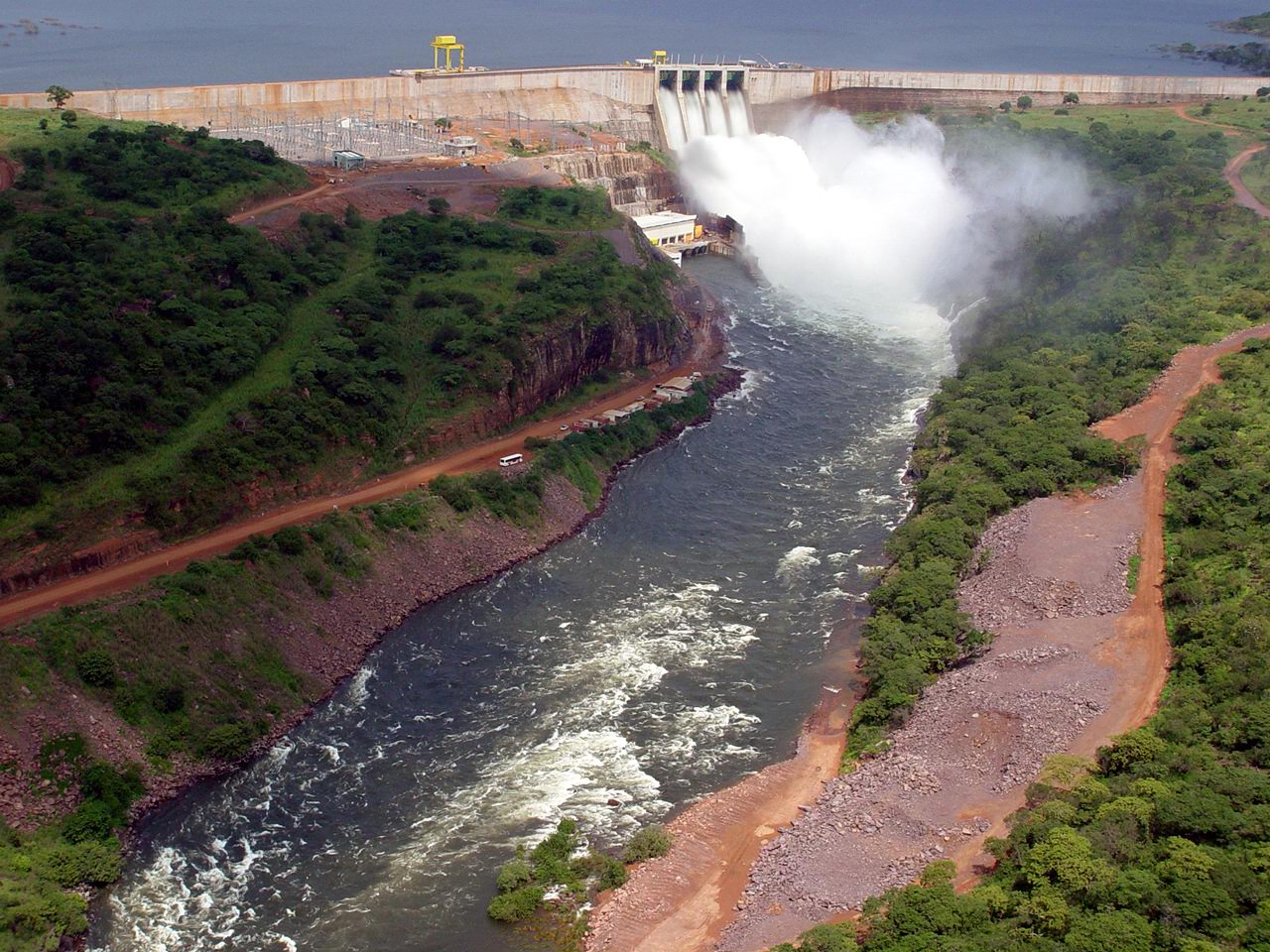
If you think Angola’s travel highlights are limited to Luanda’s bustling streets or the pristine beaches of the Atlantic coast, think again. Nestled in the rolling hills of Cuanza Norte, the Barragem de Capanda (also known as the Capanda Dam) rises 110 metres above the Kwanza River, forming a dramatic backdrop for adventurous travelers and eco‑enthusiasts alike. This impressive hydro‑electric structure isn’t just a feat of engineering; it’s a gateway to a region where rugged landscapes, quiet villages, and neighboring dams create a unique “dam‑tour” experience you won’t find anywhere else in Southern Africa.
In this guide we’ll dive into the history and significance of the Capanda Dam, show you how to reach it, tell you the best time to visit, and highlight nearby attractions that make a day‑trip around the dam worth planning. Whether you’re a photographer hunting striking vistas, a traveler interested in Angola’s energy story, or simply looking for an off‑the‑radar destination, read on for the ultimate Barragem de Capanda travel itinerary.
About Barragem de Capanda
A Brief Overview
- Name: Barragem de Capanda
- Type: Hydroelectric dam 🏗️
- Location: N’dalatando, Cuanza Norte, Angola
- Coordinates: -9.795652, 15.465500
- Height: 110 m
The dam forms part of the Capanda Hydroelectric Power Station, a cornerstone of Angola’s post‑war reconstruction and energy diversification. While the exact altitude of the reservoir isn’t publicly listed, the surrounding plateau sits at a comfortable mid‑elevation, offering cool breezes and sweeping views of the Kwanza River valley.
Historical Context
Built after Angola’s civil war, the Capanda project was a joint effort involving Angolan authorities and international partners. Its primary goal was to generate clean, renewable electricity for the nation’s growing grid, reducing reliance on fossil fuels and supporting industrial development. The dam’s construction marked a turning point in the country’s infrastructure landscape, symbolising resilience and forward momentum.
Why It Matters
Beyond power generation, the Barragem de Capanda has become a tourist attraction for several reasons:
- Engineering Marvel: At 110 m high, the concrete gravity dam showcases modern engineering set against a natural backdrop.
- Scenic Reservoir: The expansive lake created by the dam reflects the surrounding hills, providing perfect sunrise and sunset photo opportunities.
- Cultural Touchpoint: Nearby villages celebrate traditional Angolan music, cuisine, and crafts, offering visitors a glimpse into local life.
- Ecotourism Potential: The reservoir and river support a variety of bird species and fish, making it a subtle hotspot for wildlife watchers.
For a deeper dive into the dam’s technical details, check the Portuguese‑language Wikipedia entry: Central Hidroelétrica de Capanda.
How to Get There
By Air
The nearest major airport is Luanda International Airport (LAD), located roughly 300 km southwest of the dam. From Luanda, you can catch a domestic flight to N’dalatando Airport (NDD), which serves the provincial capital and sits just 15 km north of the dam site. Several Angolan airlines operate this route daily.
By Road
If you prefer a road adventure, the journey is scenic and relatively straightforward:
- From Luanda: Take the EN120 highway northward toward Caxito. Continue on EN120 until you reach the junction for EN230, which leads directly to N’dalatando.
- From N’dalatando: Follow the local road signs for “Barragem de Capanda” or use GPS coordinates –9.795652, 15.465500 – to navigate the final 10 km. The road is paved but can be dusty during the dry season, so a high‑clearance vehicle is advisable.
Public Transport
Mini‑buses (known locally as “carrinhas”) run regularly between Luanda, Caxito, and N’dalatando. From the N’dalatando bus station, you can hire a shared taxi or a motorbike (“moto”) to the dam. Expect the ride to take about 30 minutes from the town center.
Driving Tips
- Fuel: Fill up in Luanda or Caxito; fuel stations become sparse after Caxito.
- Road Conditions: The last stretch may have potholes after heavy rains; drive cautiously.
- Navigation: Offline maps (e.g., MAPS.ME) are useful where mobile data is limited.
Best Time to Visit
Angola’s climate is tropical with two main seasons: a wet season (November–April) and a dry season (May–October).
| Season | Weather | Why Visit? |
|---|---|---|
| Dry Season (May‑Oct) | Warm days (25‑30 °C), clear skies, low humidity | Ideal for photography, hiking, and safe road conditions. The reservoir’s water level remains stable, offering clear views of the dam’s structure. |
| Wet Season (Nov‑Apr) | Frequent showers, higher humidity, occasional thunderstorms | The river swells, creating dramatic water flow and lush green surroundings—great for birdwatchers and those who love vibrant landscapes. Some roads may become slippery, so plan extra travel time. |
Peak Visitor Window: Late June to early September provides the best balance of pleasant weather and optimal lighting for sunrise/sunset shots of the dam.
What to Expect
The Visual Experience
Approaching the dam, the first thing you’ll notice is the sheer height of the concrete wall cutting across the river. From the main viewing platform (a modest, well‑maintained spot near the control house), you can walk right up to the spillway and feel the power of the water rushing through the turbines. The reservoir stretches out like a glassy mirror, reflecting the surrounding hills and, on clear days, the distant Barragem do Laúca dam.
Sounds & Sensations
- Water Roar: The turbines generate a low, constant hum, punctuated by the occasional splash of water over the spillway.
- Birdsong: Early mornings bring a chorus of local bird species—kingfishers, weavers, and occasional raptors soaring above the lake.
- Local Life: Small fishing boats glide across the reservoir, and you may hear villagers calling out greetings in Kimbundu or Portuguese.
Activities
- Photography: Capture the dam at sunrise when the light paints the concrete in golden hues.
- Guided Tours: While formal visitor centers are limited, local guides often offer short walks explaining the dam’s operation and the region’s history.
- Picnicking: The grassy banks near the reservoir are perfect for a relaxed lunch—just remember to bring your own waste bags as facilities are minimal.
Nearby Attractions
A visit to Barragem de Capanda can easily become a mini‑road‑trip through Cuanza Norte’s hydro‑tourism corridor. Below are the most accessible spots within a 40 km radius:
| Attraction | Distance from Capanda | Type | Highlights |
|---|---|---|---|
| Unnamed Dam (30.8 km) | 30.8 km | Dam | Small reservoir, quiet fishing spot. |
| Unnamed Dam (31.0 km) | 31.0 km | Dam | Scenic viewpoint of river bends. |
| Unnamed Rapids (36.4 km) | 36.4 km | Rapids | Ideal for adventurous water‑play (observe safety). |
| Unnamed Dam (36.4 km) | 36.4 km | Dam | Offers a contrasting design to Capanda. |
| Barragem do Laúca | 37.7 km | Dam | One of Angola’s largest dams; impressive height and visitor area. |
Note: While the unnamed sites don’t have dedicated tourism webpages, they can be located using GPS coordinates or by asking locals in N’dalatando. For more information on the Barragem do Laúca, you can visit its official page or the Angolan Ministry of Energy’s site.
Suggested Day‑Trip Route:
- Start at Barragem de Capanda for sunrise photos.
- Drive east to the 30.8 km dam for a quick stop and a local snack.
- Continue to the rapids (36.4 km) for a short hike and birdwatching.
- End the day at Barragem do Laúca, where you can enjoy a sunset over the largest reservoir in the region.
Travel Tips
| Tip | Details |
|---|---|
| Currency | Angolan Kwanza (AOA). ATMs are scarce outside Luanda; carry cash. |
| Language | Portuguese is the official language; basic Kimbundu phrases are appreciated. |
| Safety | The area is generally safe for tourists, but keep valuables out of sight and travel in groups after dark. |
| Health | Bring malaria prophylaxis and insect repellent; drink only bottled or filtered water. |
| Dress Code | Light, breathable clothing for daytime; a light jacket for evenings (especially in the dry season). |
| Photography Gear | A wide‑angle lens captures the dam’s scale; a polarizing filter reduces glare on the water. |
| Local Etiquette | Ask permission before photographing people, especially in villages. |
| Connectivity | Mobile coverage improves near N’dalatando; consider a local SIM for maps and translation apps. |
| Respect the Environment | Pack out all trash, stay on marked paths, and avoid disturbing wildlife. |
| Permits | No special permits are required for visiting the dam, but a small entry fee may apply for the viewing platform. |
Final Thoughts
Barragem de Capanda may not yet be on every traveler’s bucket list, but its blend of engineering grandeur, natural beauty, and authentic Angolan culture makes it a hidden treasure worth discovering. By timing your visit during the dry season, planning a flexible road itinerary, and respecting local customs, you’ll walk away with unforgettable images, fresh stories, and a deeper appreciation for Angola’s journey toward sustainable energy.
Pack your camera, fuel up the 4×4, and set your GPS to -9.795652, 15.465500—the Capanda Dam awaits. Safe travels!