Wairere Falls – New Zealand’s Majestic 153‑Metre Waterfall in Waikato
Discover the thundering beauty of Wairere Falls, the tallest waterfall in the North Island, and learn how to make the most of your visit to this natural wonder.
Introduction
Imagine standing at the base of a 153‑metre cascade, the roar of water echoing through native forest, mist kissing your skin, and the scent of fern and pine filling the air. That’s the unforgettable experience awaiting you at Wairere Falls, the highest waterfall in the North Island of New Zealand. Nestled near the charming town of Matamata in Waikato, this spectacular waterfall is a must‑see for hikers, photographers, and anyone craving a slice of untouched wilderness. In this guide we’ll dive into the history, the best ways to get there, optimal visiting times, what you’ll see on the trail, nearby attractions, and essential travel tips—so you can plan a flawless adventure to Wairere Falls.
About Wairere Falls
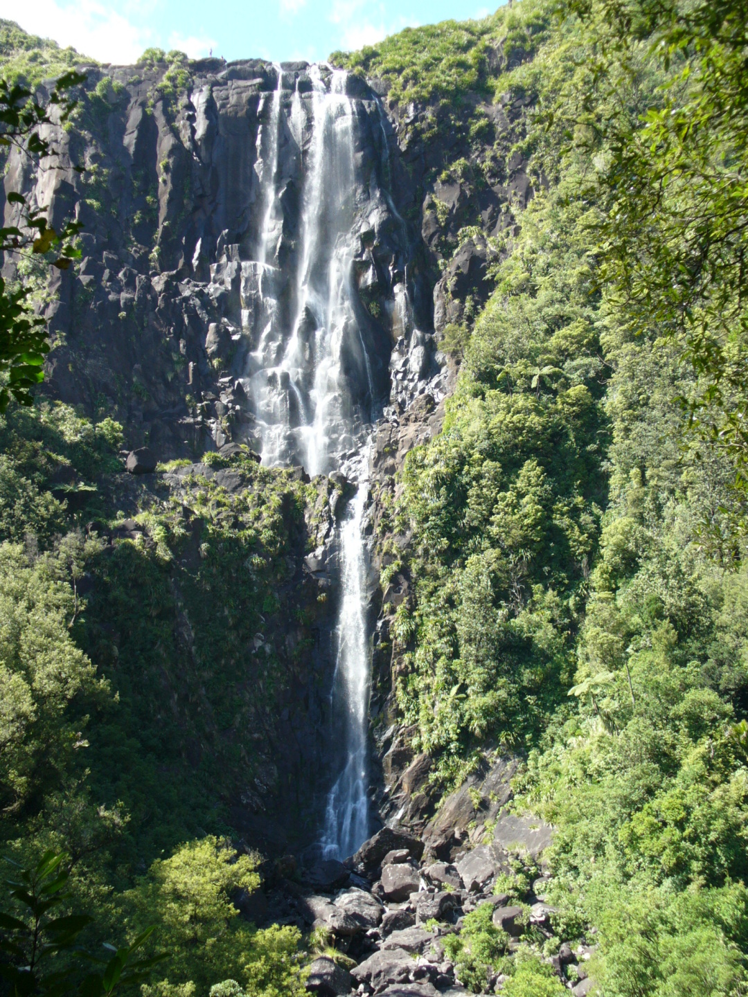
A towering natural landmark
Wairere Falls drops a dramatic 153 metres (502 ft) from the Wairere Plateau into the Waikato River valley. The waterfall is fed by the Wairere Stream, which tumbles over a series of basalt cliffs before plunging into the gorge below. Its sheer height makes it the tallest waterfall in the North Island, a fact that earns it a prominent spot on New Zealand’s waterfall map.
History and cultural significance
The name Wairere comes from the Māori language, meaning “waterfall” or “the sound of water”. The falls sit on land traditionally belonging to the Ngāti Huri hapū of the Waikato iwi, who have long regarded the site as a place of spiritual power. While the exact historical uses are not documented in detail, the surrounding forest was historically a source of food, timber, and fresh water for Māori travelers moving between the inland plateau and the coastal plains.
Why it matters today
Beyond its natural grandeur, Wairere Falls is a focal point for conservation and eco‑tourism in the region. The surrounding native forest is home to a variety of endemic birds such as the kererū (New Zealand pigeon) and kōkako, making the hike a rewarding bird‑watching opportunity as well. The waterfall’s popularity has helped promote the protection of the watershed and the preservation of the surrounding Waikato landscape.
How to Get There
By car
The most convenient way to reach Wairere Falls is by private vehicle. From Hamilton, the largest city in the Waikato region, follow State Highway 1 north to Matamata (≈ 70 km, 1‑hour drive). In Matamata, turn left onto Maraetotara Road (also known as Wairere Road) and follow the signs for the Wairere Falls car park. The total distance from Hamilton to the car park is roughly 85 km.
- Parking: A small, free car park sits at the trailhead. Arrive early in peak season (December–February) as spaces can fill quickly.
Public transport
Public transport options are limited. The nearest InterCity bus stop is in Matamata, from which you can catch a local taxi or rideshare to the trailhead (≈ 10 km).
Walking in from nearby towns
For the adventurous, you can combine a visit to Te Ariki Falls (1.7 km away) and walk the short forest tracks that link the two sites. However, the main access road remains the most practical entry point for most visitors.
Coordinates
- Latitude: -37.734190
- Longitude: 175.879570
Plug these into your GPS for precise navigation.
Best Time to Visit
| Season | Weather & Water Flow | Visitor Experience |
|---|---|---|
| Spring (Sep‑Nov) | Frequent rain showers swell the stream, creating a powerful flow. Temperatures mild (12‑18 °C). | Lush greenery, blooming native plants, fewer crowds than summer. |
| Summer (Dec‑Feb) | Warm, dry days (20‑25 °C). Water flow can be moderate. | Peak tourist season—longer daylight for photography, but expect busier trails. |
| Autumn (Mar‑May) | Cooler evenings, occasional rain. Water levels start to drop, revealing more rock texture. | Brilliant foliage colors, comfortable hiking temperatures, quieter paths. |
| Winter (Jun‑Aug) | Cooler (8‑12 °C) and potentially misty; water flow remains strong due to winter rains. | Dramatic mist over the falls, fewer visitors—ideal for a peaceful experience. |
Tip: The waterfall is spectacular year‑round, but for the most dramatic plunge, aim for late autumn or early spring when rainfall is still high but the weather is not overly hot.
What to Expect
The trail experience
The Wairere Falls Track is a well‑maintained, graded trail that starts at the car park and climbs roughly 300 m in elevation to the viewing platform.
- Distance: 2.5 km round‑trip (≈ 1 km each way).
- Difficulty: Moderate. The ascent includes several steep sections and a few short, exposed staircases. Good walking shoes and a walking pole are recommended.
- Scenery: As you ascend, the forest opens to reveal sweeping views of the Waikato River valley, native podocarp trees, and occasional glimpses of the Kaimai Range in the distance.
The viewing platform
At the summit, a sturdy wooden platform offers a panoramic vista of the waterfall’s full 153‑metre drop. On clear days, you can see the Matamata townscape and, far beyond, the rolling hills of the Coromandel Peninsula.
Wildlife & flora
- Birds: Keep an eye out for the kererū, kōkako, and pīwakawaka (fantail).
- Plants: Ferns, pōhutukawa seedlings, and the iconic kauri trees dominate the understory.
Safety notes
- The track can be slippery after rain; tread carefully on wet rocks.
- No swimming is allowed at the base of the falls due to strong currents and steep cliffs.
Nearby Attractions
After soaking in the majesty of Wairere Falls, extend your adventure with these nearby natural gems (all within a 10 km radius):
| Attraction | Type | Distance from Wairere Falls | Quick Note |
|---|---|---|---|
| Te Ariki Falls | Waterfall 🌊 | 1.7 km | A smaller cascade nestled in the same forest, perfect for a quick side‑trip. |
| Crystal Spring | Spring 💧 | 6.7 km | A crystal‑clear spring that feeds a tranquil pool—great for a peaceful picnic. |
| Opal Spring | Spring 💧 | 6.9 km | Known for its sparkling water and surrounding fern garden. |
| [Unnamed Fountain] | Fountain 💦 | 6.7 km | A charming ornamental fountain set in a small garden area. |
| [Unnamed Waterfall – Bay of Plenty] | Waterfall 🌊 | 8.0 km | A scenic waterfall just across the regional border, offering a different landscape vibe. |
All links lead to further information on each site (where available) and can be added to your itinerary for a full‑day nature tour.
Travel Tips
- Start Early – Arriving before 9 am in summer avoids the busiest periods and gives you softer light for photos.
- Pack Layers – Waikato weather can shift quickly; a lightweight rain jacket and a warm layer are essential.
- Stay Hydrated – Bring at least 1 L of water per person; there are no refill stations on the track.
- Leave No Trace – Pack out all litter, stay on marked paths, and respect the cultural significance of the area.
- Photography Hacks – Use a polarizing filter to reduce glare on the water, and try a low‑angle shot from the base of the falls for dramatic perspective.
- Wildlife Watching – Early morning or late afternoon are the best times to spot native birds. Remain quiet and move slowly.
- Accessibility – The trail is not wheelchair‑accessible due to steep sections, but the viewing platform offers a safe spot for those with limited mobility to enjoy the view from the top of the car park.
- Local Food – Stop in Matamata for a bite at the Farmside Café or try the famous Hangi at a local Māori cultural centre.
Final Thought
Wairere Falls is more than just a waterfall; it’s a living piece of New Zealand’s natural and cultural tapestry. Whether you’re chasing the perfect waterfall photo, seeking a moderate hike, or simply yearning for the soothing roar of water in a pristine forest, this 153‑metre cascade delivers an unforgettable experience. Plan your trip, respect the land, and let the mist of Wairere Falls refresh your spirit.
Ready to explore? Pack your boots, hit the road to Matamata, and let the adventure begin!