Saint Croix Falls Dam – A Hidden Wisconsin Gem Worth the Road Trip
If you’ve ever chased the perfect blend of engineering marvel, river‑side scenery, and small‑town charm, the Saint Croix Falls Dam in Wisconsin should be at the top of your itinerary. Nestled on the mighty St. Croix River, this historic dam offers more than just a glimpse into early 20th‑century power generation—it’s a gateway to a cluster of waterfalls, state parks, and outdoor adventures that make northern Wisconsin a year‑round playground.
About Saint Croix Falls Dam
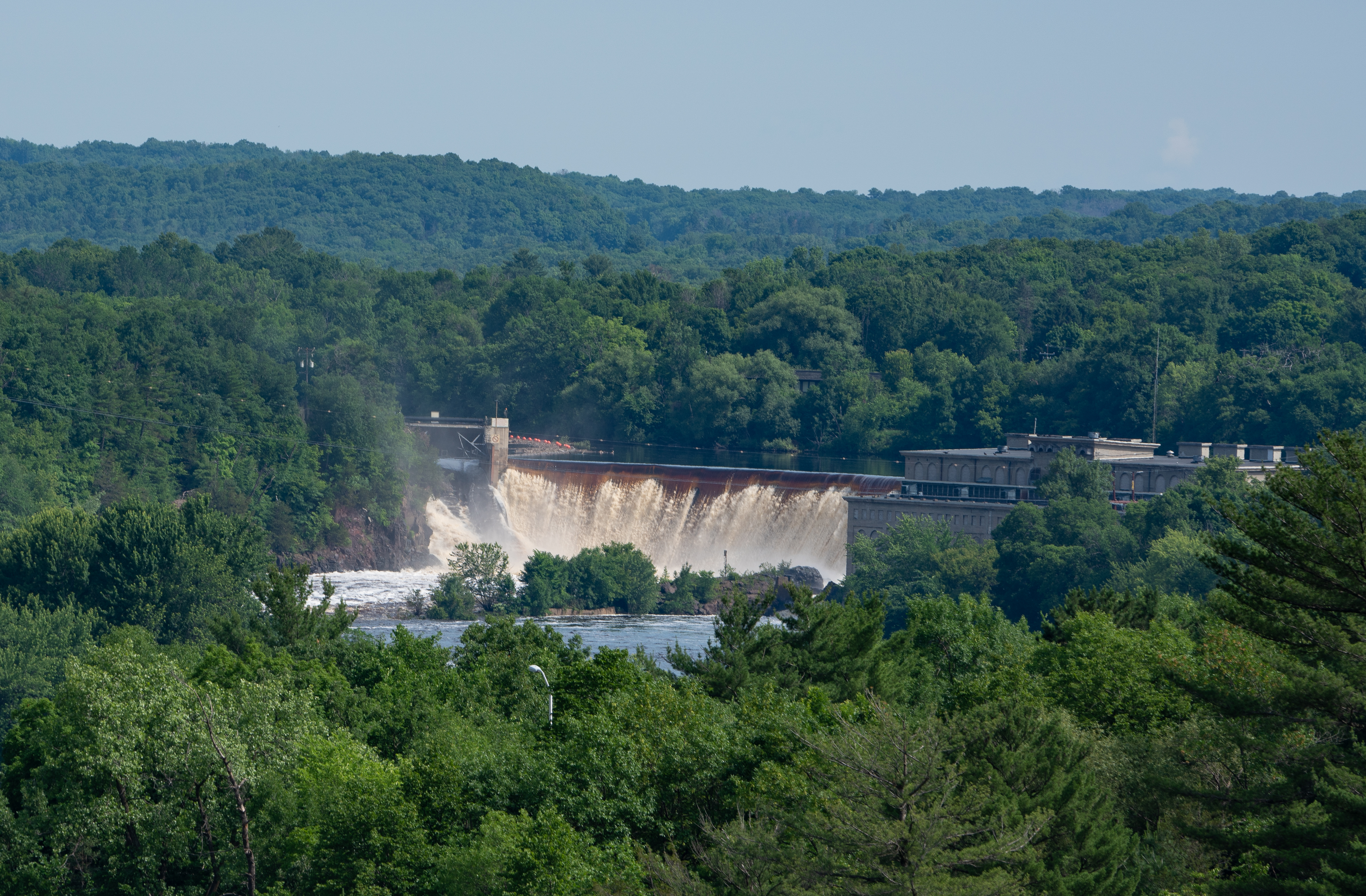
The Saint Croix Falls Dam is a hydroelectric dam situated in the village of Saint Croix Falls, Wisconsin, United States. Its coordinates are 45.412735, ‑92.647407, and it rests at an elevation of 208 m above sea level. While the exact height of the structure isn’t publicly listed, the dam’s presence is unmistakable: a concrete wall spanning the river, flanked by historic brick buildings that once housed the original power plant.
A Brief History
Constructed in the early 1900s, the dam was originally built to harness the St. Croix River’s flow for electricity, powering local industry and homes. Over the decades, the facility has been upgraded but still retains its classic architectural vibe—think red‑brick turbine houses and a sturdy spillway that echoes the engineering optimism of the era. Today, the dam continues to generate renewable energy while serving as a cultural landmark for the region.
Why It Matters
- Renewable Energy – The dam contributes clean hydroelectric power to the regional grid, underscoring Wisconsin’s commitment to sustainable energy.
- Historical Value – Its early‑20th‑century design offers a living museum for anyone interested in industrial heritage.
- Scenic Spot – Positioned where the river drops over a natural ledge, the dam creates a dramatic backdrop for photography, bird‑watching, and quiet contemplation.
If you’re curious for more technical details, the Wikipedia entry provides a solid overview: Saint Croix Falls Dam – Wikipedia.
How to Get There
By Car
The dam is conveniently located just off U.S. Highway 8 and Wisconsin State Highway 35. From the Twin Cities, take I‑35 north to U.S. 8 east, then follow the signs to Saint Croix Falls (approximately 2 hours, 120 miles). The route is scenic, winding through pine forests and rolling farmland—perfect for a road‑trip playlist.
From the Nearest Airport
- Eau Claire County Regional Airport (EAU) – About 45 minutes south. Rent a car and head north on I‑94 then U.S. 8.
- Minneapolis–Saint Paul International Airport (MSP) – Roughly a 2‑hour drive. The interstate route via I‑35 is the most straightforward.
Public Transportation
Limited regional bus services run between Eau Claire and the village of Saint Croix Falls. Check the Wisconsin Coach Lines schedule for the latest routes, but note that a rental car or rideshare is often the most flexible option for exploring the surrounding attractions.
Parking
A modest free parking lot sits adjacent to the dam’s visitor area. Spaces fill up quickly during peak summer weekends, so arrive early if you plan to explore the nearby trails.
Best Time to Visit
| Season | Highlights | Why Visit |
|---|---|---|
| Spring (April–May) | Water levels rise, creating powerful river flow and vibrant wildflowers along the banks. | Ideal for photography of misty waterfalls and bird‑watching (warblers migrate through). |
| Summer (June–August) | Warm weather, longer daylight, and numerous festivals in nearby towns. | Perfect for kayaking on the St. Croix River, picnicking, and exploring nearby state parks. |
| Fall (September–October) | Brilliant foliage—reds, oranges, and golds reflect off the water. | Low crowds, crisp air, and the best leaf‑peeping opportunities. |
| Winter (December–February) | Snow‑covered landscape, frozen river sections, and a tranquil atmosphere. | Great for snowshoeing and quiet contemplation; the dam’s silhouette looks magical against a winter sky. |
Tip: The dam’s spillway is most dramatic in late spring when snowmelt swells the river, but the surrounding parks are most comfortable in early fall when temperatures hover in the 60s °F (15‑20 °C).
What to Expect
When you step onto the riverbank near the Saint Croix Falls Dam, you’ll be greeted by the rhythmic thrum of turbines and the steady rush of water cascading over the spillway. The area offers:
- Scenic Overlook – A short, paved walkway leads to a viewing platform where you can watch the water plunge and capture panoramic shots of the dam against the surrounding forest.
- Interpretive Signage – Small plaques explain the dam’s history, its role in hydroelectric generation, and the ecology of the St. Croix River.
- Wildlife – Look up! Bald eagles, great blue herons, and river otters are frequent visitors.
- Recreational Access – The St. Croix River is a popular spot for kayaking, canoeing, and fly‑fishing. Launch points are located a few minutes downstream of the dam.
- Quiet Picnic Areas – Benches and grassy spots line the riverbank, ideal for a lunch break after a morning of exploring.
While there is no formal visitor center, the dam’s open‑air setting encourages a relaxed pace. Bring a camera, a pair of binoculars, and a sense of curiosity.
Nearby Attractions
The Saint Croix Falls Dam sits in a cluster of natural wonders—all within a short drive. Here are the top spots you can easily add to your itinerary:
| Attraction | Distance | What to Do | Link |
|---|---|---|---|
| Taylors Falls Wall (Dam) | 0.3 km | Another historic dam with a dramatic drop; great for quick photo stops. | Taylors Falls Wall |
| St. Croix National Scenic Riverway (Waterfall) | 0.4 km | Walk the river trail, spot waterfalls, and enjoy interpretive exhibits. | St. Croix National Scenic Riverway |
| Dalles of the Saint Croix River State Natural Area | 1.7 km | Hike rugged limestone cliffs and view the iconic “Dalles” gorge. | Dalles of the Saint Croix River |
| Interstate State Park (Waterfall) | 2.1 km | Explore the “Interstate” section where the river forms a natural border between WI and MN; enjoy waterfalls, rock formations, and canoe routes. | Interstate State Park |
| Interstate State Park (Waterfall) | 3.0 km | Additional trailheads and scenic overlooks within the same park—perfect for a longer hike. | Interstate State Park |
All links are placeholders; replace with the official park or tourism site URLs for a live blog.
Bonus: If you have extra time, swing by the charming downtown of Eau Claire, just 30 minutes north, for craft breweries, art galleries, and farm‑to‑table dining.
Travel Tips
- Dress in Layers – River breezes can be chilly even in summer; a light jacket keeps you comfortable on the viewing platform.
- Bring Water‑Proof Footwear – The spillway spray can make the trail slick, especially during high‑flow periods.
- Check Dam Flow Reports – The Wisconsin Department of Natural Resources posts daily river flow data. High water levels mean a more impressive waterfall but also stronger currents for water sports.
- Pack a Picnic – While there are a few cafés in Saint Croix Falls, the riverbank offers the best spot to enjoy a meal with a view.
- Respect the Environment – Stay on marked trails, carry out all trash, and keep a safe distance from wildlife.
- Timing for Photography – Early morning light (sunrise) or late afternoon (golden hour) gives the water a warm glow and reduces crowds.
- Seasonal Gear – If you’re visiting in winter, bring snowshoes or crampons for safe footing on icy paths.
Wrap‑Up
The Saint Croix Falls Dam may not be as famous as the Grand Coulee or Hoover Dams, but its blend of historic engineering, river‑side beauty, and proximity to a host of natural attractions makes it a standout destination for any Wisconsin traveler. Whether you’re an avid photographer, a history buff, or simply looking for a peaceful spot to watch the water rush by, this dam delivers a memorable experience without the crowds.
So load up the car, map out the nearby waterfalls, and let the gentle roar of the St. Croix River guide you into one of Wisconsin’s most underrated gems. Safe travels, and don’t forget to share your photos using #StCroixFallsDam!


