Saddle Dam – A Hidden Gem in Washington’s Cascadian Landscape
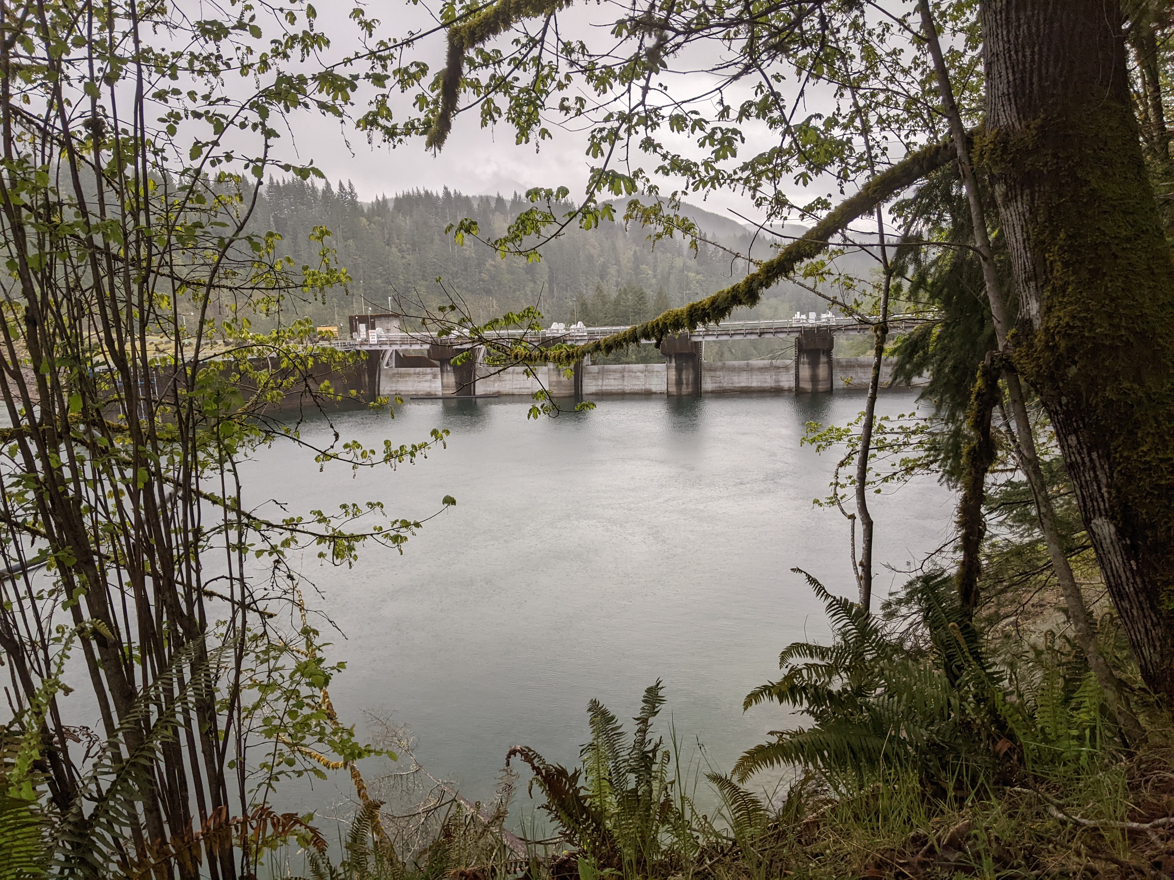
If you love off‑the‑beaten‑path engineering marvels surrounded by pristine forest, the modest yet striking Saddle Dam near Amboy, Washington, should be on your travel radar. Nestled at an altitude of 148 m, this 12‑meter‑high embankment dam quietly supports the Yale Reservoir, offering a perfect blend of industrial history and natural beauty for the curious explorer.
1. Introduction
When most travelers think of Washington State, they picture the iconic Space Needle, the bustling Pike Place Market, or the rugged peaks of the North Cascades. Few anticipate discovering a dam tourism experience just a short drive from the small community of Amboy. Yet there, stretching 488 meters across the valley, the Saddle Dam stands as a testament to early‑20th‑century water‑management engineering. Its unassuming silhouette against the evergreen canopy makes it a photographer’s delight and a quiet spot for contemplation. Whether you’re a civil‑engineering enthusiast, a waterfall hunter, or simply seeking a serene day‑trip away from city crowds, Saddle Dam offers a uniquely rewarding slice of Washington’s water‑way heritage.
2. About Saddle Dam
Description & Technical Details
- Type: Embankment dam (earth‑fill) 🏗️
- Length: 488 m
- Height: 12 m (≈ 39 ft)
- Altitude: 148 m above sea level
- Coordinates: 45.969862 N, –122.340313 W
- Spillway: None (the dam relies on the adjacent Yale Dam for reservoir level control)
Built as a companion structure to the larger Yale Dam, Saddle Dam helps maintain the water level of the Yale Reservoir. While Yale Dam handles the primary flow regulation and spillway functions, Saddle Dam acts as a secondary barrier, reinforcing the reservoir’s western edge. Its earth‑fill construction blends seamlessly with the surrounding forest floor, making it difficult to spot from a distance—yet up close, the careful layering of compacted soil and rock is evident, showcasing the engineering practices of the era.
History & Significance
Although a dedicated Wikipedia entry does not yet exist for Saddle Dam, its origins are closely tied to the development of hydro‑electric power in the Pacific Northwest during the early 1900s. The dam was part of a broader regional effort to harness the Columbia River’s tributaries for reliable electricity generation, supporting growing towns and industries across Washington and Oregon.
In 2020, Pacificorp (the operating utility) released an engineering overview of the dam, confirming its continued structural integrity and its role in the integrated water‑management system that includes Yale Dam. For visitors, this means you’re witnessing a living piece of infrastructure that still performs its original purpose more than a century later.
3. How to Get There
By Car
Saddle Dam is most easily accessed by private vehicle. Here’s a straightforward route for travelers coming from major nearby cities:
| Starting Point | Approx. Driving Time | Suggested Route |
|---|---|---|
| Portland, OR | 2 h 15 m | Take I‑5 north to exit 30 (Amboy). Follow local signage toward Yale Reservoir; the dam sits just off the main access road. |
| Seattle, WA | 2 h 45 m | Travel south on I‑5, then east on WA‑14 toward the Columbia River Gorge. Continue to Amboy and follow the same local directions. |
| The Dalles, OR | 45 m | Head north on I‑84, cross the Columbia River via the Dalles Bridge, then follow US‑197 north to Amboy. |
The final stretch is a well‑maintained, paved forest road (often labeled “Yale Reservoir Road”). Parking is available in a small lot near the dam’s visitor pull‑out, with a short, level walk to the viewing platform.
Public Transportation
Public transit options are limited in this rural part of Washington. The closest Greyhound or Amtrak stations are in The Dalles, Oregon, and Vancouver, WA. From either location, you’ll need to rent a car or arrange a rideshare to reach Amboy.
Air Travel
For out‑of‑state visitors, the most convenient airports are Portland International Airport (PDX) and Seattle‑Tacoma International Airport (SEA). Both airports offer car‑rental services and are within a 2½‑hour drive to Saddle Dam.
4. Best Time to Visit
| Season | Highlights | Weather Considerations |
|---|---|---|
| Spring (Mar–May) | Snowmelt swells the Yale Reservoir, creating vibrant reflections on the dam’s surface. Wildflowers begin to pepper the surrounding meadow. | Temperatures 10‑18 °C (50‑65 °F); occasional rain—bring waterproof shoes. |
| Summer (Jun–Aug) | Long daylight hours (up to 16 h) give ample time for photography, hiking, and picnicking. | Warm, dry days 20‑28 °C (68‑82 °F); perfect for a leisurely stroll. |
| Fall (Sep–Nov) | Brilliant foliage (maple, fir, and cedar) frames the dam, delivering stunning contrast against the water. | Cooler evenings 8‑15 °C (46‑59 °F); occasional fog—good for atmospheric shots. |
| Winter (Dec–Feb) | Snow‑capped trees create a serene, almost magical scene; fewer visitors mean a peaceful experience. | Cold (0‑5 °C / 32‑41 °F); possible icy road conditions—check weather forecasts before traveling. |
Peak visitation tends to be in July and August, so if you prefer a quieter experience, aim for late spring or early fall.
5. What to Expect
Scenic Views
From the modest parking area, a short 200‑meter walk brings you to a sturdy wooden railing that overlooks the Yale Reservoir. The dam’s earthen crest runs parallel to the water, offering a unique perspective: you can see the water level gently lapped against the embankment while the surrounding forest rises in layered shades of green.
Photographic Opportunities
- Golden Hour: The low western sun during sunrise or sunset paints the reservoir in amber tones, highlighting the dam’s texture.
- Reflections: Calm days produce mirror‑like reflections of the surrounding peaks on the reservoir’s surface—ideal for symmetry shots.
- Aerial Views: If you have a drone (and follow Washington State’s UAV regulations), a fly‑over captures the dam’s full 488‑meter length in context with the surrounding terrain.
Wildlife & Flora
The area is part of the Columbia River Gorge ecosystem, home to black‑tailed deer, great‑horned owls, and occasional salmon runs in the tributaries. The forest floor is dotted with ferns, western trillium, and vibrant mosses, especially after rain.
Facilities
- Restrooms: Portable toilets are available near the parking lot (seasonally serviced).
- Picnic Tables: A few benches and tables sit beside the viewing platform, perfect for a snack with a view.
- Interpretive Signage: A brief plaque explains the dam’s purpose and its relationship to Yale Dam, offering context for curious minds.
6. Nearby Attractions
After exploring Saddle Dam, extend your adventure with these must‑see spots, all within a 7‑kilometer radius:
| Attraction | Distance | Type | Why Visit? |
|---|---|---|---|
| Yale Dam | 0.7 km | Dam | The primary water‑control structure for the reservoir; impressive concrete arch design. |
| Canyon Creek Falls | 2.3 km | Waterfall | A 30‑meter cascade hidden in a lush canyon—great for a short hike and a splash of mist. |
| Champagne Falls | 2.7 km | Waterfall | Named for its frothy, sparkling water; accessible via a gentle forest trail. |
| Chelatchie Prairie Mill Pond Dam | 4.9 km | Dam | Historic mill‑pond site offering a glimpse into early logging operations. |
| Fly Creek Falls | 6.6 km | Waterfall | A series of tiered falls that culminate in a natural swimming hole—ideal for a summer dip. |
Each destination is reachable via well‑marked forest roads or short hiking trails. Pack a day‑pack, water, and a camera to capture the diversity of scenery—from engineered structures to cascading waterfalls.
7. Travel Tips
- Check Road Conditions – The forest road to Yale Reservoir can be slick after rain or snow. The Washington State Department of Transportation (WSDOT) provides real‑time updates.
- Leave No Trace – The area is a protected watershed. Pack out all trash, stay on designated paths, and avoid disturbing wildlife.
- Timing for Waterfalls – Spring runoff yields the most vigorous flow at Canyon Creek and Champagne Falls. If you’re chasing waterfalls, plan your visit between March and May.
- Safety First – No spillway exists on Saddle Dam, so the water level can rise quickly during heavy rain. Keep a safe distance from the reservoir’s edge, especially after storms.
- Cell Service – Coverage is spotty. Download offline maps (Google Maps or AllTrails) before you head out.
- Bring Layers – Even in summer, mornings can be cool at 148 m elevation, and evenings dip quickly. A light fleece or windbreaker is advisable.
- Photography Gear – A wide‑angle lens captures the dam’s length; a polarizing filter reduces glare on the water. If you’re using a drone, remember to stay at least 5 km from the nearest airport and respect the 400‑ft altitude limit.
Wrap‑Up
Saddle Dam may not boast the grandeur of the Hoover or Grand Coulee, but its quiet presence amid Washington’s verdant wilderness offers a rewarding blend of engineering history, scenic beauty, and outdoor adventure. Whether you’re ticking off a “dam tourism” bucket list, chasing waterfalls, or simply craving a peaceful spot to unwind, this hidden gem near Amboy is worth the short drive.
Pack your camera, lace up your boots, and let the gentle hum of the reservoir guide you to an unforgettable Washington experience. Safe travels!