Max Starcke Dam – A Hidden Texas Gem in Marble Falls
If you’ve ever dreamed of a tranquil lakeside escape framed by rolling Hill Country hills, the Max Starcke Dam is the perfect spot to add to your Texas road‑trip itinerary. Nestled just a few miles north of the charming town of Marble Falls, this historic dam offers sweeping water‑front vistas, quiet fishing spots, and a gateway to a cluster of quirky attractions that showcase the spirit of Central Texas. Whether you’re a nature lover, a history buff, or simply looking for a scenic photo‑op, Max Starcke Dam should be high on your “must‑see” list.
About Max Starcke Dam
Location: Marble Falls, Texas, United States
Coordinates: 30.556607, ‑98.256588
Type: Dam (🏗️)
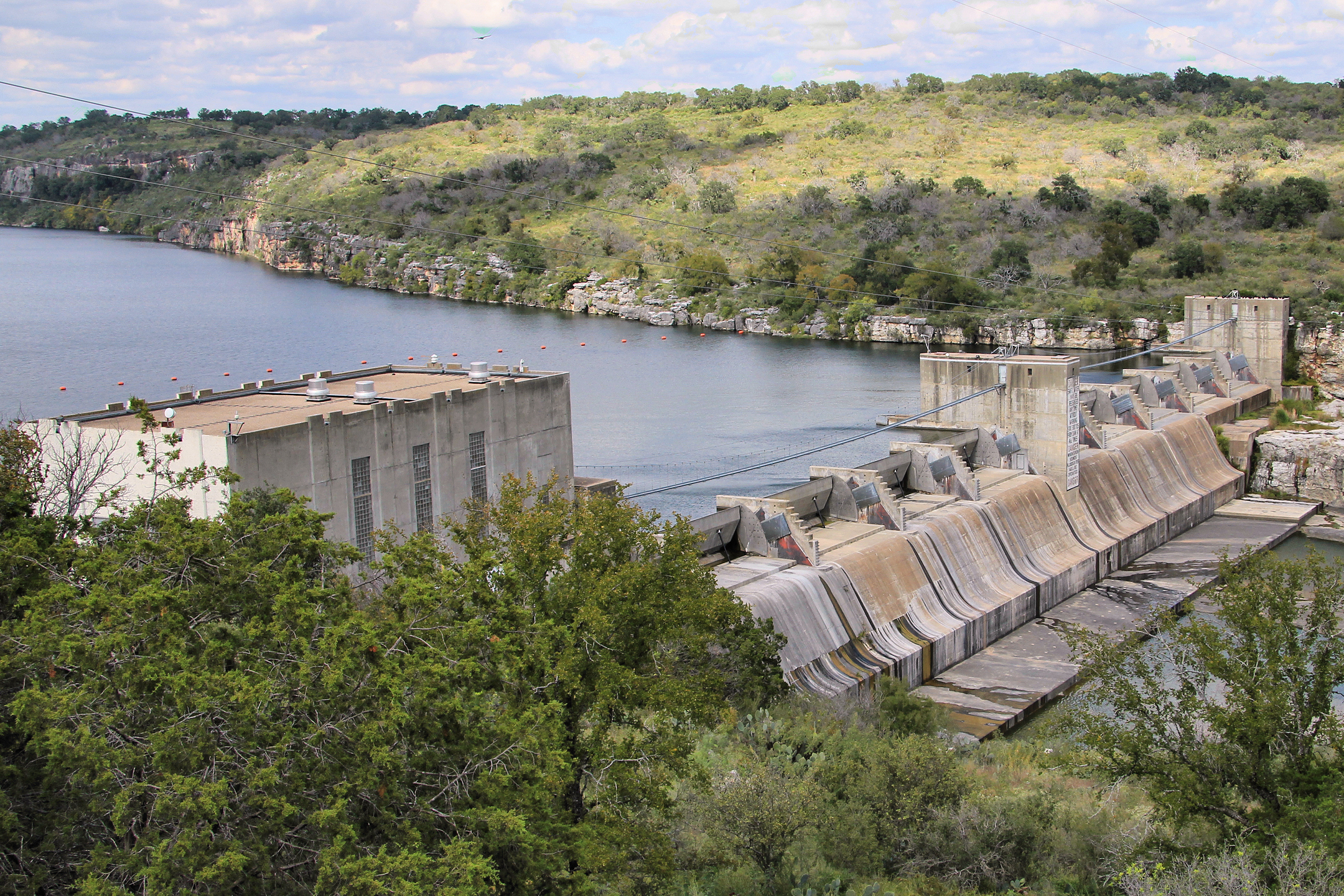
Built in the early‑20th century, Max Starcke Dam was named after Max Starcke, a former mayor of the nearby town of Seguin and a Texas public‑service champion. While the exact height and altitude of the structure remain undocumented in public records, the dam’s presence is unmistakable—its concrete spillway cuts across the Colorado River, forming the serene waters of Lake Marble Falls downstream.
The dam’s primary purpose is to regulate water flow for flood control, irrigation, and recreation. Over the decades, it has become a beloved local landmark, offering anglers a chance to reel in largemouth bass, catfish, and sunfish, while hikers and cyclists enjoy the surrounding Hill Country trails. Its proximity to the historic Original Marble Falls Fountain (just 2.3 km away) ties the dam to the town’s early settlement story, where settlers first harnessed the river’s power for milling and irrigation.
For a quick reference, check out the official Wikipedia entry: Max Starcke Dam.
How to Get There
By Car
The most convenient way to reach Max Starcke Dam is by driving. From Austin, hop onto TX‑71 West (the Hill Country Expressway) and follow the signs for Marble Falls. After about 45 minutes, you’ll arrive at the town’s main thoroughfare—U.S. Highway 281—which runs parallel to the Colorado River. Turn left onto Lake Marble Falls Road; the dam’s parking area is clearly marked just a short distance down the road.
If you’re coming from San Antonio, take I‑35 North to US‑281 and then follow the same route eastward. The total drive is roughly 2 hours, making it an easy day‑trip from either city.
Public Transportation
While there is limited public transit in the Hill Country, the Capital Area Rural Transportation System (CARTS) offers a weekday bus service from Austin to Marble Falls. From the Marble Falls bus stop, a short taxi or rideshare ride (≈ 5 minutes) will drop you off at the dam’s visitor parking lot.
Parking & Accessibility
A modest, free parking lot sits beside the dam, providing space for cars, RVs, and a few handicap‑accessible spots. The walkways around the spillway are paved and level, making the site comfortable for families with strollers or visitors with mobility concerns.
Best Time to Visit
| Season | Weather | Why Visit |
|---|---|---|
| Spring (Mar – May) | Mild temperatures (65‑80 °F) and blooming wildflowers | Perfect for photography, bird‑watching, and picnics |
| Summer (Jun – Aug) | Warm (80‑95 °F) with occasional thunderstorms | Ideal for water‑based recreation—kayaking, fishing, or a cool dip |
| Fall (Sep – Nov) | Pleasant (60‑75 °F) and crisp evenings | Scenic foliage, lower crowds, and excellent fishing |
| Winter (Dec – Feb) | Cool (40‑55 °F) with occasional frosts | Quiet atmosphere; great for sunrise walks and stargazing |
Overall, late spring and early fall offer the most comfortable climate for outdoor activities, while summer draws water‑sport enthusiasts. Winter visitors should dress in layers, as temperatures can dip sharply after sunset.
What to Expect
Arriving at Max Starcke Dam, you’ll first notice the gentle roar of water spilling over the concrete crest—a soothing soundtrack that instantly relaxes. The surrounding landscape is a classic Hill Country tableau: limestone outcrops, towering oak and cedar trees, and the glistening surface of Lake Marble Falls stretching into the distance.
Activities
- Fishing: Cast a line from the designated fishing pier or from the shore. The Colorado River here is stocked with largemouth bass, catfish, and crappie.
- Kayaking & Canoeing: Small launch points near the dam let you paddle upstream or downstream, offering close‑up views of the spillway and the river’s meanders.
- Picnicking: Picnic tables and shaded benches line the riverbank, perfect for a family lunch or a solo snack while watching the water flow.
- Photography: Sunrise and sunset paint the water in gold and pink hues, while the dam’s geometric lines provide striking foregrounds for landscape shots.
- Birdwatching: Keep an eye out for white‑tailed deer, great‑horned owls, and a variety of waterfowl that frequent the area.
Amenities
- Restrooms: Portable toilets are available near the parking lot.
- Information Kiosk: A small interpretive board explains the dam’s history and the local ecosystem.
- Wi‑Fi: Free, limited‑range Wi‑Fi is offered by the Marble Falls tourism office, ideal for uploading those fresh photos.
Nearby Attractions
After soaking in the serenity of Max Starcke Dam, venture a few minutes away to discover more Hill Country highlights. All distances are as‑the‑crow‑fly from the dam.
-
The Original Marble Falls Fountain – 2.3 km
The historic fountain that gave the town its name. Stroll around the plaza and learn about Marble Falls’ early settlement.
Learn more → -
(Weir) – 2.5 km
A modest weir that showcases traditional water‑management techniques used by early ranchers. Great spot for a quiet pause. -
Dead Man’s Hole Historical Landmark (Waterfall) – 3.2 km
A dramatic limestone cascade with a spooky legend—perfect for a short hike and a splash of local folklore.
Visit the landmark → -
Meadowlakes Number 1 Dam – 3.9 km
Another small dam that creates a serene pond ideal for birdwatching and gentle fishing. -
Lake Marble Falls (Waterfall) – 4.0 km
A scenic waterfall that feeds into the lake, offering a picturesque backdrop for photos and a peaceful listening spot.
These attractions are easily reachable by car or bike, allowing you to craft a full‑day itinerary that blends nature, history, and local culture.
Travel Tips
| Tip | Details |
|---|---|
| Bring Water & Snacks | While there are picnic tables, there are no on‑site food vendors. Pack a cooler with drinks and snacks. |
| Sun Protection | The Hill Country sun can be intense, especially in summer. Sunscreen, hats, and sunglasses are a must. |
| Fishing License | Texas requires a valid fishing license for anglers. Purchase one online or at local retailers before you head out. |
| Leave No Trace | Keep the area pristine—use designated trash bins and avoid disturbing wildlife. |
| Check Water Levels | Seasonal water levels can affect boat launch access. The Marble Falls visitor center posts current conditions on its website. |
| Timing for Photography | For the best light, aim for the “golden hour”—30 minutes after sunrise or before sunset. |
| Safety First | The spillway can be slippery. Keep a safe distance from the water’s edge, especially after rain when currents are stronger. |
| Local Events | Marble Falls hosts seasonal festivals (e.g., Marble Falls Music Festival in spring). Check the town’s calendar to combine your dam visit with a local celebration. |
Final Thoughts
Max Starcke Dam may not have the fame of Texas’s larger reservoirs, but its quiet charm, easy accessibility, and proximity to a cluster of off‑the‑beaten‑path attractions make it a standout destination for any traveler exploring Central Texas. Whether you’re casting a line at sunrise, snapping panoramic shots of the Hill Country, or simply unwinding by the water’s edge, the dam offers a slice of Texas tranquility that’s hard to find elsewhere.
So load up the car, grab your camera, and set your GPS to 30.556607, ‑98.256588—the heart of Marble Falls awaits. Safe travels, and enjoy the gentle roar of Max Starcke Dam!