Discover the Quiet Charm of Dam No. 4 – A Hidden Weir in Brackenridge, Pennsylvania
If you’re chasing off‑the‑beaten‑path waterway wonders, the modest yet captivating Dam No. 4 should be on your radar. Nestled in the rolling hills of Brackenridge, Pennsylvania, this 5‑meter‑high weir offers a perfect blend of engineering history, serene scenery, and easy access for day‑trippers and avid photographers alike.
1. Introduction
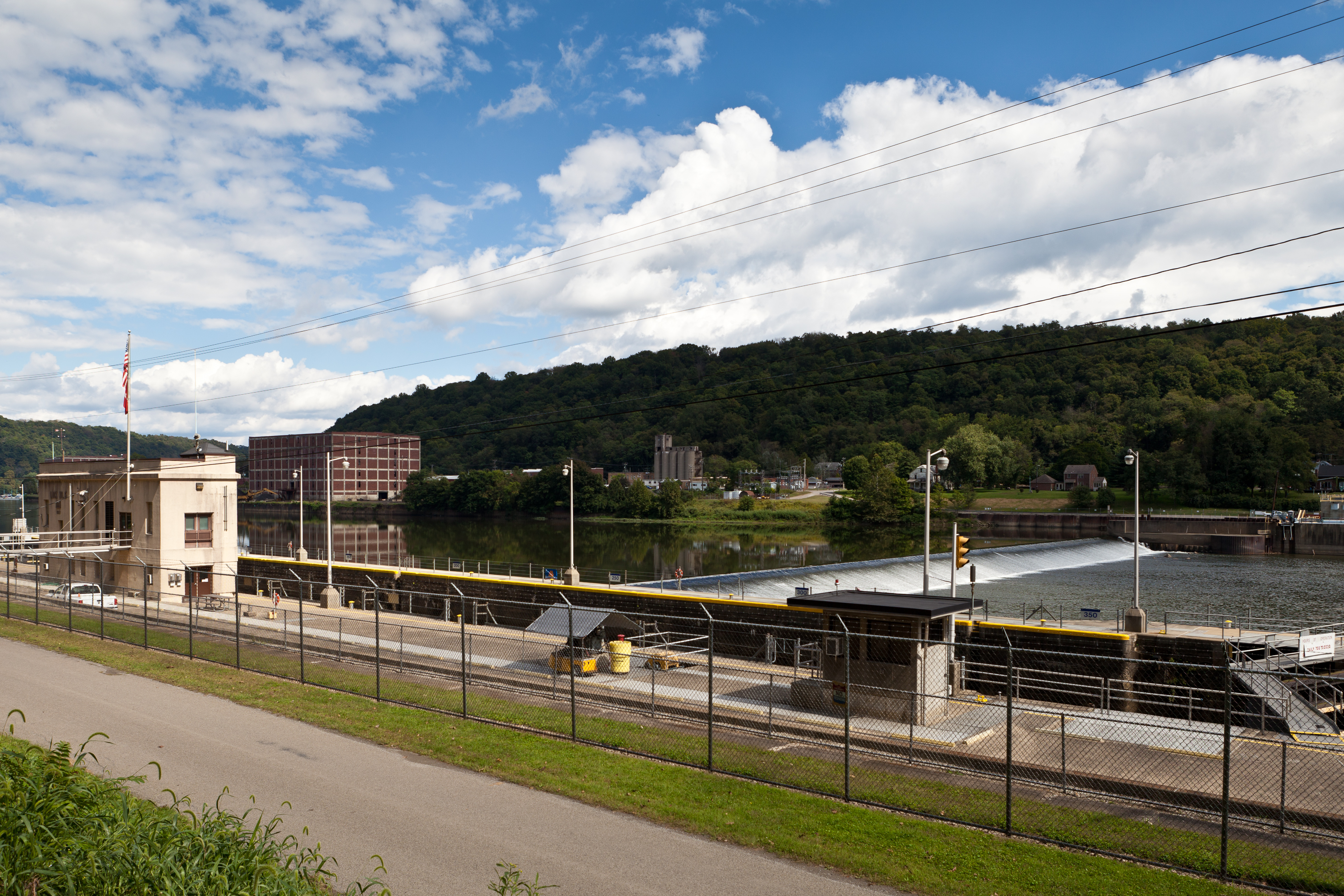
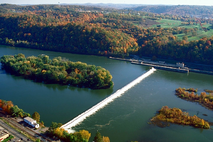
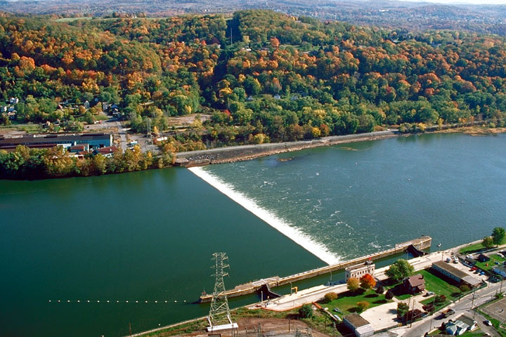
Imagine standing on a concrete crest that stretches nearly 270 meters (876 feet) across a river, watching water glide over its uniform lip as if the river itself were a glossy ribbon. That’s the everyday magic of Dam No. 4, a low‑profile weir on the Allegheny River that quietly regulates flow while providing a striking backdrop for outdoor enthusiasts. Unlike the towering dams that dominate headlines, Dam No. 4 invites you to pause, breathe, and appreciate the subtle beauty of Pennsylvania’s inland waterways.
Whether you’re a history buff, a nature lover, or simply looking for a peaceful spot to snap a sunrise, this unassuming structure delivers an authentic slice of the Keystone State’s river heritage—without the crowds.
2. About Dam No. 4
A Brief Description
- Type: Weir (also referred to as a low‑head dam)
- Location: Brackenridge, Pennsylvania, United States
- Coordinates: 40.613380 N, ‑79.717245 W
- Height: 5.0 m (≈ 16 ft) – roughly 38 feet when measured from the riverbed to the crest
- Length: 876 ft (≈ 267 m)
- Altitude: 227 m above sea level
- Structure: Concrete slab keyed into bedrock, with a 1:1 slope and a short downstream apron. The crest is level, allowing water to spill uniformly across its entire length.
For a deeper dive into its engineering and historical context, check out the official Wikipedia entry: Allegheny River Lock and Dam No. 4.
Historical Significance
Dam No. 4 is part of a series of lock‑and‑dam structures built along the Allegheny River during the early 20th century to improve navigation, generate modest hydro‑power, and control flooding. While larger dams in the system handle commercial traffic, Dam No. 4 primarily serves local recreation and ecological balance. Its concrete construction, keyed directly into the underlying bedrock, reflects the robust engineering practices of its era—designed to last for generations with minimal maintenance.
Why It Matters
- Ecological Role: The weir creates a subtle pool upstream, supporting fish habitats and offering a calm stretch for kayakers.
- Recreational Hub: Anglers, birdwatchers, and photographers love the steady flow and reflective surface.
- Cultural Landmark: As one of the few remaining low‑head dams in western Pennsylvania, it stands as a tangible reminder of the region’s river‑based industrial past.
3. How to Get There
By Car
- Start from Pittsburgh – From downtown Pittsburgh, take I‑376 E (the “Parkway East”) toward Monroeville.
- Merge onto US‑22 E – Follow signs for “Johnstown/Altoona” and stay on US‑22 for roughly 30 miles.
- Take Exit 71 (PA‑48 S) – This leads you toward the town of Brackenridge.
- Follow PA‑48 S to PA‑910 – Turn left onto PA‑910 W (also known as “West Deer Road”).
- Arrive at Dam No. 4 – After about 2 miles, look for a small pull‑out or parking area near the riverbank. Use the GPS coordinates 40.613380, ‑79.717245 for precise navigation.
Tip: The road is well‑maintained, but the final stretch to the river can be narrow. A compact vehicle or SUV is ideal.
By Public Transit
While there is no direct train or bus service to the dam, you can take the Port Authority’s Route 28 to the Brackenridge stop, then hail a rideshare or local taxi for the remaining 5‑minute drive.
By Bike or Foot
For the adventurous, the Allegheny River Trail (a network of multi‑use paths) runs within a few miles of the weir. Cyclists can park at the trailhead near the Brackenridge Community Center and walk the last half‑mile to the water’s edge.
4. Best Time to Visit
| Season | Highlights | Weather Considerations |
|---|---|---|
| Spring (Mar‑May) | Freshwater runoff raises river levels, making the spill over the weir spectacular. Wildflowers bloom along the banks. | Expect occasional rain; bring waterproof shoes. |
| Summer (Jun‑Aug) | Warm, calm days are perfect for picnics and sunrise photography. | Peak visitor numbers; arrive early for a quiet spot. |
| Fall (Sep‑Nov) | Brilliant foliage reflects off the water, creating vibrant color contrasts. | Cooler evenings; pack a light jacket. |
| Winter (Dec‑Feb) | Ice formations on the downstream apron give a dramatic, moody backdrop. | Sub‑freezing temps; check road conditions before traveling. |
Overall recommendation: Late April to early October offers the most comfortable climate and the best lighting for photography.
5. What to Expect
Visual Experience
Approaching Dam No. 4, you’ll first notice the uniform concrete crest—a sleek, straight line that seems to slice the river in half. As the water reaches the weir, it cascades over the entire width, creating a steady, white‑foamed ribbon. The sound is a gentle roar, perfect for meditative listening or background ambience for a vlog.
Activities
- Photography: Capture long‑exposure shots of the water’s silky flow or frame the dam against sunrise hues.
- Kayaking & Canoeing: The upstream pool offers calm water for paddlers; downstream, the current picks up, providing a mild challenge for intermediate kayakers.
- Fishing: The pool attracts smallmouth bass, catfish, and panfish—ideal for a relaxed angling session.
- Birdwatching: Look up to spot ospreys, great‑horned owls, and migratory waterfowl that frequent the river corridor.
Amenities
The site is unstaffed and free to access. There is a modest parking pull‑out with a few benches and a trash receptacle. Restrooms are not available on‑site, so plan accordingly.
6. Nearby Attractions
While Dam No. 4 is the star of the show, the surrounding area offers several complementary spots worth exploring—each within a 10‑kilometer radius:
- Upper West Deer Lake Dam – 8.8 km away. A larger reservoir ideal for boating and picnicking.
- Dam No. 5 – 8.9 km away. Another historic weir with a slightly higher crest, perfect for comparative photography.
- Middle West Deer Dam – 9.1 km away. A quiet fishing spot surrounded by mature hardwoods.
- Lower West Deer Lake Dam – 9.5 km away. Features a scenic walking trail along the lake’s edge.
- Local Fountain (Unnamed) – 9.6 km away. A charming public fountain in the nearby town center, great for a quick coffee break.
Combine these sites into a full‑day itinerary or a relaxed weekend getaway—each destination adds a unique flavor to your Pennsylvania river adventure.
7. Travel Tips
- Bring a GPS Device: The exact coordinates (40.613380, ‑79.717245) will guide you straight to the weir, especially useful if cellular service is spotty.
- Pack Light Snacks & Water: No food vendors operate on‑site. A portable cooler or snack bag will keep you energized.
- Dress in Layers: River breezes can be cooler than inland temperatures, especially in early morning or late evening.
- Respect the Environment: The weir is a functional piece of infrastructure; avoid climbing on the crest or littering.
- Safety First: The water downstream can be swift. Keep a safe distance from the spillway edge, especially if you’re traveling with children.
- Timing for Photography: The “golden hour” (30 minutes after sunrise or before sunset) casts a warm glow on the concrete and enhances water reflections.
- Check Road Conditions: Winter snow or spring flooding can affect access roads. Local PennDOT updates are available online.
Wrap‑Up
Dam No. 4 may not boast the dramatic height of famous hydro‑electric dams, but its understated elegance, historic roots, and tranquil surroundings make it a must‑visit hidden gem for anyone exploring western Pennsylvania. From sunrise silhouettes to quiet afternoons of fishing, this weir invites you to slow down, soak in the river’s rhythm, and discover a slice of American engineering that still serves the land and its people today.
Pack your camera, chart your route, and let the gentle roar of Dam No. 4 guide you into a uniquely peaceful Pennsylvania adventure. Safe travels!