Dam No. 3 – The Hidden Weir Gem of Cheswick, Pennsylvania
Discover the quiet power of the Allegheny River and the historic engineering that still shapes western Pennsylvania.
Introduction
If you think Pennsylvania’s attractions are limited to rolling hills, historic towns, and cheesesteaks, think again. Tucked just 20 miles east of downtown Pittsburgh, the Allegheny River Lock and Dam No. 3—commonly called Dam No. 3—offers a surprisingly serene spot for river‑lover travelers, photographers, and anyone looking for a slice of industrial heritage set against a natural backdrop. This 30‑foot‑high, 1,434‑foot‑long weir is more than a functional piece of infrastructure; it’s a living reminder of the early‑20th‑century river navigation system that helped turn western Pennsylvania into an industrial powerhouse. In this guide, we’ll walk you through everything you need to know to make the most of a visit to this understated yet captivating destination.
About Dam No. 3
A Brief History
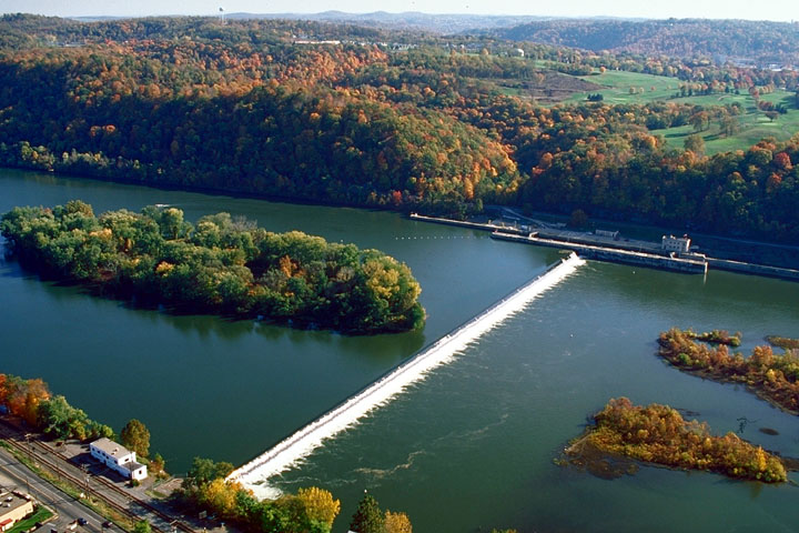
Built as part of the Allegheny River navigation project, Dam No. 3 was completed in the early 1900s to tame the river’s natural rapids and create a reliable channel for commercial barges. The structure is a fixed‑crest weir, meaning its top runs at a uniform height across the entire length, allowing water to spill over the crest uniformly. While the locks that enable vessels to move upstream and downstream rest solidly on bedrock, the dam itself sits on a series of timber piles—a construction technique that was common before the advent of modern concrete foundations.
The dam’s approximately 30‑foot height and 1,434‑foot length may not sound monumental, but its presence has been vital for flood control, water‑level regulation, and navigation on the Allegheny River for more than a century. Today, the structure is still operational, and the gentle roar of water spilling over its crest is a constant soundtrack for visitors.
Why It Matters
- Historical significance – Dam No. 3 is part of a chain of 12 locks and dams that transformed the Allegheny River into a navigable waterway, supporting steel, coal, and manufacturing industries that defined Pennsylvania’s economy.
- Ecological role – By regulating water flow, the dam creates habitats for fish, waterfowl, and other wildlife that thrive in the river’s backwaters.
- Scenic value – The uniform spill creates a steady, mesmerizing cascade that is perfect for photography, especially at sunrise or sunset when the water catches the light.
How to Get There
By Car
| Starting Point | Approx. Distance | Suggested Route |
|---|---|---|
| Pittsburgh, PA (downtown) | 20 mi (≈ 32 km) | Take I‑376 East toward Monroeville, merge onto I‑76 (Pennsylvania Turnpike) East, exit at PA‑28 North toward Kittanning, then follow signs for Cheswick. |
| Harrisburg, PA | 140 mi (≈ 225 km) | Head west on I‑76 (Turnpike) to I‑376, then follow the same route as above. |
| Philadelphia, PA | 300 mi (≈ 480 km) | Take I‑76 West (Pennsylvania Turnpike) to I‑376, then continue north on PA‑28. |
There is a small public parking area on the north side of the river, just off River Road (PA‑910). The lot fills up quickly on weekends during summer, so aim to arrive early (7 – 8 am) for a guaranteed spot.
Public Transportation
While there is no direct train or bus service to the dam itself, Port Authority’s 28X bus runs from downtown Pittsburgh to the Monroeville Transit Center. From there, a short ride‑share or taxi (≈ 15 min) will drop you at the River Road turn‑off. For the most flexibility, renting a car for the day is recommended.
Walking & Biking
The Allegheny River Trail—a multi‑use path that follows the river for over 30 miles—passes within a few hundred feet of the dam. If you’re staying in Cheswick or nearby suburbs, you can bike or walk the trail to reach the viewing platform. The path is paved and wheelchair‑accessible.
Best Time to Visit
| Season | Highlights | Tips |
|---|---|---|
| Spring (Mar‑May) | River levels rise with snowmelt, creating a fuller cascade and vibrant foliage along the banks. | Bring a rain jacket; the area can be misty. |
| Summer (Jun‑Aug) | Warm weather makes the surrounding park ideal for picnics and bird‑watching. Early mornings are quieter. | Arrive before 10 am to avoid crowds; sunscreen and water are essential. |
| Fall (Sep‑Nov) | Autumn colors reflect off the water, offering spectacular photo opportunities. | Check the USGS river gauge for optimal water flow; lower levels may expose more of the dam’s timber piles. |
| Winter (Dec‑Feb) | Ice formations on the spillway create a dramatic, almost otherworldly scene. | Dress in layers; paths may be icy—use sturdy boots with traction. |
Overall, late spring through early fall provides the most comfortable conditions for exploring the site, while winter offers a unique, quieter experience for those prepared for colder weather.
What to Expect
Visual & Auditory Experience
As you approach the dam, the first thing you’ll notice is the steady, white‑capped water spilling over the uniform crest. The sound is a soothing, constant rush—perfect for meditative walks or background ambiance while you sip a coffee from a nearby café. The timber‑pile foundations are partially visible during low water, offering a glimpse into the engineering methods of a bygone era.
Wildlife
The Allegheny River corridor is a hotspot for eastern kingfishers, great blue herons, and bald eagles. Bring binoculars for close‑up viewing, especially during migration periods in spring and fall. The shallow backwaters downstream of the dam provide spawning grounds for smallmouth bass and catfish, making the area popular with local anglers (though fishing is restricted directly at the dam for safety).
Photography
- Golden hour (first hour after sunrise or last hour before sunset) casts a warm glow on the water’s surface.
- Long‑exposure shots of the spillway create silky water effects—use a tripod and ND filter.
- Aerial perspectives can be captured via drone (check local FAA regulations; the dam is within a Class G airspace, but stay at least 500 ft above the structure).
Facilities
- Restrooms: Portable toilets are available near the parking lot (seasonally serviced).
- Picnic tables: A few benches line the riverbank, ideal for a quick lunch.
- Interpretive signage: Small plaques explain the dam’s function and history—great for families and school groups.
Nearby Attractions
While Dam No. 3 can easily fill a half‑day itinerary, the surrounding area offers several other water‑related sites worth a quick detour. All distances are as‑the‑crow‑flies from the dam.
| Attraction | Distance | What to See | Link |
|---|---|---|---|
| Cheswick Emergency Ash Pond | 2.2 km | A quiet reservoir used for emergency water storage; perfect for a short walk. | Cheswick Emergency Ash Pond |
| Harmar Storage Pond No 4 | 2.7 km | Small fishing spot with a rustic dock. | Harmar Storage Pond No 4 |
| Harmon Refuse Bank Dam | 2.7 km | Industrial‑heritage dam with interpretive panels on waste‑water management. | Harmon Refuse Bank Dam |
| Campbells Pond Dam | 6.4 km | A larger reservoir surrounded by hiking trails and bird‑watching platforms. | Campbells Pond Dam |
| Allegheny River Lock & Dam No. 2 | 6.0 km | The next lock downstream; offers a similar view and historic lockhouse tours (seasonal). | Allegheny River Lock and Dam No. 2 |
These sites are all reachable within a 15‑minute drive, making them perfect for a “River‑Side Loop” that showcases the engineering legacy of the Allegheny.
Travel Tips
- Check Water Levels – The U.S. Geological Survey provides real‑time river gauge data for the Allegheny. Higher water means a more dramatic spill; lower water reveals the timber piles and makes the backwater area ideal for wading (if permitted).
- Parking – The lot fills quickly on sunny weekends. Arrive early or consider the river trail for a car‑free approach.
- Safety First – The water can be swift, especially after rain. Stay behind the railings, keep children supervised, and never attempt to climb the dam.
- Bring Essentials – Comfortable walking shoes, a wind‑breaker, reusable water bottle, and a good camera or smartphone with a macro lens for close‑up nature shots.
- Respect the Site – This is an operational water‑control structure. Littering, swimming, or fishing directly at the dam is prohibited. Use designated trash receptacles.
- Local Eats – After your visit, stop at The River’s Edge Café in nearby West Homestead for a riverside lunch featuring locally sourced Pennsylvania Dutch dishes.
- Seasonal Events – The Allegheny River Heritage Festival takes place each October in nearby Kittanning; it includes guided tours of the lock and dam system—check the schedule if your trip coincides.
Wrap‑Up
Dam No. 3 may not have the towering fame of the Grand Canyon or the glitz of a city skyline, but its quiet, steady presence on the Allegheny River offers a unique blend of industrial history, natural beauty, and recreational opportunity. Whether you’re a history buff, a photographer chasing that perfect water‑over‑rock shot, or simply a traveler looking for an off‑the‑beaten‑path spot in western Pennsylvania, this weir deserves a place on your itinerary. Pack a snack, bring your curiosity, and let the gentle roar of Dam No. 3 guide you into the heart of the Keystone State’s river heritage.
Happy travels!