Proxy Falls – Oregon’s Hidden Waterfall Gem
If you’ve ever dreamed of chasing a curtain of water that feels like a secret whispered only to those willing to hike a few miles into the forest, Proxy Falls in Central Oregon is that hidden treasure. Nestled in the rugged beauty of the Deschutes National Forest near the charming town of Sisters, this 68‑meter (225‑foot) plunge drops into a moss‑laden pool that looks straight out of a postcard. Whether you’re a seasoned waterfall hunter, a family looking for a day‑trip adventure, or a photographer hunting that perfect long‑exposure shot, Proxy Falls should be at the top of your Oregon itinerary.
About Proxy Falls
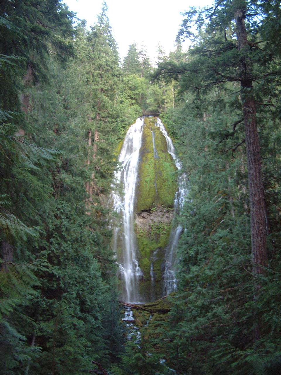
Proxy Falls is a classic plunge‑type waterfall—the water free‑falls straight down without touching the rock face, creating a dramatic, sheer drop that’s especially striking when the sun catches the mist. At 68.9 m (≈225 ft), it ranks among the taller waterfalls in the state, yet it remains relatively unknown compared to the famous Multnomah Falls or Silver Falls.
The falls sit at the coordinates 44.162006, ‑121.927764 and are fed by a series of high‑elevation springs that cascade down the volcanic basalt cliffs of the Cascade Range. While the exact altitude of the falls isn’t listed in official sources, the surrounding forest sits at roughly 1,300–1,500 ft above sea level, giving the area a cool, alpine feel even in summer.
Historically, the name “Proxy” is believed to have originated from early forest rangers who used the falls as a proxy reference point when mapping the dense timberland. Today, the waterfall is a beloved waypoint for hikers, anglers, and anyone looking to experience the raw power of Oregon’s watercourses.
For a quick factual snapshot, see the Proxy Falls Wikipedia page.
How to Get There
From Sisters, Oregon
- Start in Sisters – This artsy, Western‑styled town is the gateway to many Central Oregon adventures.
- Head East on US‑20 – Follow the highway for about 10 mi (the exact mileage can vary depending on your starting point).
- Turn onto Forest Service Road 33 – Look for signage that reads “Proxy Falls Trailhead.” The road is paved for the first mile, then transitions to a well‑graded gravel surface.
- Use GPS – Plug the coordinates 44.162006, ‑121.927764 into your navigation device for the most direct route to the parking area.
The Proxy Falls Trailhead is just 0.7 km (≈0.4 mi) from the waterfall itself, making the hike short enough for families but long enough to feel like a true back‑country escape. Parking is free, but spaces can fill quickly during peak summer weekends, so arrive early or consider a weekday visit.
What to Bring
- Sturdy hiking shoes – The trail can be slick from spray.
- Waterproof jacket – Even on sunny days, the mist creates a cool micro‑climate.
- Camera/phone with waterproof case – For those iconic waterfall shots.
- Snacks and plenty of water – There are no services on the trail.
Best Time to Visit
| Season | Conditions | Why Visit |
|---|---|---|
| Spring (Mar–May) | Snowmelt swells the flow; the surrounding forest is a burst of green. | Highest water volume, vivid foliage. |
| Summer (Jun–Aug) | Warm days, moderate flow, longer daylight. | Ideal for photography and family hikes. |
| Fall (Sep–Oct) | Leaves turn amber; crowds thin out. | Photogenic colors, quieter trails. |
| Winter (Nov–Feb) | Possible snow and ice on the trail; water may be reduced. | For adventurous hikers comfortable with icy conditions. |
Peak visitation tends to be late June through early August, when the trail is fully open and the water is robust but not yet at its spring melt peak. If you prefer a more tranquil experience, aim for early September when the crowds have thinned but the falls still roar impressively.
What to Expect
As you step onto the Proxy Falls Trail, a short, well‑maintained path winds through a mixed conifer forest of Douglas fir, western larch, and ponderosa pine. The air is scented with pine resin and the faint, fresh aroma of the waterfall’s mist.
After roughly 0.7 km of gentle ascent, the canopy parts, revealing the waterfall’s full glory. Water plunges from a sheer basalt cliff into a crystal‑clear pool, surrounded by moss‑covered rocks that look like a natural amphitheater. On sunny days, rainbows often arc across the spray—perfect for that Instagram moment.
The pool at the base is swimmable, though the water stays cold year‑round. Many visitors dip a foot in to feel the refreshing chill, but be mindful of slippery rocks. The surrounding area offers several viewpoints: a lower platform for close‑up shots of the cascade, and a higher ridge that frames the falls against the distant Cascade peaks.
If you’re a birdwatcher, keep an eye out for Steller’s jays, Northern flickers, and occasional golden eagles soaring overhead. The forest floor is dotted with wildflowers in late spring—painted trillium, lupine, and Oregon’s signature camas.
Nearby Attractions
While Proxy Falls can easily fill a half‑day, the surrounding Deschutes National Forest offers several complementary stops that make for a perfect waterfall‑hopping itinerary.
- Upper Proxy Falls – Just 0.3 km upstream, this smaller cascade provides a quieter spot for picnicking and offers a different angle of the same water system.
- Nearby Springs – Two natural springs lie 0.4 km from the falls. Though unnamed in most guides, they create tiny bubbling pools that are perfect for a quick splash or a calming pause.
- Proxy Falls Trailhead – The starting point for the hike, equipped with a small parking lot, interpretive signs, and a restroom.
- Linton Falls – Approximately 3.5 km away, this multi‑tiered waterfall is a short drive further into the forest and offers a more rugged, off‑the‑beaten‑path experience.
These spots can be linked together into a waterfall loop that takes most of the day, allowing you to sample different water flows, forest habitats, and photo opportunities without backtracking to Sisters.
Travel Tips
- Arrive Early – Parking fills up quickly during summer weekends. Getting there by 8 a.m. guarantees a spot and cooler temperatures for hiking.
- Check Road Conditions – Forest Service Road 33 can be closed after heavy rain or snow. The U.S. Forest Service website posts real‑time updates.
- Leave No Trace – Pack out all trash, stay on marked trails, and avoid disturbing the delicate moss that clings to the rocks.
- Safety First – The spray zone near the base is slippery. Wear shoes with good traction and keep children close.
- Photography Hacks – Use a neutral density (ND) filter for silky‑smooth water effects, and shoot during the “golden hour” (just after sunrise or before sunset) for warm lighting.
- Wildlife Awareness – Keep food sealed and stored away from the campsite or picnic area to avoid attracting bears or raccoons.
- Seasonal Gear – In early spring, bring microspikes or sturdy crampons if the trail is still icy from meltwater.
Wrap‑Up
Proxy Falls may not have the fame of Oregon’s larger waterfalls, but its intimate scale, dramatic drop, and pristine forest setting make it a standout destination for anyone traveling through Central Oregon. The short hike from the trailhead, the reliable water flow, and the surrounding network of springs and nearby falls give you a full day of adventure without the crowds.
So load up your camera, lace your hiking boots, and head east from Sisters to discover why this hidden cascade is quickly becoming a favorite among Oregon’s outdoor enthusiasts.
Happy trails, and may your next waterfall selfie be as crystal‑clear as the pool at the base of Proxy Falls!

