Hungry Horse Dam – Montana’s Majestic Engineering Marvel
If you’re looking for a blend of rugged wilderness, awe‑inspiring engineering, and endless outdoor adventure, Hungry Horse Dam in Columbia Falls, Montana should be at the top of your itinerary. Nestled against the towering peaks of the Rocky Mountains, this 172‑meter‑tall concrete arch dam not only powers the region but also offers a spectacular backdrop for photography, fishing, and hiking. Read on for everything you need to know to make the most of your visit to Hungry Horse Dam.
1. Introduction
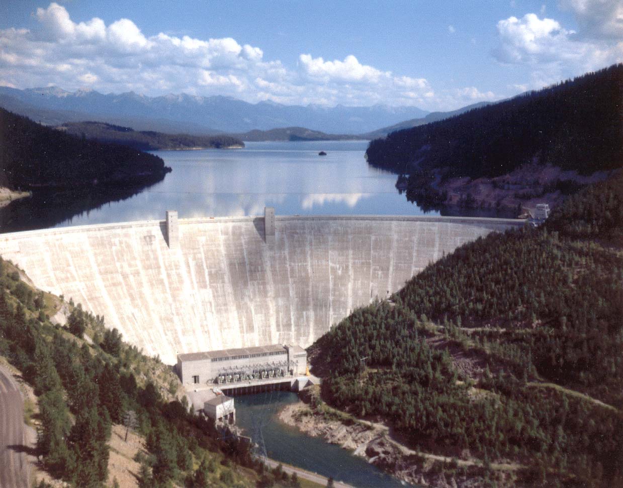
Imagine standing on a sturdy concrete wall that stretches 172 meters into the sky, with the glistening waters of Hungry Horse Reservoir spilling over the base and the snow‑capped Flathead Range looming in the distance. That’s the experience at Hungry Horse Dam—a landmark that combines the raw power of nature with human ingenuity. Whether you’re a road‑tripper cruising the Pacific Northwest, a photography enthusiast hunting dramatic vistas, or a family seeking a day of outdoor fun, this dam delivers a memorable Montana adventure.
2. About Hungry Horse Dam
Location: Columbia Falls, Montana, United States
Coordinates: 48.341213, –114.014262
Height: 172 m (≈ 564 ft)
Hungry Horse Dam sits on the South Fork Flathead River, forming the expansive Hungry Horse Reservoir. Constructed by the U.S. Army Corps of Engineers between 1948 and 1953, the dam was originally built for flood control, hydroelectric power generation, and water storage. Today, its 386‑megawatt powerhouse supplies clean energy to the Pacific Northwest while also supporting recreation and wildlife habitat.
Historical Highlights
- 1948–1953: Construction period—workers carved the arch into solid granite, creating one of the tallest concrete dams in the United States.
- 1953: The dam officially opened, instantly becoming a critical component of the region’s power grid.
- 1970s‑Present: Ongoing upgrades have kept the facility at the cutting edge of renewable energy technology.
Hungry Horse Dam isn’t just a functional structure; it’s a cultural icon for Flathead County. Its name pays homage to the “hungry horse” legend of a starving horse that survived the harsh winter near the site—a story that adds a touch of frontier folklore to the modern marvel.
3. How to Get There
By Car
Hungry Horse Dam is easily reachable via U.S. Highway 2, which runs east‑west through Columbia Falls. From Kalispell (≈ 30 km west), follow Highway 2 east and take the exit for Hungry Horse Reservoir Road. The dam’s visitor parking lot is just off this road, marked with clear signage.
| Starting Point | Approx. Distance | Approx. Driving Time |
|---|---|---|
| Kalispell, MT | 30 km (19 mi) | 30 min |
| Missoula, MT | 140 km (87 mi) | 1 hr 45 min |
| Glacier National Park (West Entrance) | 70 km (44 mi) | 1 hr 10 min |
By Air
The nearest commercial airport is Glacier Park International Airport (FCA) in Kalispell. From the airport, rent a car and follow the directions above. The drive offers scenic mountain vistas, making the short trip part of the adventure.
Public Transportation
Limited regional bus services run between Kalispell and Columbia Falls, but they do not stop directly at the dam. For the most flexibility, a rental car or rideshare is recommended.
4. Best Time to Visit
| Season | Highlights | Weather & Tips |
|---|---|---|
| Spring (April–June) | Water levels rise, creating dramatic waterfalls over the spillway; wildflowers bloom along the reservoir’s shoreline. | Expect cool mornings (5‑12 °C). Pack layers and waterproof shoes. |
| Summer (July–August) | Ideal for boating, fishing, and picnicking. Long daylight hours (up to 16 h) give plenty of time for exploration. | Warm days (20‑30 °C). Sunscreen, hat, and plenty of water are a must. |
| Fall (September–October) | Brilliant foliage of aspens and pines; quieter crowds. Perfect for photography of sunrise over the dam. | Crisp evenings (5‑10 °C). Bring a jacket for early mornings. |
| Winter (November–March) | Snow‑capped dam creates a postcard‑perfect scene; occasional ice‑fishing on the reservoir. | Sub‑zero temps; road conditions may be icy. Check weather alerts before traveling. |
Peak visitation occurs in July and August, so if you prefer a more tranquil experience, aim for late spring or early fall.
5. What to Expect
Scenic Views
The dam’s concrete arch rises dramatically against the backdrop of the Flathead Range. From the visitor overlook, you’ll see the turquoise waters of Hungry Horse Reservoir stretching for miles, dotted with islands and framed by pine forests.
Outdoor Activities
- Fishing: The reservoir is stocked with trout, kokanee salmon, and bass. Anglers can launch from the public boat ramp (permit required).
- Boating & Kayaking: Non‑motorized boats are popular; rentals are available in nearby Columbia Falls.
- Hiking: Short trails lead from the dam’s parking lot to viewpoint loops, offering easy walks for families. For the more adventurous, the Hungry Horse Trailhead provides access to longer backcountry routes.
- Picnicking: Designated picnic tables and grills are available near the overlook—perfect for a lunch with a view.
Visitor Amenities
- Parking: Free, well‑marked lot with spaces for RVs and accessible parking.
- Restrooms: Clean facilities near the main overlook.
- Information Kiosk: Staffed during summer months with brochures on hydroelectric power, wildlife, and local trail maps.
6. Nearby Attractions
While Hungry Horse Dam is the star attraction, the surrounding Flathead Valley offers several other gems worth exploring. All distances are approximate from the dam.
| Attraction | Type | Distance | Why Visit |
|---|---|---|---|
| Lion Lake South Dike | Dam | 3.4 km | A quieter spot for birdwatching and photography. |
| Lion Lake North Dike | Dam | 3.7 km | Offers a scenic walking trail along the water’s edge. |
| Cedar Creek Dam | Dam | 12.6 km | Ideal for a day‑trip picnic and fishing. |
| [Spring] (unnamed) | Spring | 16.3 km | Refreshing natural spring—great for a short hike. |
| Jessup Mill Pond Dam | Dam | 17.5 km | Historic mill pond with interpretive signage. |
Quick tip: Combine your dam visit with a drive along U.S. Highway 2 to enjoy panoramic mountain vistas and stop at these nearby sites for a well‑rounded day in the Flathead Valley.
7. Travel Tips
- Bring a Camera: The interplay of water, concrete, and mountains creates award‑winning photo opportunities—especially at sunrise and sunset.
- Check Reservoir Levels: Water levels fluctuate seasonally; low levels may limit boat launch access. The U.S. Army Corps of Engineers website provides real‑time updates.
- Pack Snacks & Water: While there are picnic tables, there are no food vendors on site. A cooler with snacks keeps you energized for hikes.
- Respect Wildlife: Bald eagles, ospreys, and deer are common around the reservoir. Keep a safe distance and avoid feeding animals.
- Dress in Layers: Montana weather can change rapidly, especially near the water. A lightweight jacket and moisture‑wicking layers work best.
- Leave No Trace: Use designated trash receptacles and stay on marked trails to preserve the pristine environment.
- Plan for Connectivity: Cell service can be spotty near the dam; download maps offline before you arrive.
Ready to Experience Hungry Horse Dam?
From its towering 172‑meter arch to the sparkling blue waters of its reservoir, Hungry Horse Dam offers a uniquely Montana experience—one that blends engineering marvels with the raw beauty of the Rocky Mountains. Pack your gear, hit the road, and discover why this dam is a must‑see destination for travelers seeking adventure, tranquility, and unforgettable scenery.
Happy travels, and may the views be as endless as the horizon!