Brower's Spring, Montana – The Hidden Headwater of the Mississippi‑Missouri River
If you’ve ever dreamed of standing at the very source of one of the world’s greatest river systems, Brower's Spring in West Yellowstone, Montana, is the place to make that dream a reality. Nestled in the rugged wilderness of the Rocky Mountains, this modest spring may look unassuming, but it holds a title that few other natural sites can claim: the ultimate headwater of the Mississippi‑Missouri River system. In this guide, we’ll explore everything you need to know to plan an unforgettable visit—from the spring’s fascinating backstory to practical travel tips and nearby attractions worth adding to your itinerary.
1. About Brower's Spring
Location: West Yellowstone, Montana, United States
Coordinates: 44.550140, -111.473719
Type: Natural spring (headwater)
Brower's Spring earned its fame thanks to the pioneering work of early 20th‑century explorer John M. Brower, who traced the most distant source of the mighty Mississippi‑Missouri watershed to this tiny, high‑country spring. While the exact altitude and height of the spring remain undocumented, its significance is crystal clear: water that bubbles out here eventually joins the Jefferson River, merges into the Missouri, and finally flows into the Mississippi, traveling more than 2,300 miles before reaching the Gulf of Mexico.
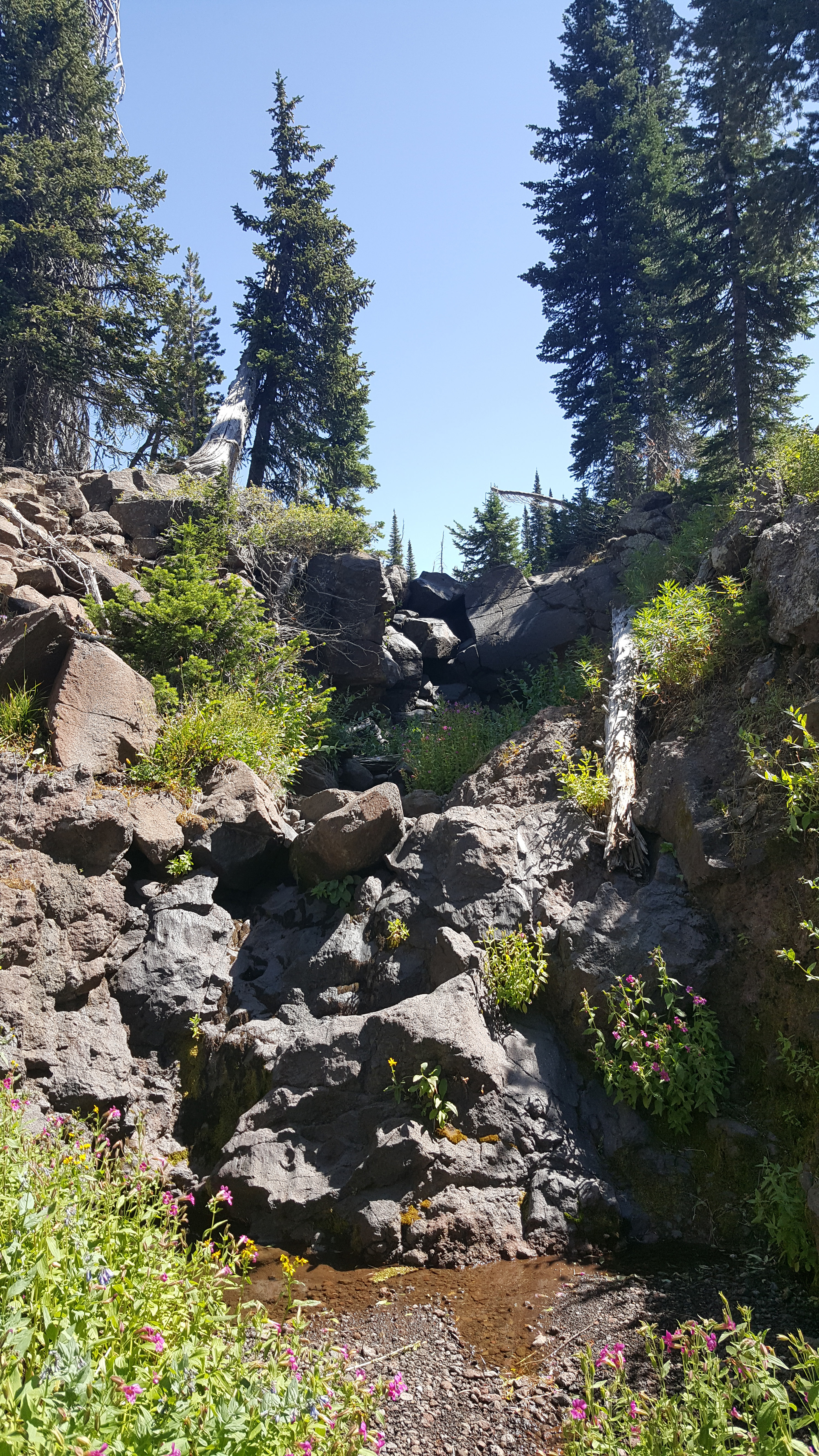
The spring sits within a pristine alpine basin, surrounded by sub‑alpine meadows, spruce‑fir forests, and dramatic volcanic peaks that dominate the Yellowstone Plateau. Because it lies in a relatively remote part of the Gallatin National Forest, visitors can expect a sense of solitude that feels far removed from the crowds of nearby Yellowstone National Park.
Quick Fact: Brower's Spring is listed on Wikipedia as “the ultimate headwater of the Mississippi–Missouri River system.”
2. How to Get There
Reaching Brower's Spring is an adventure in itself, but the journey adds to the overall experience. Here’s a step‑by‑step guide for the most common travel routes:
| Step | Details |
|---|---|
| Fly In | The closest major airport is Bozeman Yellowstone International Airport (BZN), about 90 miles (≈ 1.5‑hour drive) from West Yellowstone. Major airlines offer daily flights from Denver, Salt Lake City, and Seattle. |
| Rent a Vehicle | A reliable 4‑WD vehicle is strongly recommended. Snow‑pack and unpaved roads can appear even in late spring. |
| Drive to West Yellowstone | Take US‑191/US‑20 north from Bozeman to West Yellowstone. The town is the gateway to Yellowstone National Park and offers a range of lodging, dining, and fuel options. |
| Head to the Trailhead | From West Yellowstone, follow US‑20 west for about 12 miles, then turn onto Forest Service Road 104 (also known as the Brower’s Spring Road). This gravel road leads to a modest parking area at the trailhead. The road is seasonally maintained—check the U.S. Forest Service website for current conditions. |
| Hike In | The final approach is a short, moderate hike (≈ 0.8 miles, 300‑ft elevation gain) through alpine meadow to the spring itself. Trail markers are sparse, so bring a topographic map or a GPS device set to the coordinates 44.550140, -111.473719. |
Public Transportation: There is no public transit to the spring. Car rentals or guided tours are the only viable options.
3. Best Time to Visit
Because Brower's Spring sits at a high elevation in the Rocky Mountains, weather can be unpredictable. Here’s a seasonal breakdown:
| Season | Conditions | Why Visit |
|---|---|---|
| Late Spring (May‑June) | Snow melt creates vibrant wildflower carpets; water flow is strong. Some road sections may still be muddy. | Ideal for photography and witnessing the spring’s full vigor. |
| Summer (July‑August) | Warm days, occasional thunderstorms. Trails are clear, and the surrounding forest is lush. | Best overall hiking weather; longer daylight hours. |
| Early Fall (September‑Early Oct.) | Crisp air, golden aspen foliage, fewer crowds. Snow may start to appear at higher elevations. | Perfect for serene, colorful landscapes. |
| Winter (Nov‑April) | Snow-covered roads, deep snowpack, limited access. Only experienced backcountry skiers or snowshoers should attempt. | Not recommended for casual visitors. |
Peak Visitor Window: Mid‑July to early September offers the most reliable road access, comfortable temperatures, and abundant wildlife viewing.
4. What to Expect
Arriving at Brower's Spring feels like stepping into a living piece of geography textbook. Here’s what you’ll experience:
- Crystal‑Clear Waters – The spring bubbles from a small, moss‑lined pool. The water is icy cold, reflecting the surrounding sky like a mirror.
- Alpine Quiet – Apart from the gentle rush of the spring and occasional bird calls, the area is remarkably quiet. The sense of isolation is profound.
- Panoramic Views – From the spring, you can glimpse the surrounding ridgelines of the Gallatin Range and, on clear days, the distant silhouette of Mount Jefferson.
- Wildlife – Expect to see elk, mule deer, and possibly a black bear foraging in the meadow. Early morning is the best time for wildlife sightings.
- Interpretive Signage – A modest plaque near the spring explains its significance as the headwater of the Mississippi‑Missouri River system.
Because the spring is a protected water source, visitors are asked to stay on established paths, pack out all trash, and avoid contaminating the water. The area is not developed with restrooms or picnic facilities, so come prepared.
5. Nearby Attractions
While Brower's Spring is the star of the show, the surrounding region offers several compelling side trips. All are within a 15‑km radius and make excellent day‑trip stops:
- Coffee Pot Rapids – 8.6 km away, these lively rapids on the Madison River provide a dramatic contrast to the tranquil spring. Ideal for a quick photo stop or a short riverside walk.
- Henrys Lake Dam – 10.9 km away, this dam creates a pristine alpine lake perfect for fishing, kayaking, and picnicking.
- Icehouse Creek Dam (Idaho) – 14.8 km away, located just across the state line, offering scenic views of the Snake River watershed.
- Culver Springs Dam (Montana) – 15.7 km away, a quiet spot for birdwatchers and anglers.
(Note: One unnamed dam 14.5 km away in Idaho is omitted due to lack of a specific name.)
These attractions can be combined into a “Western Montana Waterways Loop,” giving you a fuller picture of the region’s hydrology and natural beauty.
6. Travel Tips
| Tip | Details |
|---|---|
| Pack Layers | Weather can shift from sunny to stormy within minutes. Bring a waterproof jacket, insulated layers, and sun protection. |
| Bring Water Filtration | While the spring water is pristine, it’s advisable to carry a lightweight filter if you plan to drink directly from natural sources. |
| Leave No Trace | Use biodegradable soap, pack out all trash, and avoid disturbing vegetation. |
| Check Road Conditions | The Forest Service updates road status on the U.S. Forest Service – Gallatin National Forest website. Call ahead during spring melt. |
| Cell Service | Expect limited or no cellular coverage near the spring. Download offline maps (e.g., Google Maps offline area or a topographic map app). |
| Safety | Wildlife encounters are common. Carry bear spray, store food in bear‑proof containers, and make noise while hiking. |
| Timing | Arrive early (before 10 am) to beat any afternoon thunderstorms and to enjoy the soft morning light for photography. |
| Guided Tours | If you prefer not to navigate the backcountry alone, several local outfitters in West Yellowstone offer guided day hikes to Brower's Spring. |
7. Final Thoughts
Brower's Spring may not have the grand visitor centers or dramatic waterfalls of more famous national park sites, but its geographic significance and raw wilderness charm make it a hidden gem for the intrepid traveler. Standing at the very point where water begins its epic journey to the Gulf of Mexico is a humbling reminder of the interconnectedness of our natural world.
Whether you’re a geography enthusiast, a seasoned backpacker, or simply a curious wanderer seeking a slice of Montana’s untamed beauty, Brower's Spring offers a unique, soul‑refreshing experience. Pack your boots, charge your camera, and set your compass for 44.550140 N, ‑111.473719 W—your adventure to the ultimate headwater awaits.
Happy trails!
Keywords: Brower's Spring, Montana spring, Mississippi-Missouri River headwaters, West Yellowstone travel, Gallatin National Forest, Colorado River source, hiking Montana, spring water source, travel guide Montana, nearby attractions West Yellowstone.