Rapidan Dam, Minnesota – A Hidden Gem for Water‑Lovers and Adventure Seekers
Coordinates: 44.092668, ‑94.108302 | Height: 27 m | Type: Concrete gravity dam
Introduction
If you’ve ever driven through the rolling prairies of southern Minnesota and felt the pull of a river’s gentle roar, you’ve already sensed the charm of the Rapidan Dam. Tucked just a few miles north of Mankato, this modest‑sized dam may not boast the fame of the Mississippi’s mighty locks, but it offers a quiet, off‑the‑beaten‑path experience that blends engineering history, scenic river views, and easy access to a cluster of spectacular waterfalls. Whether you’re a road‑trip enthusiast, a photography hobbyist, or a family looking for a day‑trip with a splash of adventure, Rapidan Dam should be on your Minnesota travel radar.
About Rapidan Dam
Built as a 27‑metre (≈ 89 ft) concrete gravity dam, Rapidan Dam was originally constructed to regulate water flow on the Rapidan River, a tributary that winds through the fertile farmlands of Blue Earth County. While the exact year of construction is not widely documented, the dam has served local agriculture and recreation for decades, helping to maintain steady water levels for downstream farms and providing a modest hydro‑electric output for the surrounding community.
In June 2024, the dam experienced a structural failure (recorded as “Failed Dam: 2024/06/24”). The incident prompted a temporary closure of the immediate area while engineers assessed safety and repair options. As of this writing, the site is open for viewing from a safe distance, and the surrounding parkland remains accessible for hikers, birdwatchers, and picnickers. The recent event adds a layer of modern history to the dam, making it an intriguing spot for those who appreciate the evolving story of America’s water infrastructure.
Why it matters:
- Local heritage: The dam reflects early‑20th‑century engineering practices that helped shape Minnesota’s agricultural prosperity.
- Scenic backdrop: Its modest height creates a picturesque cascade that mirrors the sky—perfect for sunrise and sunset photography.
- Gateway to waterfalls: Within a 10‑km radius, you’ll find five stunning waterfalls, each offering a unique perspective on Minnesota’s glacially carved landscape.
For a deeper dive into the dam’s background, check out its Wikipedia entry: Rapidan Dam – Wikipedia.
How to Get There
By Car
| Starting Point | Approx. Distance | Directions |
|---|---|---|
| North Mankato, MN | 2 mi (≈ 3 km) | From downtown, head north on US‑169. Take the County Road 8 exit, turn left onto County Road 8 (Ridge Road), and follow the signs for Rapidan Dam. |
| Mankato, MN | 5 mi (≈ 8 km) | Take US‑169 North toward North Mankato, then follow the same route as above. |
| Minneapolis, MN | 80 mi (≈ 130 km) | Take I‑35W South to I‑35 South, exit onto US‑169 South at New Prague, then continue to North Mankato. |
Parking is available in a small lot adjacent to the dam’s viewing platform. The lot fills quickly on sunny weekends, so arriving early (7 – 8 am) is advisable.
Public Transportation
Minnesota’s Southwest Transit offers limited bus service to North Mankato on weekdays. The nearest stop is the North Mankato Transit Center; from there, a short taxi or ride‑share (Uber/Lyft) ride will get you to the dam in under 10 minutes.
Biking & Hiking
The dam sits along the Rapidan River Trail, a 6‑mile multi‑use path that connects the Mankato Riverfront to the dam’s parkland. Cyclists can enjoy a gentle, mostly flat ride with occasional river views. Bring a bike lock, as the parking area has limited bike racks.
Best Time to Visit
| Season | Highlights | Tips |
|---|---|---|
| Spring (April‑May) | Snowmelt swells the river, creating a lively flow over the dam. Wildflowers begin to bloom along the banks. | Wear waterproof shoes; the trail can be muddy. |
| Summer (June‑August) | Warm weather makes for perfect picnics. Longer daylight hours allow for sunset photography at the dam. | Bring sunscreen, hats, and plenty of water. |
| Fall (September‑October) | The surrounding woods turn brilliant shades of orange, red, and gold—ideal for landscape shots. | Pack a light jacket; evenings can be crisp. |
| Winter (November‑March) | The dam may be covered in ice, offering a stark, serene view. Nearby waterfalls become frozen spectacles. | Check road conditions; some access roads may be closed due to snow. |
Peak visitor months are July and August, so if you prefer a quieter experience, aim for late May, early September, or the shoulder months of April and October.
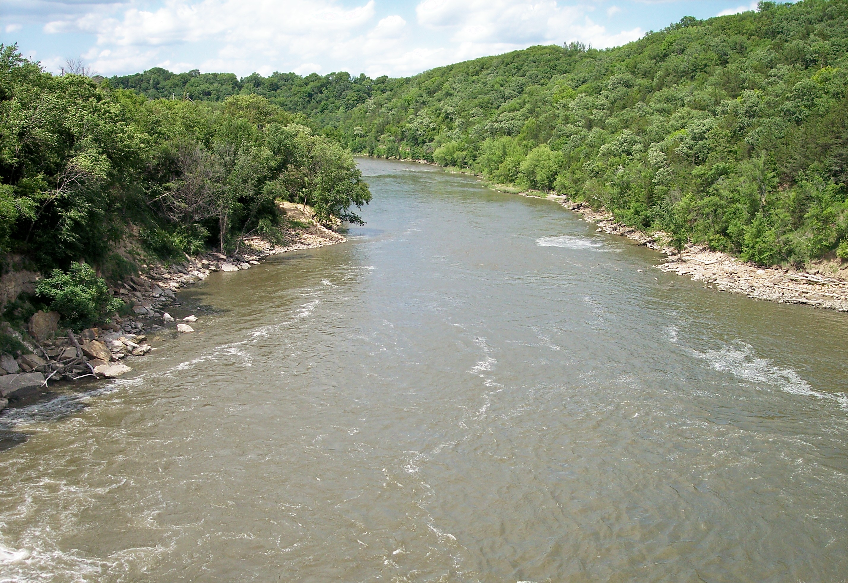
What to Expect
When you arrive at Rapidan Dam, you’ll be greeted by a well‑maintained park that balances natural beauty with subtle interpretive signage. The main viewing platform sits a short walk from the parking lot, offering a panoramic vista of the dam’s concrete wall and the river’s gentle cascade. From this spot, you can:
- Listen to the river’s rhythm: The controlled flow creates a soothing, steady murmur—great for meditation or background noise while you sketch or write.
- Spot wildlife: Look up for bald eagles soaring overhead, or keep an eye on the riverbanks for beavers, otters, and a variety of waterfowl.
- Capture photos: The dam’s geometric lines contrast beautifully with the organic shapes of surrounding trees, especially during sunrise or golden hour.
- Learn the story: Small interpretive panels explain the dam’s construction, its role in local agriculture, and the 2024 failure event, giving context to the engineering marvel you’re viewing.
Because of the 2024 structural issue, direct access to the spillway and the water’s edge is restricted for safety. However, the surrounding trails remain open, and you can still enjoy the sound and sight of water flowing over the dam’s crest from a safe distance.
Nearby Attractions
A short drive (or a leisurely hike) from Rapidan Dam brings you to five remarkable waterfalls—each a perfect side‑trip for nature lovers.
| Waterfall | Distance from Dam | Highlights | Link |
|---|---|---|---|
| Bigger Manitou Falls | 1.8 km | A robust, 12‑meter drop surrounded by rugged limestone outcrops. | Bigger Manitou Falls – Wikipedia |
| Triple Falls | 2.8 km | Three cascading tiers that create a natural stair‑like effect—great for slow‑motion video. | Triple Falls – Wikipedia |
| Upper Minneopa Falls | 6.4 km | The upper tier of the iconic Minneopa Falls, offering a quieter, less‑crowded experience. | Upper Minneopa Falls – Wikipedia |
| Lower Minneopa Falls | 6.4 km | The main attraction of Minneopa State Park; a 16‑meter plunge that’s a favorite photo spot. | Lower Minneopa Falls – Wikipedia |
| Minnemishinona Falls | 8.8 km | A hidden gem tucked in a forested ravine, perfect for a peaceful picnic. | Minnemishinona Falls – Wikipedia |
Travel tip: Combine the dam visit with a waterfall loop—start at Rapidan Dam, head east to Bigger Manitou Falls, then loop north to Triple Falls, and finish with a drive to Minneopa State Park for lunch and a dip in the river (if weather permits).
Travel Tips
- Safety First – The dam’s spillway is off‑limits due to the 2024 failure. Stick to marked trails and respect any posted barriers.
- Parking – The lot fills quickly on weekends. Arrive early or consider visiting on a weekday for easier access.
- Bring Snacks & Water – While there are a few picnic tables, there are no food vendors on site. A reusable water bottle and a packed lunch will keep you energized.
- Dress for the Weather – The area can be windy, especially near the river. Layered clothing works best.
- Photography Gear – A wide‑angle lens captures the dam’s structure, while a telephoto lens is ideal for wildlife and waterfall details. A tripod helps with low‑light shots at sunrise or sunset.
- Leave No Trace – Pack out all trash, stay on designated paths, and avoid disturbing the riverbank vegetation.
- Check Road Conditions – In winter, snow and ice can make County Road 8 slippery. Local weather apps or the Minnesota Department of Transportation website provide up‑to‑date road reports.
- Local Eats – After exploring, head to downtown North Mankato for a bite. The River’s Edge Café offers river‑view dining, and Mankato Brewing Company serves locally‑crafted beers—perfect for unwinding after a day of adventure.
Wrap‑Up
Rapidan Dam may not dominate travel guide headlines, but its blend of historic engineering, tranquil river scenery, and proximity to multiple waterfalls makes it a standout destination for anyone traveling through southern Minnesota. Whether you’re snapping photos, listening to the river’s lullaby, or using the dam as a launchpad for a waterfall‑hopping adventure, you’ll leave with a deeper appreciation for the hidden waterways that shape the Land of 10,000 Lakes.
Pack your camera, map out the waterfall loop, and set your GPS to 44.092668, ‑94.108302—the heart of a quiet, captivating Minnesota treasure awaits. Safe travels!