Sault Canal Emergency Swing Dam: A Hidden Engineering Marvel in Michigan’s Upper Peninsula
If you think Michigan’s attractions are limited to Great Lakes beaches and cherry orchards, think again. Nestled on the banks of the St. Marys River, the Sault Canal Emergency Swing Dam offers a rare glimpse into 19th‑century engineering, dramatic river history, and a perfect launchpad for exploring the vibrant town of Sault Ste. Marie.
1. Introduction
Imagine standing on a quiet riverbank where a massive steel structure once pivoted like a giant gate, ready to protect a bustling canal from catastrophic flooding. That’s the Sault Canal Emergency Swing Dam—a modest‑sized, yet historically pivotal, dam in Michigan that played a crucial role in safeguarding the world‑famous Soo Locks. While it doesn’t boast towering heights or a visitor center, its story is woven into the fabric of North American maritime trade, making it a must‑see for history buffs, photography lovers, and off‑the‑beaten‑path travelers alike.
2. About Sault Canal Emergency Swing Dam
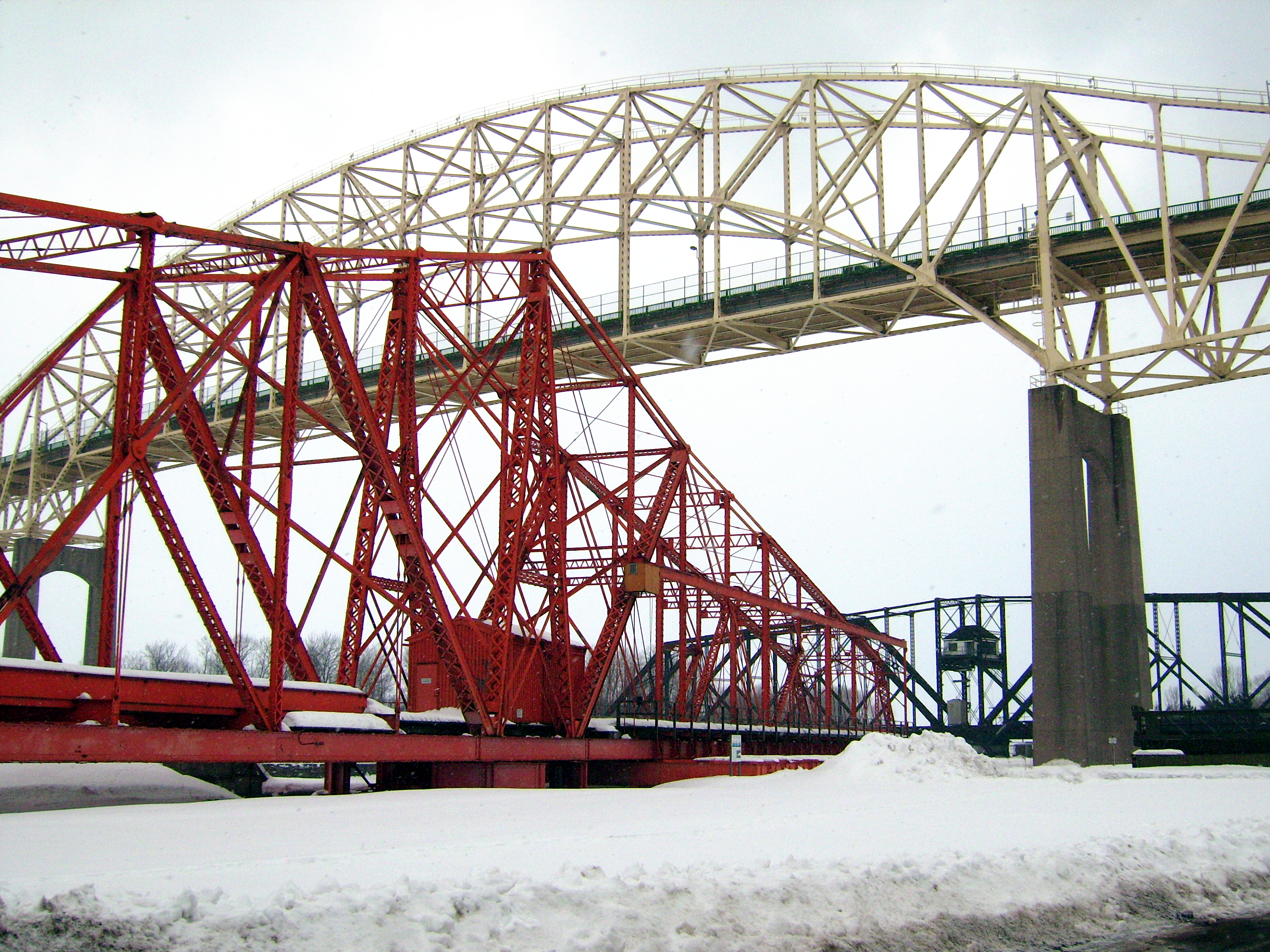
A Brief History
Built in the late 1800s as a safety net for the Soo Locks, the Sault Canal Emergency Swing Dam was designed to swing into place across the St. Marys River whenever a sudden surge threatened the canal system. Its primary purpose was to prevent uncontrolled water flow that could damage the locks—critical passageways that allow ships to navigate the 21‑foot drop between Lake Superior and the lower Great Lakes.
Unlike permanent dams, this swing dam was emergency‑only: it remained idle until a rapid rise in water level demanded action. When deployed, massive steel arms rotated around a central pivot, forming a temporary barrier that could be quickly removed once conditions stabilized.
Why It Matters
- Engineering Innovation – At a time when hydraulic technology was still in its infancy, the swing dam represented a clever, mechanical solution to a pressing safety issue.
- Economic Impact – By protecting the Soo Locks, the dam indirectly safeguarded the shipping lanes that move millions of tons of iron ore, grain, and other commodities each year.
- Cultural Heritage – The structure is a tangible reminder of the Upper Peninsula’s industrial past and the relentless human effort to tame the powerful Great Lakes waterways.
Although the dam is no longer in active service, its rust‑patinated steel skeleton still stands as a silent sentinel, inviting curious travelers to step back in time.
3. How to Get There
By Car
- From the U.S.: Take I‑75 north to US‑2/US‑141 (the “Soo Highway”) and follow signs for Sault Ste. Marie, MI. The dam sits just a short drive from the downtown area—approximately 0.6 km from the city center.
- From Canada: Cross the Sault Ste. Marie International Bridge into Michigan and continue on US‑2/US‑141 southbound.
Parking & Access
- Street Parking: Limited metered spots line the adjacent streets; arrive early during peak tourist season (summer weekends) to secure a space.
- Public Lot: The Sault Ste. Marie Visitor Center lot (a few blocks east) offers free daytime parking and a short walk to the dam.
Public Transportation
- Local Bus: The Sault Ste. Marie Transit Authority runs Route 4, which stops within a five‑minute walk of the dam’s entrance. Check the latest schedule on the city’s website.
Walking & Biking
The dam is easily reachable on foot or by bike from downtown Sault Ste. Marie. The St. Marys River Trail provides a scenic, paved route that runs alongside the river, perfect for a leisurely stroll before or after your dam visit.
4. Best Time to Visit
| Season | Highlights | Visitor Tips |
|---|---|---|
| Spring (April–May) | River water levels rise, creating dramatic reflections on the dam’s steel. Fewer crowds. | Dress in layers; early mornings can be chilly. |
| Summer (June–August) | Warm weather, longer daylight, and nearby festivals (e.g., Soo Locks Summer Fest). | Arrive early to beat the midday heat and secure parking. |
| Fall (September–October) | Brilliant foliage along the St. Marys River, perfect for photography. | Bring a tripod for low‑light shots of the dam against sunset colors. |
| Winter (November–March) | Snow‑covered landscape offers a serene, almost mystical vibe. Limited daylight. | Check road conditions; some access points may be snow‑plowed but still icy. |
Overall Recommendation: Late May through early October provides the most comfortable weather and vibrant scenery, making it the ideal window for most travelers.
5. What to Expect
When you arrive, you’ll be greeted by the rust‑streaked steel framework of the swing dam, set against the flowing St. Marys River. The site is unfenced, allowing close-up views and photo opportunities from multiple angles.
- Interpretive Signage – Small plaques explain the dam’s function, its historical context, and its relationship to the Soo Locks.
- River Sounds – The constant murmur of the river creates a soothing backdrop, especially during sunrise or sunset.
- Photography – The juxtaposition of industrial metal and natural water makes for compelling shots. Capture the dam’s silhouette against a pink dawn sky or frame it with autumn leaves drifting downstream.
While there is no guided tour, the area is safe for self‑guided exploration. Keep an eye out for occasional maintenance crews, and respect any posted “No Trespassing” signs near operational lock areas.
6. Nearby Attractions
Your visit to the Sault Canal Emergency Swing Dam can easily become a full‑day adventure thanks to several points of interest within walking distance.
| Attraction | Distance | Why Visit? |
|---|---|---|
| Saint Marys Falls (waterfall) | 0.7 km | A stunning 21‑foot cascade that gives the river its name; great for picnics and photo ops. |
| Soo Locks | ~1 km | Witness massive ships navigate the lock system—an engineering marvel in its own right. |
| Unit No. 10 Dam | 1.0 km | Another historic dam offering insight into regional water management. |
| Canadian Dam (Ontario) | 0.8 km (across the border) | A quick glimpse of the river’s twin‑nation infrastructure; viewable from the U.S. side. |
| Downtown Sault Ste. Marie | <1 km | Explore boutique shops, local cafés, and the Sault Ste. Marie Museum for deeper cultural context. |
All distances are approximate walking distances from the swing dam.
7. Travel Tips
- Bring a Good Camera – The dam’s industrial textures and river reflections reward both wide‑angle and macro lenses.
- Wear Comfortable Shoes – The site is on uneven ground near the riverbank; sturdy walking shoes or hiking boots are ideal.
- Check Weather Forecasts – River levels can rise quickly after heavy rain; avoid visiting during severe storms.
- Carry a Light Jacket – Even summer evenings can get breezy along the water.
- Stay Hydrated – There are limited vending options near the dam; bring water, especially if you plan to explore nearby attractions on foot.
- Respect the Locks – The Soo Locks are an active commercial facility. Observe all safety barriers and follow posted signage.
- Plan for a Full Day – Pair your dam visit with a stroll to Saint Marys Falls, a quick tour of the Soo Locks, and lunch at a downtown eatery (try the local whitefish sandwich).
Final Thought
The Sault Canal Emergency Swing Dam may not have the towering grandeur of Niagara or the fame of the Hoover Dam, but its quiet presence tells a compelling story of ingenuity, safety, and the relentless drive to keep Great Lakes commerce moving. Whether you’re a history enthusiast, a photography aficionado, or simply a traveler looking for a unique slice of Michigan’s Upper Peninsula, this hidden dam offers a rewarding, off‑the‑radar experience that enriches any Great Lakes itinerary.
Pack your camera, follow the river’s edge, and let the swing dam swing you back in time. Safe travels!