Miners Falls – Michigan’s Hidden Cascade in the Heart of Pictured Rocks
If you’re chasing the roar of water and the scent of pine in Michigan’s Upper Peninsula, Miners Falls is the secret splash you’ve been waiting for.
Introduction
Nestled just a short drive from the charming town of Munising, Miners Falls is a modest yet mesmerizing waterfall that drops into a moss‑laden gorge, framed by towering cliffs of red sandstone. While it doesn’t boast the height of a Niagara, its intimate setting and easy‑access trail make it a favorite stop for families, photographers, and anyone looking to soak up the natural beauty of the Upper Peninsula. In this guide, we’ll walk you through everything you need to know to experience Miners Falls like a local— from the best time to visit to nearby hidden gems you won’t want to miss.
About Miners Falls
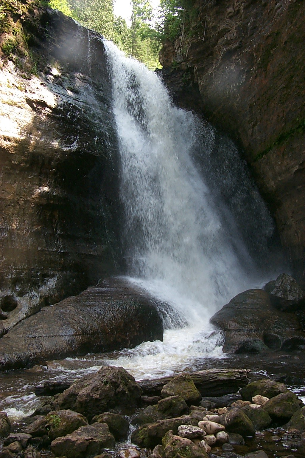
Miners Falls is part of the Pictured Rocks National Lakeshore, a protected stretch of shoreline along Lake Superior renowned for its colorful cliffs, sea‑stack formations, and pristine forests. The falls sit on the Miners River, which carves a dramatic gorge before emptying into Lake Superior. Though the exact height of the cascade isn’t officially recorded, the waterfall drops a comfortable distance that creates a steady curtain of water—perfect for that classic “waterfall selfie.”
Historically, the area around the falls was a hub for iron‑ore mining in the late 19th and early 20th centuries. The name “Miners” pays homage to the hardworking men who once trekked these woods to extract the region’s rich mineral resources. Today, the site serves as a peaceful reminder of that industrious past, with interpretive signs along the trail that explain both the geological forces that shaped the gorge and the cultural history of the mining community.
How to Get There
By Car
- Start in Munising, MI – The town is the gateway to Pictured Rocks and offers several lodging options, restaurants, and a visitor center.
- Take H‑58 West – Follow the scenic highway toward the falls. The road is well‑maintained and clearly signed for “Miners Falls.”
- Turn onto Miners Falls Road – After about 2 miles, you’ll see a small parking lot on the left. The lot holds roughly 20 vehicles, so arrive early in peak season (July–August) to secure a spot.
Coordinates: 46.474725, -86.531409 – Plug these into your GPS for pinpoint accuracy.
Public Transportation
While there’s no direct bus service to the falls, the Marquette County Transit system connects Munising with neighboring towns. From the Munising bus depot, you can rent a bike or grab a rideshare (Uber/Lyft) for the short 5‑minute drive to the trailhead.
Accessibility
The trail to Miners Falls is a moderately easy, 0.6‑mile loop that is wheelchair‑accessible in most sections, though the final approach to the viewing platform includes a short set of stairs. The path is well‑graded, with boardwalk sections that keep you dry even after a rain shower.
Best Time to Visit
| Season | What to Expect | Why It’s Ideal |
|---|---|---|
| Late Spring (May‑June) | Water flow is at its peak from snowmelt; vibrant wildflowers line the trail. | The falls are loudest and the surrounding forest is a riot of color. |
| Summer (July‑August) | Warm days, longer daylight, and fully open trail facilities. | Perfect for family outings and photography with soft evening light. |
| Fall (September‑October) | Brilliant foliage—reds, oranges, and yellows—reflect off the water. | The cooler air makes hiking comfortable, and crowds thin out. |
| Winter (November‑April) | Snow‑covered gorge creates a serene, icy tableau; the trail may be icy. | For the adventurous, a snowshoe or cross‑country ski trek offers a unique perspective. |
Tip: The waterfall’s roar is most impressive during spring melt, but if you prefer milder crowds, aim for early September.
What to Expect
As you step onto the boardwalk, the first thing you’ll notice is the gentle mist that rises from the falling water, cooling the air around you. The trail follows the river’s edge, winding through a mixed‑hardwood forest of birch, maple, and towering pines. The sound of the cascade builds gradually, culminating in a satisfying rush as you reach the viewing platform.
From the platform, you can see the water plunging over a rocky ledge into a shallow pool below, framed by sugar‑maple leaves that turn fiery in autumn. The gorge walls are a deep, reddish sandstone, a hallmark of the Pictured Rocks region, and they catch the sunlight in a way that makes the whole scene glow.
Photography enthusiasts love the soft, diffused light that filters through the canopy, especially during the “golden hour” just before sunset. For hikers, the loop offers a gentle cardio workout without steep climbs, making it suitable for all ages.
Nearby Attractions
After you’ve taken in the beauty of Miners Falls, explore these neighboring natural wonders—each just a short drive away:
- Miners River Waterfall – 2.0 km away. A quieter cascade further upstream, perfect for a quiet picnic.
- Elliot Falls (waterfall) – 2.8 km away. A rugged, lesser‑known waterfall that rewards adventurous hikers.
- Bridalveil Falls (waterfall) – 3.8 km away. Known for its delicate veil‑like sheet of water, especially striking after a rainstorm.
- Sweet Mother Moses Falls (waterfall) – 4.4 km away. A whimsical name for a waterfall that tumbles over a series of small ledges, creating a playful soundscape.
All of these sites are reachable via the same H‑58 corridor, allowing you to craft a full‑day “waterfall tour” of the Upper Peninsula’s most photogenic spots.
Travel Tips
| Tip | Why It Matters |
|---|---|
| Wear sturdy, waterproof shoes | The boardwalk can be slick from spray; good traction keeps you safe. |
| Bring a reusable water bottle | There are no drinking fountains at the trailhead, and staying hydrated is key, especially in summer. |
| Pack a lightweight rain jacket | Even on sunny days, mist from the falls can make you damp; a breathable jacket helps you stay comfortable. |
| Arrive early in peak season | Parking fills up quickly from mid‑morning to early afternoon. |
| Respect the wildlife | The area is home to white‑tailed deer, red‑winged blackbirds, and occasional black bears. Keep food sealed and stay on marked paths. |
| Leave no trace | Pack out all trash, and avoid picking plants or disturbing the natural rock formations. |
| Check the National Lakeshore website | Seasonal closures or trail maintenance updates are posted there, especially in winter. |
| Bring a tripod | For low‑light shots of the waterfall at dusk, a stable tripod will dramatically improve your photos. |
| Consider a guided hike | The Pictured Rocks National Lakeshore Visitor Center offers seasonal ranger‑led walks that add historical context to your visit. |
Quick Checklist
- ☐ Map or GPS (coordinates: 46.474725, -86.531409)
- ☐ Waterproof hiking shoes
- ☐ Light rain jacket or poncho
- ☐ Reusable water bottle & snacks
- ☐ Camera or smartphone with extra battery
- ☐ Small backpack for trash (Leave No Trace)
Final Thoughts
Miners Falls may not be the tallest waterfall in Michigan, but its accessible trail, enchanting mist, and dramatic sandstone backdrop make it a must‑see for anyone traveling through the Upper Peninsula. Pair it with a scenic drive along H‑58, stop for a bite in Munising, and you’ve got a perfect day of nature, history, and photo ops.
Whether you’re a first‑time visitor to Pictured Rocks or a seasoned explorer hunting the region’s hidden gems, Miners Falls offers a refreshing splash of adventure that’s easy to fit into any itinerary. So lace up your boots, grab your camera, and let the sound of the water guide you to one of Michigan’s most charming waterfalls.
Happy trails!


