Crystal Falls Dam – A Hidden Gem in Michigan’s Upper Peninsula
Explore the historic dam, soak up the natural beauty, and discover nearby waterfalls that make this spot a must‑visit for road‑trippers, photographers, and outdoor lovers alike.
1. Introduction
If you think Michigan’s Upper Peninsula is only about rugged shorelines and dense forests, think again. Nestled in the heart of Crystal Falls, Michigan, the Crystal Falls Dam (coordinates 46.106448, ‑88.334526) offers a quiet yet striking slice of engineering history framed by crystal‑clear water and towering pines. Whether you’re chasing the perfect sunrise shot, mapping a road‑trip itinerary, or simply craving a peaceful spot to stretch your legs, this modest dam packs a punch of scenery and local charm that’s often overlooked by mainstream travel guides.
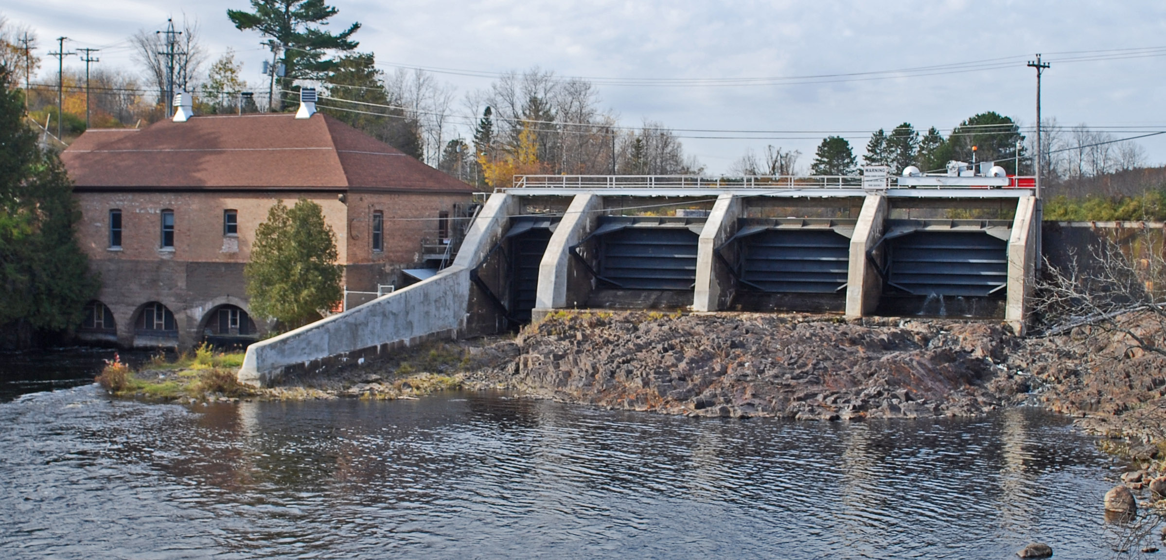
2. About Crystal Falls Dam
The Crystal Falls Dam and Power Plant is more than a concrete barrier; it’s a piece of the region’s industrial heritage. Built to harness the power of the Paint River, the dam helped fuel the early 20th‑century logging and mining boom that shaped the Upper Peninsula’s economy. While the exact height and altitude of the structure remain undocumented, its presence is unmistakable—a low‑profile concrete wall that gently tames the river’s flow, creating a tranquil reservoir that reflects the surrounding forest canopy.
Today, the dam continues to generate hydroelectric power, feeding clean energy into the local grid. Its historic significance is highlighted on its Wikipedia page, which details the engineering milestones and community impact of the facility. For travelers, the dam offers a glimpse into how nature and technology can coexist, making it an ideal stop for history buffs and eco‑enthusiasts alike.
3. How to Get There
By Car
- From Iron Mountain (≈ 35 mi): Take US‑141 N to M‑69 W, then follow the signs to Crystal Falls. The drive is scenic, winding through rolling hills and dense woodlands.
- From Marquette (≈ 70 mi): Head west on US‑41, then turn north onto M‑69. The route passes several small towns where you can stop for a coffee or a bite.
The dam sits just off M‑69, with clear signage directing you to a small parking area on the river’s east bank. The road is well‑maintained year‑round, but winter snow can make travel slower, so allow extra time if you’re visiting between December and February.
By Air
The nearest commercial airport is Gogebic‑Iron County Airport (IWD) in Iron River, about 30 mi away. From the airport, rent a car and follow the directions above. Small regional airports in Marquette and Green Bay also provide convenient gateways for out‑of‑state visitors.
Public Transportation
Public transit options are limited in this part of the Upper Peninsula. If you’re relying on buses, the Indian Trails line runs through Crystal Falls, but you’ll still need a taxi or rideshare to reach the dam itself.
4. Best Time to Visit
| Season | What to Expect | Why It’s Ideal |
|---|---|---|
| Spring (April‑May) | Snowmelt raises water levels, creating gentle rapids and lush green surroundings. | Perfect for photography of mist‑kissed waterfalls and vibrant foliage. |
| Summer (June‑August) | Warm days, longer daylight, and calm waters. | Ideal for picnics, kayaking nearby, and exploring the surrounding trails. |
| Fall (September‑October) | Brilliant orange, red, and gold leaves frame the dam. | The colors make for dramatic landscape shots; crowds are thin. |
| Winter (November‑March) | Snow‑covered trees and a quiet, frozen river. | A peaceful, almost mystical atmosphere for winter walkers—just dress warmly! |
Overall, late spring through early fall offers the most comfortable weather and the richest visual palette, but each season brings its own charm.
5. What to Expect
Arriving at Crystal Falls Dam, you’ll first notice the gentle hum of water flowing over the spillway—a soothing backdrop for any outdoor activity. The parking area is modest but sufficient for a few cars, and a short, well‑marked trail leads you to a viewing platform that offers unobstructed vistas of the reservoir and the surrounding forest.
- Scenic Views: The dam’s low profile allows the natural landscape to dominate the scene. On clear days, you can see the distant silhouette of the Iron River valley, while sunrise paints the water in gold and pink hues.
- Photography: The combination of engineered structure and natural beauty makes for compelling compositions. Bring a wide‑angle lens for the expansive river view, and a telephoto lens if you want to capture wildlife that frequents the water’s edge.
- Wildlife: Expect to see loons, ducks, and occasionally a bald eagle soaring overhead. The river’s banks are a favorite spot for anglers, so you might spot someone casting a line.
- Quiet Recreation: The area is perfect for a leisurely picnic, a short hike, or simply a moment of contemplation. There are no commercial vendors on site, so packing your own snacks and water is advisable.
Because the dam is still an operational hydro‑electric facility, you’ll notice safety railings and informational plaques explaining the power generation process. These signs provide a quick educational stop for curious minds, especially families traveling with kids.
6. Nearby Attractions
Crystal Falls Dam sits in a cluster of natural wonders, making it an excellent base for a day‑long adventure. Here are the top nearby spots (all within a 10 km radius) that you can easily combine into a single itinerary:
| Attraction | Distance | What to See | Link |
|---|---|---|---|
| Hemlock Falls Dam | 8.9 km | Another historic dam surrounded by hemlock groves; great for quiet walks. | Hemlock Falls Dam |
| Way Dike E | 9.5 km | Small dike offering a glimpse of local water management. | Way Dike E |
| Way Dam | 9.6 km | A functional dam with scenic river bends—ideal for photography. | Way Dam |
| Way Dike F | 9.7 km | Slightly off‑the‑beaten‑path spot perfect for birdwatching. | Way Dike F |
| Chicagon Falls | 9.7 km | A picturesque waterfall cascading over limestone; a must‑see for nature lovers. | Chicagon Falls |
Tip: Pack a lightweight backpack with water, snacks, and a map. The distances are short enough to walk for the more adventurous, but a short drive will let you maximize the number of sites you visit.
7. Travel Tips
- Check Road Conditions – The Upper Peninsula can experience sudden snowstorms, especially in late fall and early winter. Visit the Michigan Department of Transportation (MDOT) website for real‑time updates before you set out.
- Bring a Picnic – There are no food vendors at the dam, so bring a packed lunch. A blanket and a thermos of hot coffee make for a cozy sunrise experience.
- Dress in Layers – Even in summer, mornings can be cool near the water. A light jacket and moisture‑wicking shirt will keep you comfortable.
- Stay Charged – Cell service is spotty in some parts of the Upper Peninsula. Download offline maps (Google Maps or Maps.me) and charge your phone beforehand.
- Respect the Environment – The dam area is part of a working hydro‑electric plant. Stay on marked paths, obey signage, and avoid littering to preserve the pristine setting.
- Timing for Photography – The “golden hour” (30 minutes after sunrise or before sunset) provides the best light for capturing the dam’s reflection on the water.
- Combine with Local Culture – After your dam tour, swing by downtown Crystal Falls for a bite at a local diner or browse the Crystal Falls Historical Museum for deeper insight into the region’s past.
Final Thought
Crystal Falls Dam may not have the towering height of the world’s most famous dams, but its blend of historic significance, tranquil scenery, and proximity to other natural attractions makes it a standout stop on any Michigan Upper Peninsula itinerary. Pack your camera, hit the road, and let the gentle rush of the Paint River guide you into a uniquely peaceful corner of the Great Lakes State.
Happy travels!
