Feather Falls, California – A Hidden Cascade Worth the Journey
Discover the towering 125‑meter plunge of Feather Falls, the secret jewel of Berry Creek, and learn how to make the most of your adventure in the Sierra Nevada.
Introduction
If you’ve ever dreamed of standing beneath a waterfall that feels like a scene straight out of a movie, Feather Falls is the place to make that dream real. Nestled in the rugged foothills of the Sierra Nevada near the quiet community of Berry Creek, this 124.97 m (410 ft) cascade drops with a thunderous roar that echoes through the pine‑scented forest. Unlike the crowded tourist hotspots of Yosemite or Napa, Feather Falls offers solitude, pristine nature, and a rewarding hike that feels like a private invitation from the great outdoors.
In this guide we’ll walk you through everything you need to know: the waterfall’s story, how to reach it, the best seasons to visit, what you’ll see on the trail, nearby attractions, and essential travel tips to keep your trip smooth and unforgettable.
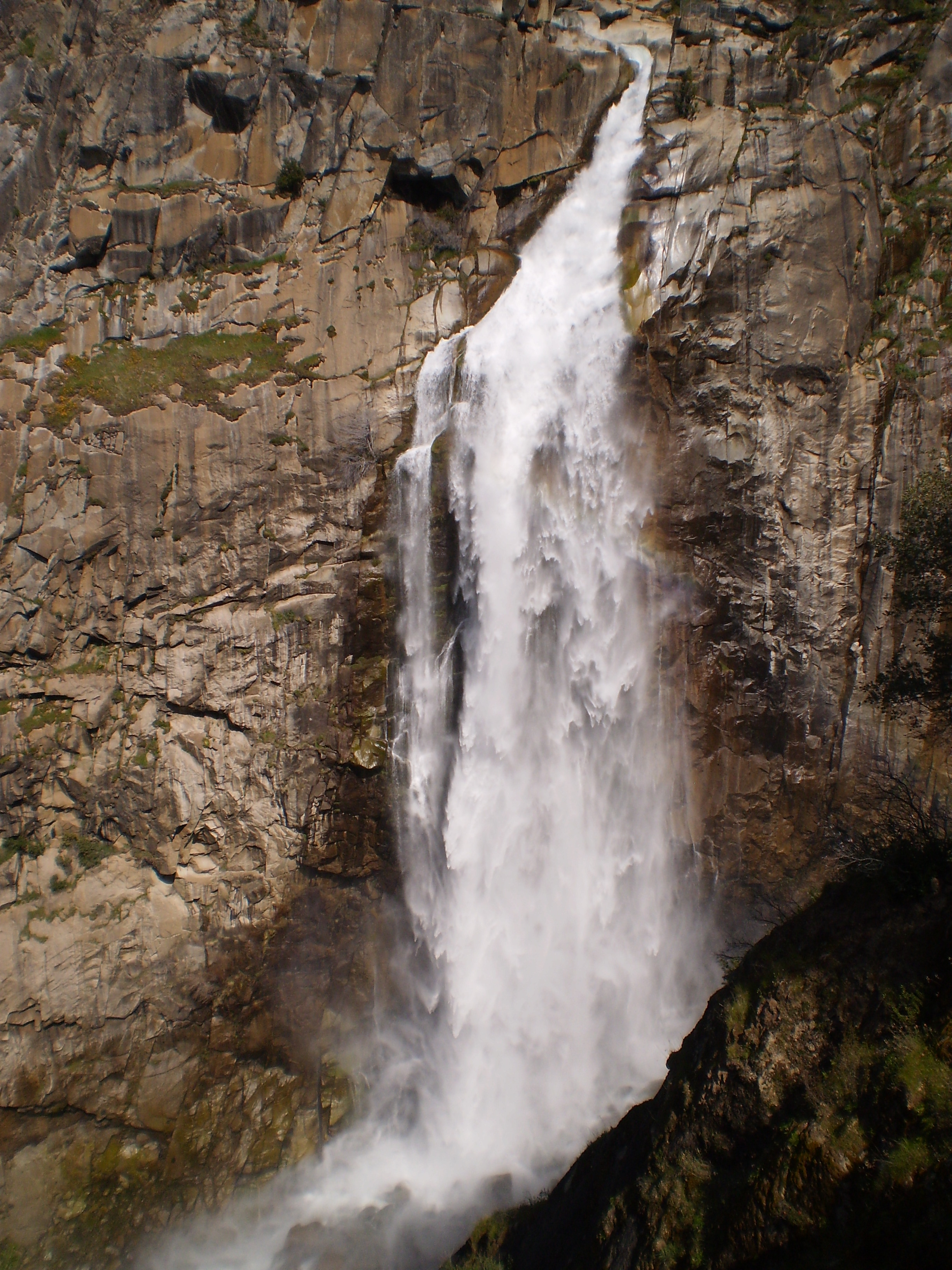
About Feather Falls
Feather Falls (coordinates 39.642973, ‑121.274390) is a single‑drop waterfall perched in the Plumas County landscape of northern California. With a vertical plunge of nearly 125 meters, it ranks among the tallest waterfalls in the state, rivaling the famous Yosemite Falls in sheer height—though it remains far less commercialized.
The falls are fed by the Feather River watershed, which gathers meltwater from the surrounding Sierra slopes. Historically, the area was traversed by the Maidu people, who considered the river and its waterfalls sacred sites for gathering water and seasonal plants. In the early 20th century, logging and mining activity opened up the region, and the name “Feather Falls” was officially recorded as the area became a popular spot for early hikers and naturalists.
Today, Feather Falls is celebrated for its pristine environment and photogenic power. The waterfall’s mist creates a permanent rainbow on sunny days, and the surrounding forest is a haven for wildlife—black‑tailed deer, Steller’s jay, and occasional black bear sightings keep the experience wild and authentic.
How to Get There
By Car
- Start from Redding, CA – The nearest major city (≈ 70 km north) offers easy access via Interstate 5.
- Take Highway 70 east toward Susanville. After about 30 km, turn south onto County Road A13 (also signed “Feather Falls Road”).
- Follow the paved road for roughly 12 km until you reach the Feather Falls Trailhead parking lot. The trailhead sits about 3.2 km from the waterfall itself, marked with a small sign and a pull‑out area for two vehicles.
Pro tip: Cell service is spotty on County Road A13. Download offline maps (Google Maps, Gaia GPS) before you leave.
Public Transportation
Public transit options are limited. The nearest Amtrak station is in Redding, and from there you’ll need a rental car or rideshare to reach the trailhead.
Parking & Fees
Parking at the Feather Falls Trailhead is free, but spaces fill up quickly on weekends during peak season (summer and early fall). Arrive early (7 am–8 am) to secure a spot and enjoy a quieter hike.
Best Time to Visit
| Season | Conditions | Why Visit |
|---|---|---|
| Spring (March‑May) | Snowmelt swells the river; waterfall at peak flow. Trail may be muddy or have lingering snow patches. | Spectacular water volume, vibrant wildflowers, fewer crowds. |
| Summer (June‑August) | Warm, dry weather; trail generally clear. Water flow moderates but still impressive. | Ideal for photography, longer daylight, comfortable hiking temperatures (15‑25 °C). |
| Fall (September‑October) | Cooler temps; foliage begins to turn golden. Water flow still solid from earlier melt. | Stunning autumn colors, crisp air, and the chance to spot migrating birds. |
| Winter (November‑February) | Possible snow on the trail; water may be reduced. Road to trailhead can be icy. | For the adventurous—quiet, icy scenery, and the possibility of frozen mist arches. |
Overall recommendation: Late spring to early fall (April‑October) offers the best combination of water volume, trail safety, and weather comfort.
What to Expect
The Hike
From the Feather Falls Trailhead, the 3.2 km (2 mi) out‑and‑back trek follows a well‑maintained forest path. The trail climbs gently through mixed pine and fir stands, crossing a few small streams via wooden footbridges. Expect a moderate elevation gain of roughly 300 m, which most hikers with basic fitness can handle.
- Scenery: Towering conifers, occasional meadows dotted with lupine, and the distant murmur of the Feather River.
- Wildlife: Keep an eye out for marmots, rattlesnakes (early spring), and the occasional black bear—always store food securely.
The Waterfall
As you near the Feather Falls viewpoint, the sound of rushing water becomes a deep, resonant roar. The cascade drops straight down over a sheer cliff, creating a plume of mist that often forms vivid rainbows when the sun shines from behind. The base of the falls pools into a crystal‑clear basin—perfect for a quick splash (though water can be chilly).
Photographers love the golden hour (just after sunrise or before sunset) when the light highlights the waterfall’s texture and the surrounding forest glows amber. Bring a polarizing filter to reduce glare and enhance the rainbow effect.
Nearby Attractions
After you’ve soaked in the majesty of Feather Falls, extend your adventure with these nearby gems (all within a 12 km radius).
- Feather Falls Trailhead – The starting point of your hike, offering additional short loops and picnic spots.
- Curtain Falls – Just 3.4 km away, this smaller cascade provides a quiet alternative for a quick photo stop.
- Ponderosa Diversion Dam – 10.7 km south, this historic dam showcases early 20th‑century water management and offers a scenic riverside walk.
- Lake Madrone 1004 Dam – 11.5 km east, a tranquil reservoir ideal for fishing, kayaking, or a lakeside picnic.
- Forbestown Diversion Dam – Also 11.5 km away, this spot is popular with birdwatchers looking for waterfowl and raptors.
Each location can be reached via the same County Road A13 network, making a day‑trip loop feasible without returning to the trailhead.
Travel Tips
| Tip | Details |
|---|---|
| Pack layered clothing | Temperatures shift quickly from warm sun to cool forest shade; a light fleece works well. |
| Footwear | Waterproof hiking boots with good traction are essential, especially on spring mud or winter ice. |
| Water & Snacks | No water sources on the trail; bring at least 2 L per person and high‑energy snacks. |
| Leave No Trace | Pack out all trash, stay on the marked path, and avoid disturbing wildlife. |
| Safety | In winter, icy sections can be hazardous; consider microspikes. Carry a basic first‑aid kit and a whistle. |
| Photography | A tripod and neutral‑density filter help capture silky water effects; sunrise shots are magical. |
| Permits | No special permits are required for day hikes, but large groups (>10) should check with Plumas County for any seasonal restrictions. |
| Dog Policy | Dogs are allowed on the trail but must be leashed (max 6 ft) and under control at the waterfall’s edge. |
| Local Services | The nearest grocery and gas station is in Berry Creek (≈ 7 km). Stock up before heading to the trailhead. |
| Emergency | Dial 911 for emergencies; the nearest medical facility is Plumas County Hospital in Portola (≈ 45 km). |
Final Thought
Feather Falls may not have the name recognition of Yosemite, but its towering drop, serene forest setting, and low‑key vibe make it a must‑see waterfall in California for anyone craving authentic wilderness. Whether you’re a seasoned hiker, a nature photographer, or simply a traveler looking for a hidden gem, Feather Falls delivers a memorable experience that feels like a secret shared between you and the Sierra Nevada.
Plan your trip, respect the land, and let the mist of Feather Falls refresh both body and spirit.
For more California waterfall guides and hiking itineraries, subscribe to our newsletter and follow us on Instagram @WanderWestCA.