Deer Creek Falls – A Hidden Waterfall Gem in Chester, California
If you’ve ever chased the sound of rushing water through the pine‑scented forests of Northern California, Deer Creek Falls is the next secret you’ll want to uncover. Nestled in the rugged foothills of Tehama County, this unassuming waterfall offers a peaceful escape from the crowds of more famous destinations. Whether you’re a seasoned hiker, a family looking for a day‑trip adventure, or a photographer hunting that perfect cascade shot, Deer Creek Falls delivers a genuine taste of California’s wild heart.
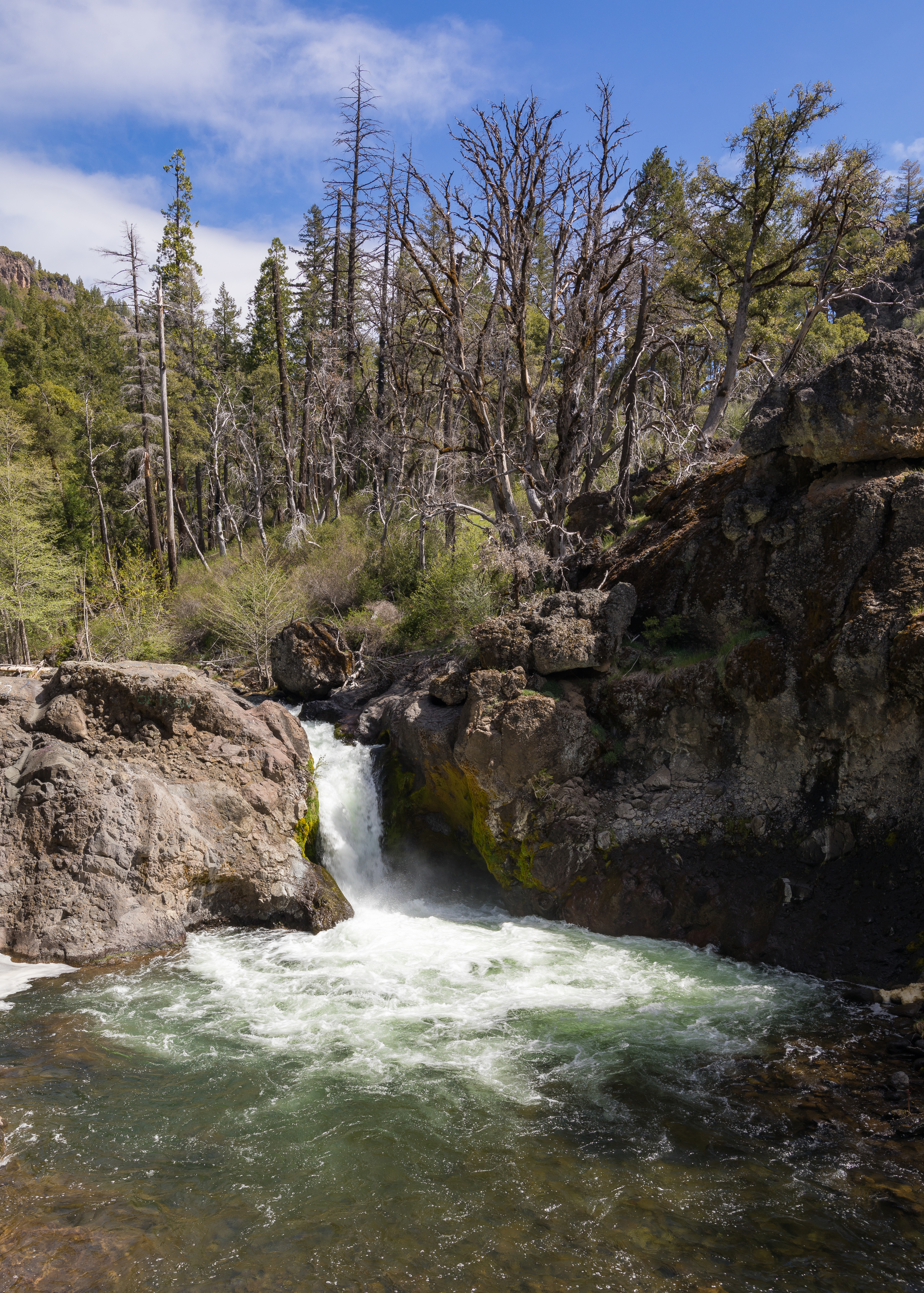
About Deer Creek Falls
Deer Creek Falls is a waterfall located near the small town of Chester, California (coordinates 40.202066, ‑121.513111). The falls are part of Deer Creek, a tributary that winds through the rolling hills and mixed‑conifer forests of Tehama County. While the exact height of the cascade remains undocumented, the waterfall’s charm lies in its natural setting rather than sheer size.
Historically, the Deer Creek watershed has supported local ranching and timber activities, and the surrounding area retains a strong sense of the early‑settlement era. The falls themselves have long been a quiet gathering spot for locals and hikers who know the trail. Because the waterfall isn’t heavily promoted on mainstream tourism platforms, it has stayed relatively untouched—making it an ideal spot for those who crave solitude amid nature.
How to Get There
By Car
- Start in Chester, CA – Chester sits at the junction of Highway 36 and County Road A1. From downtown Chester, head east on Highway 36 toward the small community of Lookout.
- Turn onto Deer Creek Road – After roughly 5 miles, look for a well‑marked Deer Creek Road (a paved county road). This road follows the creek valley and provides the most direct access to the falls.
- Parking – There is a modest pull‑out parking area near the creek bridge (no fees, but it’s first‑come, first‑served). The parking spot is located at the coordinates listed above, so you can use a GPS device or smartphone to pinpoint it.
On Foot
From the parking area, a short, low‑impact trail leads to the waterfall’s viewing platform. The path is unmaintained but generally clear of major obstacles. Expect a gentle uphill walk of 0.5 – 0.7 miles with some rocky sections. Good hiking shoes and a walking stick are recommended, especially after rain when the creek banks can be slick.
Public Transportation
Public transit options are limited in this rural region. The nearest Greyhound stop is in Red Bluff, about 30 miles north. From there, a rental car or rideshare service is the most practical way to reach Deer Creek Falls.
Best Time to Visit
| Season | Conditions | Why Visit |
|---|---|---|
| Spring (March‑May) | Snowmelt and seasonal rains swell Deer Creek, creating a more vigorous flow. Temperatures are mild (50‑70 °F). | The waterfall is at its most dramatic, and wildflowers begin to pepper the forest floor. |
| Summer (June‑August) | Drier conditions; creek flow may lessen but remains steady. Warm days (70‑85 °F) and cooler evenings. | Ideal for picnics and longer hikes in the surrounding hills. Less crowd pressure. |
| Fall (September‑November) | Light rains can revive the creek. Autumn colors start to appear in the mixed‑conifer canopy. | Photographers love the golden light and the contrast of amber foliage with the water. |
| Winter (December‑February) | Possible snow on higher elevations; creek may be at its fullest, but trail can be icy. | For the adventurous, winter offers a raw, powerful waterfall experience—just bring traction devices. |
Overall recommendation: Late spring to early fall provides the most reliable access and a balanced water flow, making it the sweet spot for most visitors.
What to Expect
Arriving at Deer Creek Falls, you’ll first hear the gentle roar of water before you see it—a subtle reminder that nature is already at work. The cascade tumbles over a series of smooth rock ledges, creating a series of mini‑pools that reflect the surrounding pine canopy. Because the height isn’t officially recorded, the falls feel intimate—perfect for stepping close enough to feel the mist on your face.
The surrounding forest is a mix of ponderosa pine, Douglas fir, and incense‑cedar, offering a fragrant backdrop. Birdsong is abundant; keep an eye out for Steller’s jay, Western tanager, and the occasional red‑tailed hawk circling above. The trail’s natural footing means you’ll likely encounter small creek crossings and occasional fallen logs—part of the authentic wilderness feel.
For photographers, the best light arrives mid‑morning when the sun filters through the canopy, illuminating the water’s surface. In the golden hour (just before sunset), the falls take on a warm glow, and the surrounding hills cast long, dramatic shadows—perfect for landscape shots.
Nearby Attractions
While Deer Creek Falls can easily fill a half‑day adventure, the surrounding area offers several complementary natural sites:
- Little Cub Spring – A crystal‑clear spring just 6.2 km away. Ideal for a quick dip or a quiet meditation spot.
- Lower Deer Creek Falls – Located 6.9 km downstream, this secondary cascade offers a different perspective of the Deer Creek watershed.
- Tamarack Spring – Approximately 9.8 km away, this spring is surrounded by tamarack trees, providing a serene forest oasis.
These sites can be combined into a full‑day loop or visited on separate days for a deeper exploration of Tehama County’s hidden waterways.
Travel Tips
| Tip | Details |
|---|---|
| Pack water and snacks | The area has limited facilities; bring enough supplies for at least 4 hours. |
| Leave no trace | Use existing trails, pack out all trash, and avoid disturbing wildlife. |
| Check road conditions | County Road A1 can be icy in winter or washed out after heavy rain. Call the Tehama County road department if unsure. |
| Bring a waterproof camera case | Mist from the falls can dampen equipment quickly. |
| Wear layered clothing | Temperatures fluctuate dramatically from creek level to ridge tops. |
| Safety first | The creek can be deceptively swift after rain; stay behind the safety rail (if present) and avoid climbing on wet rocks. |
| Mobile signal | Expect spotty coverage; download offline maps beforehand. |
| Pet policy | Dogs are allowed on leash (max 6 ft). Keep them away from the water’s edge to prevent accidents. |
| Seasonal closures | In heavy snow years, the trail may be closed for safety. Verify with the Tehama County Parks & Recreation office before heading out. |
Final Thoughts
Deer Creek Falls may not have the towering fame of Yosemite’s Yosemite Falls, but its quiet charm, accessible location, and surrounding natural beauty make it a standout destination for anyone traveling through Northern California. By timing your visit right, respecting the environment, and exploring the nearby springs and lower falls, you’ll experience a slice of California’s wilderness that feels both timeless and personal.
Pack your boots, charge your camera, and let the gentle roar of Deer Creek guide you to an unforgettable adventure. Happy trails!
