Burney Falls – The “Everlasting” Waterfall of Northern California
“If you ever stand beneath the mist of Burney Falls, you’ll understand why it’s called the “Everlasting” waterfall.”
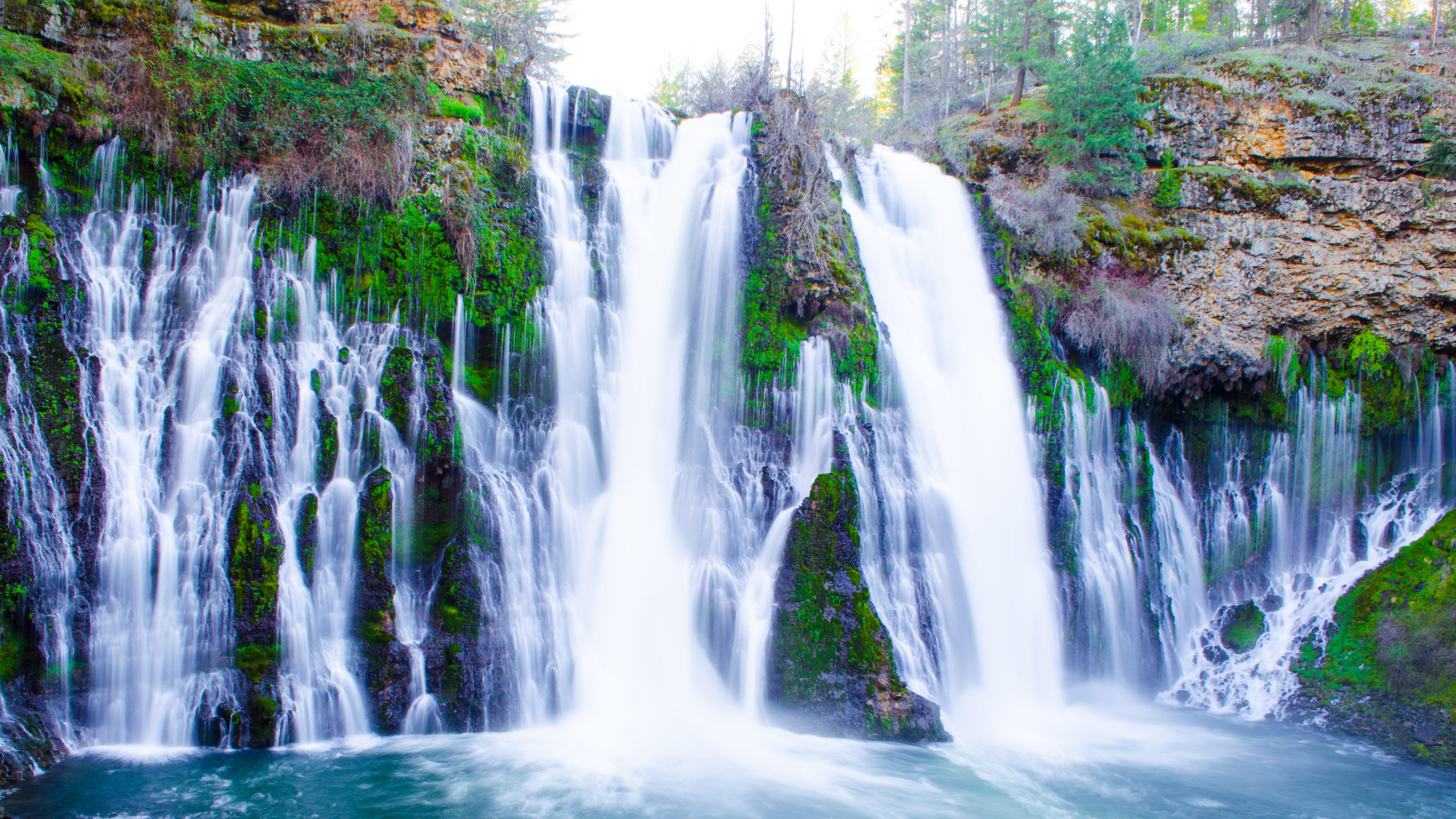
Nestled in the rugged heart of Shasta County, Burney Falls is a 35‑meter (115‑foot) cascade that seems to pour straight from the sky. With its crystal‑clear waters, towering pine forests, and a backdrop of volcanic peaks, this waterfall is a magnet for hikers, photographers, and anyone craving a slice of untouched wilderness. Whether you’re planning a day trip from Sacramento, a weekend getaway from the Bay Area, or a stop on a larger Northern California road trip, Burney Falls deserves a top spot on your itinerary.
About Burney Falls
Burney Falls sits on the Upper Sacramento River just outside the small town of Burney, California (coordinates 41.011947, ‑121.651965). The falls drop a dramatic 35 meters into a turquoise plunge pool, creating a thunderous roar that can be heard from several hundred meters away.
History & Significance
The falls were first documented by early settlers in the mid‑1800s, but it wasn’t until the early 20th century that they gained national attention. In 1926, the Burney family—who owned the surrounding land—donated a 1,400‑acre parcel to the state, establishing McArthur‑Burney Falls Memorial State Park. The park was named for John McArthur, a local conservationist who championed the protection of the falls.
Because the water flow is fed by Lake Britton and numerous underground springs, Burney Falls maintains a steady volume year‑round, earning it the nickname “Everlasting.” The waterfall has also been featured in several Hollywood movies, including “The Lost World: Jurassic Park” and “The Revenant,” cementing its status as a cinematic icon.
How to Get There
By Car
- From Redding: Take CA‑299 East for about 45 miles. Turn left onto CA‑89 South and follow the signs to McArthur‑Burney Falls Memorial State Park. The park entrance is just a few minutes after the small town of Burney.
- From Sacramento: Drive north on I‑5 to Redding, then follow the route above. The total drive is roughly 3 hours (≈ 250 miles).
GPS Navigation
Enter the coordinates 41.011947, -121.651965 into your GPS or smartphone map app for a direct route to the park’s main parking lot.
Public Transportation
While there is limited public transit in this remote region, Amtrak’s California Zephyr stops in nearby Redding. From there, you can rent a car or arrange a rideshare to reach Burney Falls.
Parking & Accessibility
The park offers a spacious main parking lot (approximately 200 spaces) with a short, paved trail leading to the falls. The trail is wheelchair‑accessible up to the viewing platform, though the final steps down to the riverbank are stairs.
Best Time to Visit
| Season | Highlights | Visitor Tips |
|---|---|---|
| Spring (Mar‑May) | Snowmelt boosts water flow; wildflowers bloom along the trail. | Arrive early; crowds start to increase by late May. |
| Summer (Jun‑Aug) | Warm, dry weather perfect for picnics and swimming in the plunge pool. | Bring sun protection; afternoon thunderstorms are possible. |
| Fall (Sep‑Nov) | Brilliant foliage, especially in October; water flow remains strong. | Ideal for photography; weekday visits are less crowded. |
| Winter (Dec‑Feb) | Misty atmosphere; lower visitor numbers. | Dress in layers; some trail sections may be icy. |
Overall recommendation: Late spring to early fall (April‑October) offers the most reliable water flow and pleasant hiking conditions. If you love vibrant colors and fewer crowds, aim for mid‑October.
What to Expect
The Sights & Sounds
As you approach the falls, the roar of water grows louder, mingling with the scent of pine and fresh earth. The main viewing platform provides a panoramic vista of the cascade, allowing you to capture the full 35‑meter drop as it plunges into a sapphire pool. From the platform, you can also glimpse the rainbow that often arches across the mist on sunny days.
Trails & Activities
- Falls Trail (0.5 mi, easy): A paved loop that circles the falls, with interpretive signs about the geology and native wildlife.
- River Trail (2 mi, moderate): Follows the Upper Sacramento River upstream, offering quieter spots for birdwatching and occasional trout sightings.
- Picnic Areas: Several shaded tables and grills sit near the riverbank—perfect for a family lunch.
Wildlife
Expect to see black-tailed deer, bobcats, and a variety of songbirds. The river is home to rainbow trout, making it a popular spot for fly‑fishing (permit required).
Nearby Attractions
While Burney Falls can easily fill a full day, the surrounding area offers additional natural wonders and historic sites that complement your visit.
| Attraction | Type | Distance from Burney Falls | Quick Info |
|---|---|---|---|
| Pit Number Three Dam | Dam | 2.2 km | A historic hydro‑electric dam with scenic overlooks. |
| Clark Creek Falls | Waterfall | 3.2 km | A smaller cascade tucked in a secluded canyon—great for a quick hike. |
| Rock Creek Falls | Waterfall | 5.4 km | Offers a rugged trail and a refreshing plunge pool. |
| [Unnamed Weir] | Weir | 6.9 km | Ideal for anglers looking for a quiet spot. |
| [Unnamed Spring] | Spring | 7.0 km | A natural spring feeding the local watershed—perfect for nature lovers. |
Tip: All of these attractions are reachable via short drives on well‑maintained county roads. Pack a day‑trip snack and a map, and you’ll have a mini‑adventure circuit that showcases the diversity of Shasta County’s water features.
Travel Tips
- Arrive Early – The main parking lot fills up quickly during peak summer weekends. Getting there by 9 am guarantees a spot and a quieter viewing experience.
- Dress in Layers – Even in summer, the mist from the falls can feel cool, especially near the riverbank. A lightweight rain jacket is a smart addition.
- Stay Hydrated – There are water fountains at the visitor center, but bring a reusable bottle for the hike.
- Leave No Trace – Pack out all trash, stay on marked trails, and respect wildlife. The park’s pristine condition depends on responsible visitors.
- Photography Hacks – Use a polarizing filter to reduce glare on the water and capture vivid rainbows. Early morning light (golden hour) provides the softest shadows.
- Permits & Fees – Entrance to McArthur‑Burney Falls Memorial State Park costs $8 per vehicle (2024 rate). If you plan to fish, obtain a California fishing license and a park fishing permit.
- Safety First – The rocks around the plunge pool are slippery. Keep a safe distance from the edge, especially with children.
- Seasonal Closures – In heavy winter storms, the River Trail may be temporarily closed due to icy conditions. Check the park’s website or call ahead for real‑time updates.
Final Word
Burney Falls is more than just a waterfall; it’s a living tableau of Northern California’s natural heritage. From the thunderous cascade that never ceases to the tranquil forest paths that wind around it, the site offers a perfect blend of adventure and serenity. Pair it with nearby gems like Pit Number Three Dam or Clark Creek Falls, and you’ve got a full‑day itinerary that showcases the region’s rugged beauty.
So pack your hiking boots, charge your camera, and head north to experience the everlasting magic of Burney Falls—a waterfall that truly lives up to its legend.
Happy travels!