Barker Dam – A Hidden Gem in the Heart of Joshua Tree National Park
Coordinates: 34.030891, ‑116.146331 | Twentynine Palms, California, USA
Introduction
If you’ve ever dreamed of stepping into a living postcard—where rugged desert cliffs frame a tranquil pool of water, ancient rock art whispers stories of the past, and the scent of creosote fills the air—Barker Dam is the place to make that dream a reality. Nestled just a few miles north of Twentynine Palms, this historic dam is one of Joshua Tree National Park’s most photographed landmarks, offering a perfect blend of natural beauty, cultural heritage, and easy‑going adventure. Whether you’re a seasoned hiker, a family on a road‑trip, or a photographer hunting that golden‑hour glow, Barker Dam should sit at the top of your California desert itinerary.
About Barker Dam
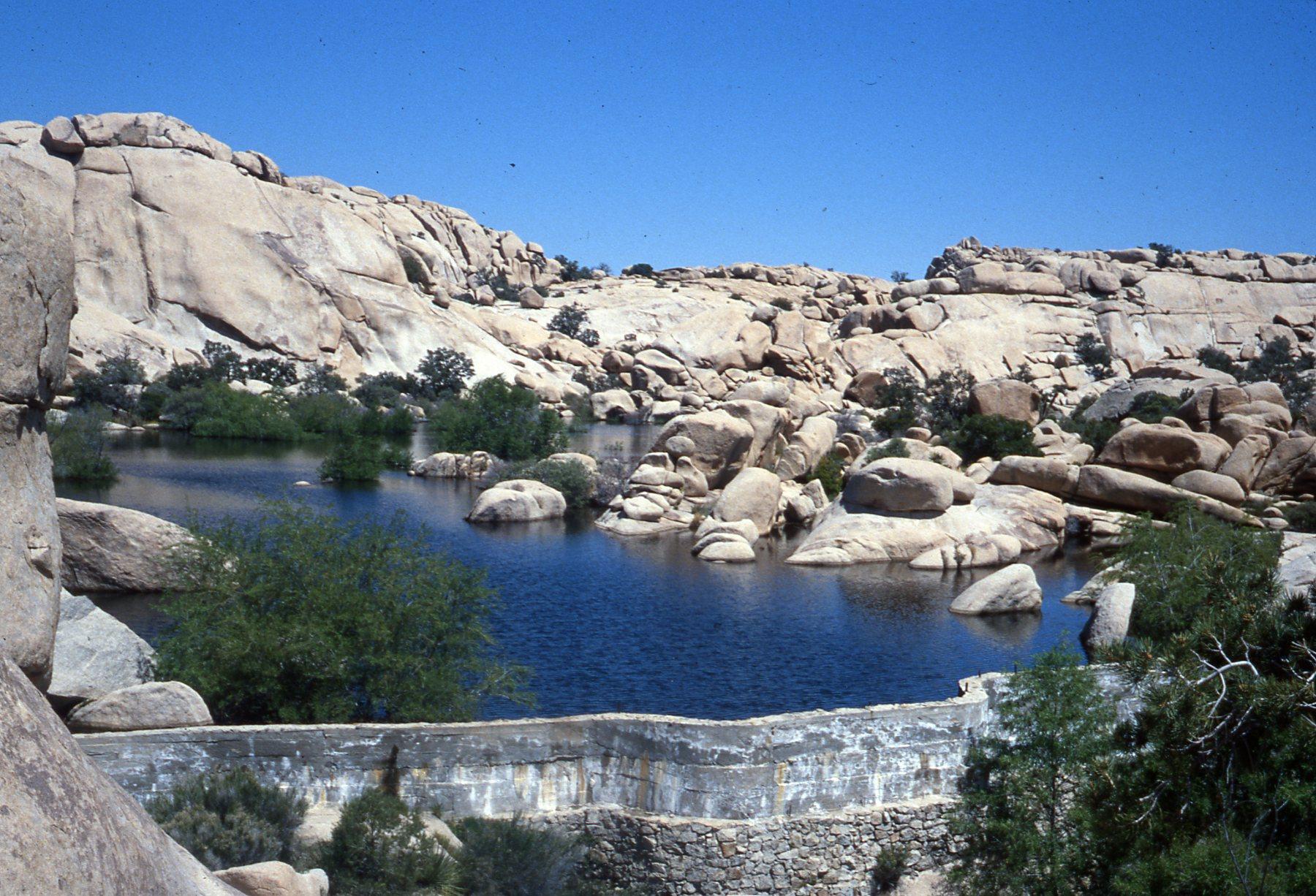
Built in the early 1900s by early ranchers seeking a reliable water source, Barker Dam has evolved from a practical irrigation structure into a historic landmark within Joshua Tree National Park. The dam’s original purpose was to capture runoff from the surrounding mountains to sustain livestock and small farms. In the 1930s, the Civilian Conservation Corps (CCC) reinforced the dam and added a small concrete spillway, giving it the sturdy, rustic look you see today.
Although the exact height and altitude of the dam remain undocumented, its presence is unmistakable. The reservoir behind the stone‑lined wall creates a shimmering oasis that attracts desert wildlife—rabbits, lizards, and a surprising variety of birds—making it a prime spot for wildlife watching and photography. Moreover, the area around Barker Dam is dotted with petroglyphs etched by Native American peoples centuries ago, adding a layer of cultural significance that deepens the visitor experience.
Designated on the National Register of Historic Places, Barker Dam is not just a functional structure; it’s a living museum that tells the story of human perseverance in the harsh Mojave Desert. Its easy‑access trail, historic interpretation signs, and scenic vistas have turned it into a must‑see destination for anyone exploring the park’s iconic landscapes.
How to Get There
By Car
-
From Los Angeles: Take I‑10 East toward Palm Springs. Exit onto CA‑62 (Twentynine Palms Highway) and follow it for about 30 mi. Turn left onto Park Boulevard (the main entrance road for Joshua Tree National Park). Follow the signs to the Barker Dam Trailhead—the parking lot is just a short walk from the trailhead.
-
From San Diego: Head north on I‑15, then merge onto CA‑62 eastbound at the junction near Yucca Valley. The same directions apply from there.
-
From Twentynine Palms: Drive north on CA‑62 for roughly 3 mi, then turn right onto Park Road. The Barker Dam parking area is clearly marked and offers a small, free lot (arrive early during peak season as spaces fill quickly).
Public Transportation
While public transit options are limited in the desert, the Riverside Transit Agency (RTA) runs a limited service from the Twentynine Palms Amtrak station to the park entrance during summer weekends. Check the RTA website for the latest schedule and plan to rent a bike or join a guided tour for the final stretch to the dam.
Parking & Accessibility
- Parking: Free, but limited to ~30 vehicles. Arrive early in the morning (especially on weekends) to secure a spot.
- Accessibility: The Barker Dam Trail is a moderately flat, 1.3‑mile loop with a well‑maintained surface, making it wheelchair‑friendly for most of the route. However, some sections near the water’s edge can be uneven, so use caution if you have mobility concerns.
Best Time to Visit
| Season | Weather | Why Visit |
|---|---|---|
| Fall (Oct‑Nov) | Daytime highs 70‑80 °F, cool evenings | Ideal for comfortable hiking and spectacular sunset photography. |
| Winter (Dec‑Feb) | Daytime 50‑65 °F, occasional rain | Fewer crowds; the reservoir may hold more water, attracting more birds. |
| Spring (Mar‑May) | Daytime 70‑85 °F, desert wildflowers blooming | Perfect for nature lovers; the trail is lush with blooming desert flora. |
| Summer (Jun‑Sep) | Daytime 95‑110 °F, intense sun | Not recommended for hiking; if you must, go early morning or late afternoon and bring ample water. |
Pro tip: Arriving early (around sunrise) not only helps you beat the heat but also gives you the best light for photography and a chance to spot wildlife before the crowds arrive.
What to Expect
The Trail Experience
The Barker Dam Trail is a 1.3‑mile loop that winds through Joshua tree groves, rocky outcrops, and the historic dam itself. The path is well‑marked with interpretive signs that explain the dam’s construction, the role of the CCC, and the significance of the nearby petroglyphs. Expect a gentle elevation change—most visitors describe the hike as “easy to moderate,” suitable for families and casual walkers.
Scenic Highlights
- The Dam & Reservoir: The stone wall and its tranquil pool make a perfect backdrop for photos. In early spring, the water can be deep enough for reflections of the surrounding cliffs.
- Petroglyphs: Near the dam’s north side, you’ll find shallow carvings depicting animal tracks, geometric patterns, and human figures. While touching the rock is discouraged to preserve these ancient artworks, they offer a tangible connection to the region’s Indigenous heritage.
- Wildlife: Keep an eye out for Mojave desert tortoises, coyote tracks, and a variety of bird species such as the American kestrel, cactus wren, and greater roadrunner. Early morning is the best time for birdwatching.
Amenities
- Restrooms: Portable toilets are available at the trailhead.
- Water: No drinking water is provided; bring at least 1 liter per person, more in hot weather.
- Picnic Area: A small shaded bench near the parking lot offers a spot for a quick snack.
Nearby Attractions
While Barker Dam is a highlight on its own, the surrounding area boasts several other natural and historic sites worth exploring:
| Attraction | Distance | Type | Quick Link |
|---|---|---|---|
| Cow Camp Dam | 1.6 km (≈1 mi) | Dam | Cow Camp Dam (Wikipedia) |
| Johnson Spring | 6.2 km (≈3.9 mi) | Spring | Johnson Spring (Google Maps) |
| Sneakeye Spring | 6.9 km (≈4.3 mi) | Spring | Sneakeye Spring (Google Maps) |
| (Unnamed Dam) | 2.6 km (≈1.6 mi) | Dam | (link unavailable – explore on the park map) |
These sites can be reached via short, unpaved park roads or by extending your hike onto the Backcountry Loop (check with the park ranger station for current trail conditions). Each offers a quieter, off‑the‑beaten‑path experience that complements the main Barker Dam visit.
Travel Tips
- Arrive Early – Parking fills up fast, especially on weekends and holidays. Getting there before 9 am guarantees a spot and cooler temperatures.
- Pack Sun Protection – The desert sun is intense year‑round. Bring a wide‑brimmed hat, sunscreen (SPF 30+), and UV‑blocking sunglasses.
- Stay Hydrated – Even in cooler months, the dry air can dehydrate you quickly. Carry a reusable water bottle and consider a hydration pack for longer hikes.
- Leave No Trace – Pack out all trash, stay on designated trails, and avoid touching the petroglyphs to preserve this cultural treasure.
- Check Park Alerts – Before you head out, visit the Joshua Tree National Park website for any trail closures, fire restrictions, or weather advisories.
- Photography Gear – A wide‑angle lens captures the expansive desert vistas, while a telephoto lens helps isolate wildlife. Sunrise and sunset provide the most dramatic lighting.
- Guided Tours – If you’re interested in deeper historical context, consider joining a ranger‑led walk (usually offered on weekends).
Wrap‑Up
Barker Dam may be modest in size, but its blend of history, scenery, and accessibility makes it a standout destination for anyone traveling through Southern California’s desert heart. From the moment you step onto the trail, you’ll be immersed in a landscape that feels both timeless and alive—where a century‑old dam still holds water, ancient petroglyphs whisper stories, and the desert blooms with life in every season.
So lace up your boots, charge your camera, and set your GPS to 34.030891, ‑116.146331. Barker Dam awaits, ready to add a splash of adventure to your California road trip. Happy travels!