Coolidge Dam, Arizona – A Hidden Gem for Water‑Loving Travelers
Coordinates: 33.174648, ‑110.527790 | Height: 76.2 m | Altitude: 722 m
Introduction
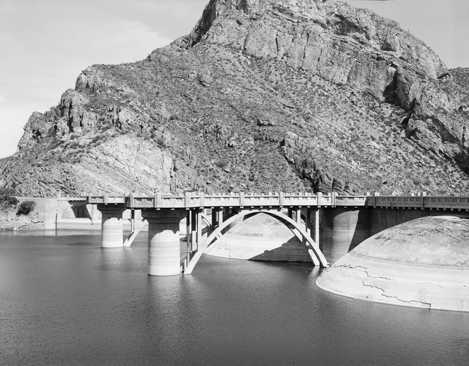
If you’ve ever craved a road‑trip that blends engineering marvels, desert scenery, and peaceful water‑side picnics, Coolidge Dam in Peridot, Arizona should be at the top of your itinerary. Nestled in the heart of the Sonoran Desert, this 250‑foot concrete arch dam offers more than just a striking silhouette against the sky—it’s a gateway to quiet springs, native wildlife, and a slice of Arizona history that most visitors miss. Whether you’re a photography enthusiast, a family on a weekend getaway, or a history buff, Coolidge Dam delivers a surprisingly rich experience in just a few hours of driving.
About Coolidge Dam
Built between 1928 and 1930, Coolidge Dam was named after President Calvin Coolidge, who championed water‑resource projects in the Southwest. The dam is a concrete arch structure standing 76.2 meters (250 ft) tall, perched at an elevation of 722 meters (2,370 ft) above sea level. Its primary purpose is to store water for the San Carlos Apache Indian Reservation, creating the San Carlos Reservoir that stretches over 4,000 acres.
Why the Dam Matters
- Water Security – The reservoir supplies irrigation and municipal water to a largely arid region, making it a lifeline for local communities.
- Engineering Heritage – As one of the early 20th‑century arch dams in the United States, it showcases the ingenuity of engineers who tackled the challenges of desert hydrology.
- Recreational Hub – While the dam itself isn’t open for tours, the surrounding area offers fishing, bird‑watching, and scenic overlooks that attract outdoor lovers year‑round.
For a deeper dive into the dam’s history, check out the Coolidge Dam Wikipedia page.
How to Get There
By Car
The most convenient way to reach Coolidge Dam is by driving from Tucson International Airport (TUS) or the city of Tucson itself:
- Head east on I‑10 toward the town of Sahuarita (≈ 30 mi).
- Take exit 260 for AZ‑77 North toward Peridot.
- Follow AZ‑77 for roughly 15 mi; you’ll see signs for Coolidge Dam just before you enter the Peridot area.
The total drive from Tucson is about 80 mi (130 km) and takes 1 hour 30 minutes under normal traffic conditions.
From Phoenix
If you’re coming from Phoenix, hop on I‑10 East toward Tucson, then follow the same AZ‑77 route. The trip is roughly 180 mi (290 km) and takes ≈ 3 hours.
Public Transportation
Arizona’s Greyhound service stops in nearby Safford, but you’ll still need a rental car or rideshare to cover the final 30‑mile stretch. For most travelers, renting a compact SUV is the easiest option, especially if you plan to explore the surrounding springs.
Parking
A small, free parking lot sits at the dam’s overlook. Spaces fill up quickly on sunny weekends, so arrive early (before 10 am) to secure a spot.
Best Time to Visit
| Season | Weather | Why Visit |
|---|---|---|
| Winter (Dec‑Feb) | Mild days (55‑70 °F) & cool nights | Fewer crowds, crisp desert light perfect for photography |
| Spring (Mar‑May) | Warm days (70‑85 °F) & blooming desert flora | Ideal for bird‑watching and nearby spring hikes |
| Summer (Jun‑Aug) | Hot (90‑105 °F) | Early morning visits are refreshing; reservoir water is perfect for a quick dip |
| Fall (Sep‑Nov) | Comfortable temps (70‑80 °F) | Golden hour lighting over the dam; harvest festivals in nearby towns |
Tip: The dam’s concrete surface can reflect intense sunlight in midsummer, so bring a hat and sunscreen if you’re visiting between June and August.
What to Expect
Scenic Overlook
A short, paved walkway leads to a panoramic viewpoint where the dam’s arch curves dramatically against the horizon. The reservoir’s turquoise water contrasts beautifully with the surrounding red‑rock mesas, offering endless photo opportunities.
Quiet Picnic Areas
Scattered benches and picnic tables line the shoreline. Bring a cooler—fishing enthusiasts often spot largemouth bass, catfish, and rainbow trout in the cooler months.
Wildlife & Birdwatching
Early mornings reveal great blue herons, sandhill cranes, and occasional bald eagles soaring overhead. The desert scrub hosts cactus wren, gila monsters, and a variety of desert wildflowers after seasonal rains.
Limited Facilities
There are no restrooms or concession stands on site, so plan ahead. The nearest services are in Peridot (≈ 5 mi) or Safford (≈ 30 mi).
Safety
The dam’s spillway is off‑limits to the public. Stay behind marked barriers and respect posted signs. The water can be deceptively cold, especially in early spring.
Nearby Attractions
Exploring the area around Coolidge Dam adds depth to your desert adventure. All the spots below are within a 7‑km radius, making them perfect for a day‑trip itinerary.
| Attraction | Distance from Dam | What to See | Link |
|---|---|---|---|
| Soda Spring | 3.7 km | A natural spring with crystal‑clear water; great for a short hike and a refreshing sip. | Soda Spring |
| Kidde Spring | 3.8 km | Secluded oasis surrounded by desert shrubs; ideal for birdwatching. | Kidde Spring |
| Anderson Spring | 4.3 km | Small waterfall feeding a shallow pool; perfect for family photos. | Anderson Spring |
| Wild Horse Spring | 6.0 km | Named for historic sightings of wild mustangs; offers a rugged trail for hikers. | Wild Horse Spring |
| Evans Spring | 6.3 km | A quiet spring with a shaded picnic area; great for a relaxed lunch. | Evans Spring |
Note: Some spring pages may be limited; a quick Google search will provide additional details and trail maps.
Travel Tips
- Pack Plenty of Water – The desert climate can dehydrate you quickly, especially if you plan to hike to the nearby springs.
- Arrive Early – Parking fills up fast on weekends; an early start also gives you the best lighting for photos.
- Check Reservoir Levels – Water levels fluctuate seasonally; low levels can expose more of the dam’s structure, while high levels may limit shoreline access.
- Bring a Binocular Set – Birdwatchers will appreciate a good pair for spotting raptors and waterfowl.
- Respect Native Lands – The dam supplies water to the San Carlos Apache Reservation. Stay on marked roads and follow any cultural guidelines posted.
- Leave No Trace – Carry out all trash, especially near the springs where delicate ecosystems thrive.
- Mobile Connectivity – Service can be spotty; download offline maps of the area before you leave.
- Seasonal Road Conditions – Winter rains can make desert washouts; check the Arizona Department of Transportation (ADOT) website for any road closures before heading out.
Ready to Experience Coolidge Dam?
From its historic concrete arch to the tranquil springs that pepper the landscape, Coolidge Dam offers a unique blend of engineering, nature, and quiet desert charm. Pack your camera, fill up the water bottles, and set your GPS to 33.174648, ‑110.527790. Whether you’re chasing sunrise over the reservoir or exploring the hidden springs nearby, this off‑the‑beaten‑path destination will add a memorable chapter to your Arizona travel story. Safe travels!