Kirazlık Barajı – A Hidden Water Wonder in Siirt, Turkey
Discover the serene beauty of Kirazlık Dam, an off‑the‑beaten‑path destination that blends nature, engineering, and local culture in the heart of southeastern Turkey.
1. Introduction
If you’ve already trekked the turquoise lagoons of Pamukkale or the dramatic cliffs of Cappadocia, it’s time to turn your compass toward the quiet province of Siirt. Nestled near the historic town of Tillo, Kirazlık Barajı (Kirazlık Dam) may not appear on the typical tourist map, but its tranquil reservoir, sweeping valley views, and authentic village atmosphere make it a perfect spot for travelers seeking peace, photography, and a glimpse of Turkey’s modern water infrastructure.
Whether you’re a road‑trip enthusiast, a nature‑lover, or a curious engineer, Kirazlık Dam offers a unique backdrop for sunrise picnics, bird‑watching, and quiet contemplation—far from the crowds of Turkey’s coastal hotspots.
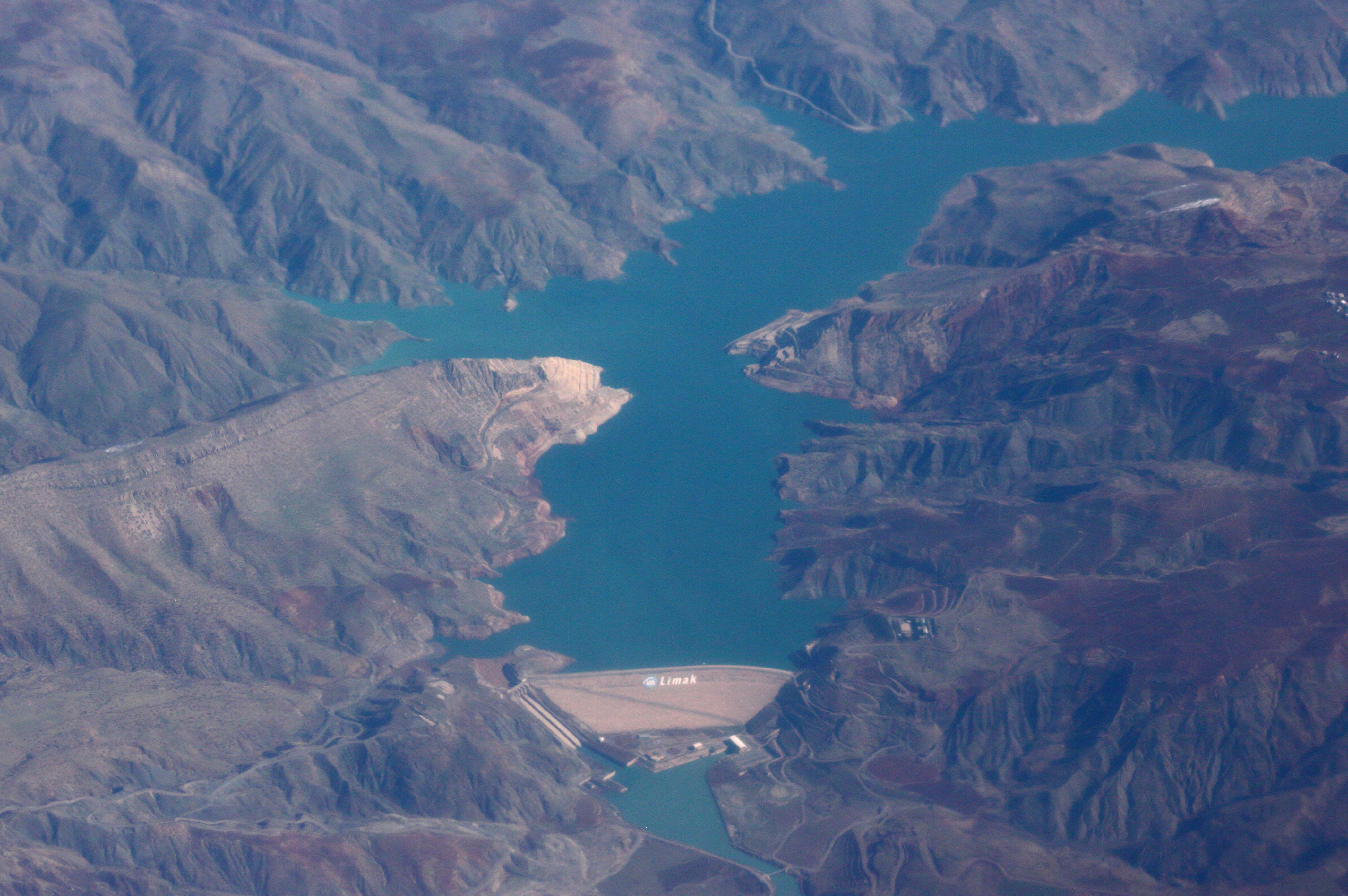
2. About Kirazlık Barajı
What Is Kirazlık Barajı?
Kirazlık Barajı is a dam located in the district of Tillo, within Siirt Province, Turkey. Its precise coordinates are 37.923201 N, 42.061338 E, placing it in a rugged, semi‑arid landscape that transitions between the Mesopotamian plains and the foothills of the Taurus Mountains.
While official sources list the dam’s height and altitude as “unknown,” the structure plays a vital role in local water management, supporting irrigation, livestock watering, and modest hydro‑electric generation for nearby villages. The reservoir created by the dam is surrounded by rolling hills dotted with olive groves, apricot orchards, and traditional stone houses, offering a snapshot of rural life in southeastern Turkey.
A Brief History
Kirazlık Dam was constructed as part of Turkey’s nationwide effort to improve water resources in the 20th and 21st centuries. Although exact dates are scarce, the dam’s development aligns with the government’s broader initiatives to boost agricultural productivity and secure water supply in the Siirt region, which historically faced seasonal droughts.
The name “Kirazlık” translates roughly to “place of cherries,” hinting at the once‑abundant cherry orchards that grew along the riverbanks before the reservoir was formed. Today, the dam’s presence has reshaped the local ecosystem, creating new habitats for waterfowl and fish, while still preserving the cultural imprint of the surrounding villages.
Why It Matters
- Water Security – Kirazlık Barajı helps regulate river flow, ensuring that farms downstream receive a steady water supply during dry months.
- Eco‑Tourism Potential – The calm waters attract migratory birds and provide a scenic setting for low‑impact activities such as kayaking, fishing, and photography.
- Cultural Connection – Visiting the dam offers insight into Turkey’s rural development story and the everyday lives of Siirt’s residents.
3. How to Get There
By Air
The nearest major airport is Şanlıurfa GAP Airport (GNY), about 210 km (≈ 130 mi) west of Kirazlık Barajı. From the airport, you can rent a car or catch a regional bus to Siirt city center (≈ 150 km).
If you prefer a shorter flight, Diyarbakır Airport (DIY) is another option, roughly 180 km away. Both airports have regular domestic connections from Istanbul, Ankara, and İzmir.
By Bus & Shared Taxi
- Siirt City Bus Terminal – Daily intercity buses run from major Turkish hubs (Istanbul, Ankara, Istanbul) to Siirt.
- Local Minibusses (Dolmuş) – From Siirt’s central station, look for minibusses heading toward Tillo. The ride to Tillo takes about 45 minutes and costs a few Turkish Lira.
By Car
Driving gives you the most flexibility to explore the surrounding countryside:
- From Siirt – Take the D.965 highway east toward Tillo. After about 30 km, follow the signposts for “Kirazlık Barajı.”
- From Şanlıurfa – Head north on the D.400, then turn east onto D.965. The total drive is roughly 3 hours.
Road conditions are generally good, but be prepared for occasional gravel sections near the dam. A GPS or offline map app (e.g., Maps.me) will be handy, as cell coverage can be spotty in the valley.
Parking & Access
A modest parking lot sits at the dam’s main access road, offering space for cars, motorbikes, and small vans. From there, a short, well‑marked trail leads down to the water’s edge.
4. Best Time to Visit
| Season | Weather | Why Visit |
|---|---|---|
| Spring (March‑May) | Mild temperatures (15‑22 °C), occasional rain | Wildflowers bloom on the hillsides; bird migration peaks—great for photography. |
| Summer (June‑August) | Warm to hot (28‑35 °C), dry | Ideal for swimming, kayaking, and picnics; evenings are pleasantly cool. |
| Autumn (September‑November) | Comfortable (18‑25 °C), golden foliage | Harvest festivals in nearby villages; lower tourist traffic. |
| Winter (December‑February) | Cool (5‑12 °C), occasional snow on surrounding hills | Quiet atmosphere; perfect for reflective walks, though water levels may be lower. |
Top recommendation: Aim for late April to early June when the reservoir is full, the surrounding vegetation is lush, and the weather is comfortably warm without the peak summer heat.
5. What to Expect
Scenic Views
Approach the dam and you’ll be greeted by a broad, glass‑like surface that mirrors the sky and the rugged hills beyond. The reservoir stretches for several kilometers, framed by olive groves and low stone walls that hint at centuries‑old agricultural practices.
Activities
- Photography – Sunrise over the water creates striking pastel tones; the dam’s concrete silhouette against the mountains is a favorite shot for landscape photographers.
- Bird‑Watching – Look for species such as the Eurasian hoopoe, white‑eyed gull, and various waders that stop over during migration.
- Kayaking & Paddle‑boarding – Small rental operators in Tillo offer inflatable kayaks for a modest fee.
- Picnic & Relaxation – Bring a blanket, some local cheese (beyaz peynir), olives, and fresh bread for a lakeside lunch.
Amenities
Facilities are basic but sufficient: a small kiosk sells bottled water, tea, and light snacks. Restrooms are available near the parking area, though they are simple pit‑toilets—plan accordingly.
Cultural Touch
If you time your visit with a local market day in Tillo (usually Thursday), you’ll witness villagers trading fresh produce, handmade textiles, and traditional sweets. The friendly locals often invite travelers to share a cup of çay (Turkish tea) and a story about the dam’s impact on their lives.
6. Nearby Attractions
Kirazlık Barajı sits in a region dotted with other water‑related sites and natural gems. Consider adding one (or more) of the following to your itinerary:
| Attraction | Type | Distance from Kirazlık Barajı | Quick Link |
|---|---|---|---|
| Alkumru Barajı | Dam | 4.8 km | Alkumru Dam (Wikipedia) |
| Kaynak Suyu | Spring | 15.9 km | — |
| Şirvan Barajı | Dam | 16.0 km | — |
| Unnamed Weir | Weir | 24.3 km | — |
| Çetin Barajı | Dam | 28.3 km | — |
Tip: The short drive between Kirazlık and Alkumru Barajı makes a perfect half‑day loop, allowing you to compare two modern Turkish dams set against contrasting backdrops.
7. Travel Tips
| Tip | Details |
|---|---|
| Carry Cash | Small villages often accept only Turkish Lira, and many shops don’t have card terminals. |
| Dress Modestly | Rural Turkey leans toward conservative attire—especially when visiting villages or mosques. Light, breathable layers are ideal. |
| Stay Hydrated | Even in cooler months, the semi‑arid climate can be dehydrating. Bring a reusable water bottle. |
| Respect the Environment | Pack out all trash, stay on marked paths, and avoid disturbing wildlife, especially during nesting season. |
| Language | Turkish is the primary language; a few basic phrases (“Merhaba,” “Teşekkür ederim,” “Su var mı?”) go a long way. |
| Safety | The dam’s water can be cold; wear water shoes if you plan to wade. Check local weather forecasts—sudden thunderstorms can arise in summer. |
| Connectivity | Mobile coverage improves near Tillo, but you may experience dead zones at the dam itself. Download offline maps and any needed guides before you arrive. |
| Timing | Arrive early (around sunrise) to beat any occasional crowds and capture the best light for photos. |
Final Thought
Kirazlık Barajı may not have the fame of Turkey’s iconic landmarks, but its quiet charm, striking scenery, and authentic local vibe make it a rewarding destination for the adventurous traveler. By exploring this hidden dam, you’ll not only add a unique photo to your travel album but also gain a deeper appreciation for the ways modern engineering and timeless rural traditions coexist in the heart of Siirt. Pack your camera, hit the road, and let the gentle ripple of Kirazlık’s waters welcome you to a side of Turkey that few tourists ever see.
Happy travels!