Çetin Barajı – The Majestic Dam Hidden in Siirt’s Rugged Landscape
If you think Turkey’s tourism is all about turquoise coasts and bustling bazaars, think again. Deep in the southeastern province of Siirt, the towering silhouette of Çetin Barajı (Çetin Dam) rises 165 meters above the river, offering a dramatic blend of engineering marvel and untouched nature. Whether you’re a road‑trip enthusiast, a photography junkie, or a traveler hunting off‑the‑beaten‑path gems, Çetin Barajı deserves a spot on your itinerary.
1. Introduction
Imagine standing on a quiet hilltop, the wind whispering through pine‑scented air, and below you a crystal‑blue reservoir glistening against the backdrop of sheer cliffs. That’s Çetin Barajı—Turkey’s newest high‑rise dam, completed in the 2010s, and one of the tallest structures in the region at 165 m. While the dam itself is a feat of modern engineering, the surrounding landscape is a tapestry of rolling hills, traditional villages, and rugged mountain passes that feel worlds away from Istanbul’s traffic jams.
Travelers who venture to Çetin Barajı often describe it as a “secret oasis” where you can soak up spectacular views, learn about Turkey’s water‑resource strategies, and explore nearby attractions that showcase the cultural richness of Siirt and neighboring Bitlis. Ready to add this hidden treasure to your travel bucket list? Let’s dive in.
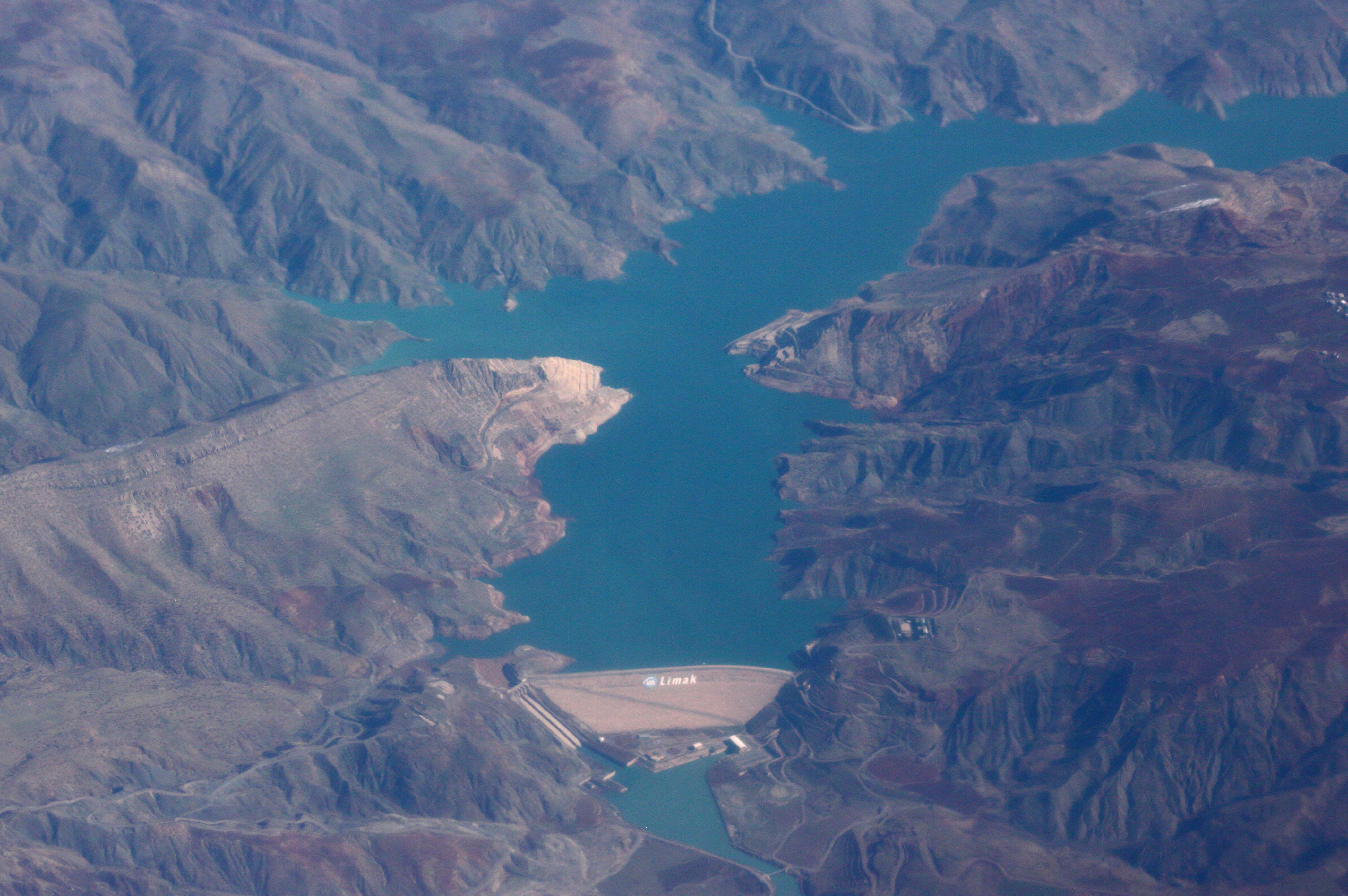
2. About Çetin Barajı
A Brief History
Çetin Barajı, officially known as Çetin Dam, is situated near the village of Gökçekoru in Siirt Province. Construction began in the early 2010s as part of Turkey’s broader initiative to increase renewable energy capacity and improve irrigation for the semi‑arid southeastern plateau. The dam was completed in 2017 and quickly became one of the country’s tallest concrete‑face rock‑fill dams, standing 165 m tall.
Why It Matters
- Hydropower Production – The dam contributes a modest but vital amount of electricity to the regional grid, supporting local industries and households.
- Water Management – By regulating the flow of the river, Çetin Barajı helps mitigate seasonal flooding and ensures a steady water supply for agriculture in Siirt’s valleys.
- Tourism Potential – Its impressive height, striking design, and surrounding natural scenery have turned the dam into an emerging spot for eco‑tourism and photography.
Even though the exact altitude of the dam site is not publicly listed, its elevated position offers panoramic vistas that rival any famous dam in the world. For a deeper dive into the technical side, you can check the official Wikipedia entry: Çetin Dam.
3. How to Get There
By Air
The nearest airport is Siirt Airport (SXZ), located roughly 45 km north of Gökçekoru. The airport handles domestic flights from major hubs such as Istanbul and Ankara. From the terminal, you can rent a car or arrange a taxi to the dam (the drive takes about 1 hour).
By Bus
Intercity buses from Siirt city center run regularly to the town of Gökçekoru. The journey is about 30 km and takes roughly 45 minutes. Ask the driver to drop you off at the main road junction leading to the dam; a short walk or a quick local‑taxi ride will get you to the viewing area.
By Car
If you prefer self‑drive, follow these simple directions:
- From Siirt: Take the D.965 highway heading southeast toward Gökçekoru.
- Turn onto the local road marked “Çetin Barajı” (signage is modest but visible).
- Follow the signs for the dam’s parking lot—there is a small, free lot near the visitor platform.
The route is scenic, winding through pine forests and open pastures, and the road is well‑maintained year‑round. GPS coordinates for the exact location are 37.974258, 42.376837.
Public Transport Tip
Buses in the region run less frequently on weekends, so plan your arrival on a weekday if you want more flexibility. Also, keep a small amount of Turkish Lira handy for any on‑the‑spot tickets or refreshments.
4. Best Time to Visit
| Season | Weather | Why Visit |
|---|---|---|
| Spring (April‑June) | Mild temperatures (15‑22 °C), blooming wildflowers | Ideal for photography, comfortable hiking |
| Summer (July‑August) | Warm to hot (25‑35 °C), clear skies | Best for sunrise/sunset shots over the reservoir |
| Autumn (September‑October) | Cool evenings, golden foliage | Perfect for relaxed walks and bird‑watching |
| Winter (November‑March) | Cold, occasional snow | The dam’s silhouette against a snowy backdrop is stunning, but some access roads may be icy |
Top recommendation: Visit during late spring (mid‑May to early June) when the water level is high, the surrounding hills are lush, and the temperature is pleasant for outdoor activities.
5. What to Expect
The Visual Experience
- Imposing Height: At 165 m, the dam’s concrete face towers above the water, creating a dramatic vertical line that dominates the horizon.
- Crystal‑Clear Reservoir: The impounded water reflects the sky like a mirror, especially during sunrise and sunset, offering photographers endless golden‑hour opportunities.
- Panoramic Views: From the designated viewing platform, you can see the rugged Siirt plateau stretching out to the distant peaks of the Taurus Mountains.
Activities
- Photography: Capture the dam’s engineering lines, the ripple of water, and the surrounding flora.
- Short Hikes: There are marked trails that loop around the reservoir, suitable for casual walkers.
- Picnicking: A few shaded benches and picnic tables are available near the parking lot—bring a snack and enjoy the serene atmosphere.
Facilities
- Restrooms: Basic facilities are available near the visitor area.
- Information Board: A small kiosk provides details about the dam’s construction, capacity, and environmental impact (in Turkish and English).
- No Admission Fee: Access to the viewing area is free, though some guided tours may charge a modest fee.
Because the dam is an active infrastructure site, certain areas are restricted for safety reasons. Respect any “No Entry” signs and stay on marked paths.
6. Nearby Attractions
While Çetin Barajı is the star of the show, the surrounding region offers several other points of interest that can easily be added to a day‑trip itinerary. All distances are measured from the dam’s visitor area.
| Attraction | Type | Distance | Location | Quick Note |
|---|---|---|---|---|
| [Weir (Unnamed)] | Weir | 23.1 km | Siirt, Turkey | Small water‑control structure ideal for a quick stop and local photo ops. |
| [Unnamed Dam] | Dam | 23.9 km | Bitlis, Turkey | A modest dam that showcases Bitlis’ water management efforts. |
| Alkumru Barajı | Dam | 25.1 km | Siirt, Turkey | Known for its serene reservoir and surrounding pine forests. |
| [Unnamed Dam] | Dam | 25.2 km | Bitlis, Turkey | Another functional dam offering insight into regional hydro‑engineering. |
| Kirazlık Barajı | Dam | 28.3 km | Siirt, Turkey | A quieter spot perfect for bird‑watchers and quiet contemplation. |
Pro tip: Combine Çetin Barajı with a visit to Alkumru Barajı for a “Dam Trail” that lets you compare two of Siirt’s most impressive water projects in a single day.
7. Travel Tips
| Tip | Details |
|---|---|
| Dress in Layers | Even in summer, mornings can be cool near the water; bring a light jacket. |
| Sun Protection | The open plateau offers little shade; pack sunscreen, a hat, and sunglasses. |
| Hydration | Carry at least 1 L of water per person, especially if you plan to hike. |
| Local Currency | Small vendors accept cash only; ATMs are available in Siirt city. |
| Language | Turkish is the primary language; a few basic phrases (e.g., “Merhaba,” “Teşekkür ederim”) go a long way. |
| Respect the Site | As an operational dam, stay on marked paths and obey safety signs. |
| Photography Gear | A wide‑angle lens works wonders for capturing the dam’s height; a tripod helps with sunrise/sunset shots. |
| Timing | Arrive early (around 8 am) to beat any small crowds and enjoy softer light. |
| Connectivity | Mobile signal can be spotty; download offline maps beforehand. |
| Nearby Food | Try local Siirt cuisine—especially İçli Köfte (stuffed meatballs) and Badem Tatlısı (almond dessert)—in Gökçekoru or Siirt town. |
Final Thoughts
Çetin Barajı may not yet be on every traveler’s radar, but its blend of engineering grandeur, natural beauty, and tranquil surroundings makes it a standout destination for the adventurous soul. From the awe‑inspiring 165‑meter concrete wall to the gentle ripple of the reservoir, the dam offers a rare glimpse into Turkey’s modern infrastructure set against an ancient landscape. Pair it with nearby dams, local villages, and the warm hospitality of Siirt’s people, and you’ll leave with memories—and photos—that stand as tall as the dam itself.
Pack your camera, hit the road, and let Çetin Barajı become the highlight of your southeastern Turkey adventure. Safe travels!