Diga della Val Malvaglia – A Hidden Gem in Ticino, Switzerland
Explore the striking 92‑metre‑high dam, soak in Alpine scenery, and discover nearby waterfalls and historic sites—all in one unforgettable day.
Introduction
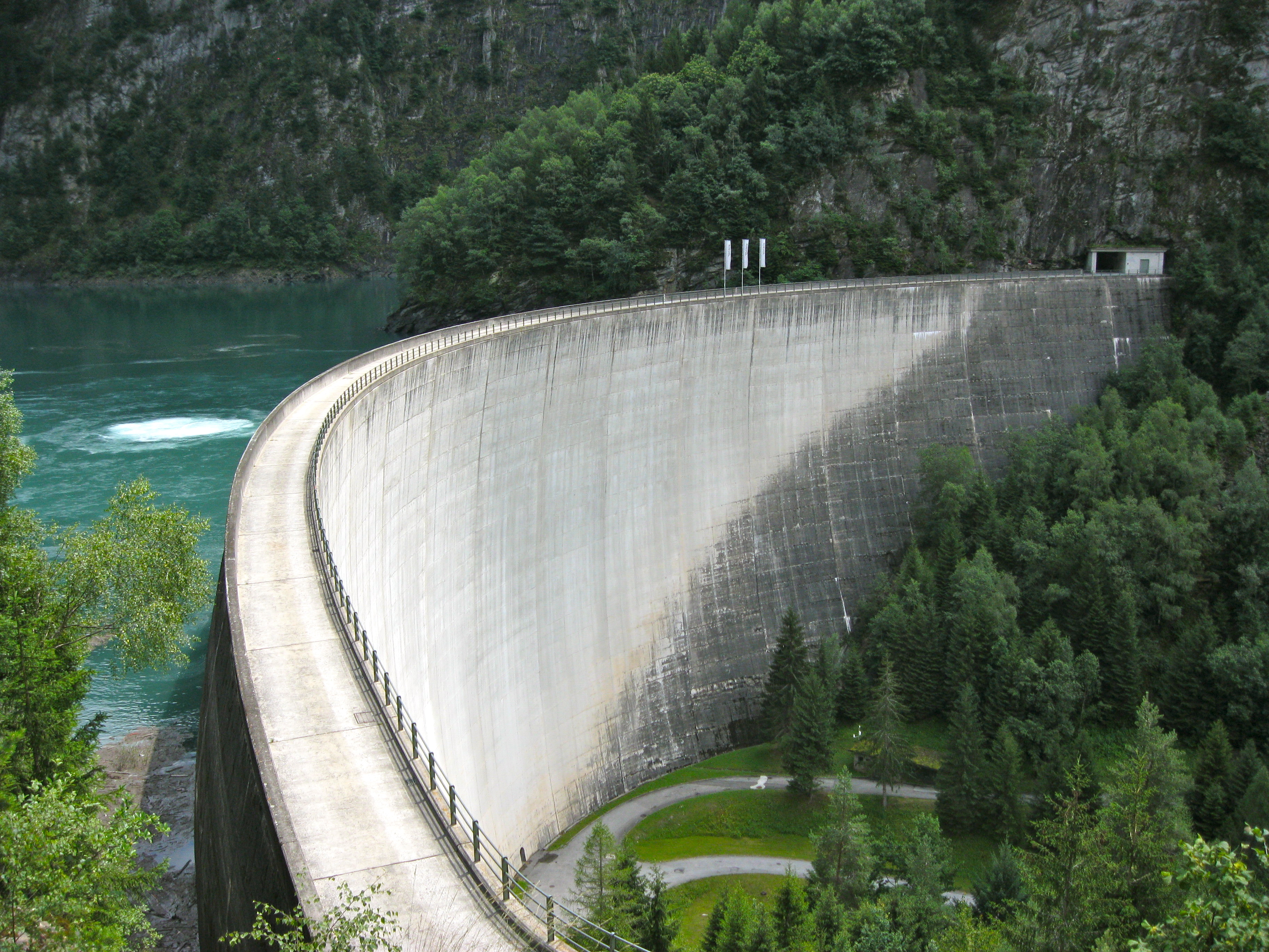
Tucked away in the lush valleys of Ticino, the Diga della Val Malvaglia (Val Malvaglia Dam) may not appear on the typical Swiss travel itinerary, but it should. This impressive 92‑metre concrete structure dominates the landscape at coordinates 46.423900 N, 9.021016 E, offering a perfect blend of engineering marvel, natural beauty, and tranquil outdoor adventure. Whether you’re a photography enthusiast, a civil‑engineering buff, or simply a traveler hunting off‑the‑beaten‑path sights, the dam and its surrounding area deliver a rewarding experience that feels both grand and intimate.
About Diga della Val Malvaglia
A Brief Description
The Diga della Val Malvaglia is a gravity dam built to regulate water flow in the valley of Malvaglia, a small municipality in the canton of Ticino. Standing 92 meters tall, the dam creates a serene reservoir that reflects the surrounding peaks, pine forests, and the iconic Swiss sky. Its sleek concrete façade contrasts beautifully with the rugged Alpine terrain, making it a favorite subject for landscape photographers.
History & Significance
Constructed in the mid‑20th century (exact year not listed in public sources), the dam was part of a broader effort to harness the hydropower potential of the Ticino region. While its primary purpose is water management and energy generation, the structure also plays a vital role in flood control for downstream communities.
From an engineering perspective, the dam exemplifies the Swiss commitment to precision and sustainability. Its design integrates seamlessly with the environment, minimizing visual impact while delivering reliable performance. The reservoir also supports local biodiversity, providing habitats for fish and waterfowl.
Why It Matters to Travelers
- Scenic Views: The dam’s elevation offers panoramic vistas of the Val Malvaglia and the surrounding Lepontine Alps.
- Photography Opportunities: Early morning mist over the water, golden‑hour lighting on the concrete, and dramatic mountain backdrops make for striking images.
- Educational Value: Visitors can appreciate the blend of natural forces and human ingenuity that powers much of Switzerland’s clean energy.
How to Get There
By Car
The most straightforward way to reach the dam is by car. From Bellinzona (the capital of Ticino), follow the A2 motorway north toward Biasca, then take the SS40 road that leads directly to Malvaglia. The drive takes roughly 45 minutes and offers scenic Alpine passes along the way. Parking is available near the dam’s visitor area (look for signage indicating “Parcheggio Diga Val Malvaglia”).
By Public Transport
If you prefer public transport, the regional bus network connects Bellinzona and Biasca to Malvaglia.
- Train: Take a Swiss Federal Railways (SBB) train from Bellinzona to Biasca (about 15 minutes).
- Bus: From Biasca, hop on the PostBus line that runs toward Malvaglia; the journey lasts roughly 30 minutes.
- Walking: The dam is a short, well‑marked walk from the Malvaglia village center—follow the local signs pointing to “Diga”.
By Bike or Hiking
For the adventurous, the valley’s network of mountain bike trails and hiking paths leads to the dam. The route from Malvaglia village is moderate in difficulty (≈ 2 km, gentle ascent) and perfect for a sunrise or sunset trek.
Best Time to Visit
| Season | Highlights | Visitor Tips |
|---|---|---|
| Spring (April‑June) | Snowmelt fills the reservoir, waterfalls swell, wildflowers bloom along the valley floor. | Bring waterproof shoes; the trail can be muddy. |
| Summer (July‑September) | Long daylight hours, warm weather, perfect for picnics by the water. | Arrive early to avoid midday crowds and enjoy cooler temperatures. |
| Autumn (October‑November) | Golden foliage frames the dam; crisp air enhances panoramic views. | Dress in layers; evenings get chilly. |
| Winter (December‑March) | The dam is often dusted with snow, creating a dramatic, quiet landscape. | Check road conditions; some access roads may be closed after heavy snowfall. |
Overall recommendation: Late spring (mid‑May to early June) and early autumn (late September) provide the best combination of pleasant weather, vivid scenery, and fewer tourists.
What to Expect
The Visitor Experience
- Scenic Overlook: A designated viewing platform sits just a few meters from the dam’s crest, offering unobstructed sightlines across the reservoir and into the valley.
- Interpretive Panels: Informational boards explain the dam’s construction, its role in hydropower, and local flora/fauna.
- Quiet Picnic Areas: Benches and tables are scattered near the water’s edge—ideal for a relaxed lunch while listening to the gentle lapping of the reservoir.
- Photography Spots: The best angles are found at the western side (sunrise) and eastern side (sunset). Bring a wide‑angle lens to capture the full scale of the structure against the mountains.
Safety & Accessibility
- The site is open year‑round, but some paths may be slippery after rain.
- The main viewing platform is wheelchair‑accessible, though the surrounding trails are uneven.
- No official guided tours are offered, but local volunteers occasionally provide informal talks during the summer months.
Nearby Attractions
The Val Malvaglia region is dotted with natural wonders that complement a dam visit. Below are the top spots within a short drive (distances are approximate):
- Waterfall – 2.9 km – A cascading waterfall hidden in a forested gorge. Perfect for a short hike and a splash of mist on your camera lens.
- Waterfall – 3.0 km – Another picturesque fall, known for its crystal‑clear pool at the base—ideal for a quick dip in summer.
- Weir – 3.5 km – An historic weir that once regulated water flow for local mills; now a quiet spot for birdwatching.
- Waterfall – 4.2 km – A larger, multi‑tiered waterfall that creates a natural amphitheater of sound.
- Dam – 5.9 km – A neighboring dam offering a comparative look at different engineering styles within the same valley.
For more details on each site, search the specific name on the Ticino tourism portal or consult the local visitor centre in Malvaglia.
Travel Tips
- Check the Weather: Alpine weather can change rapidly. A quick glance at MeteoSwiss before heading out will help you pack appropriate gear.
- Bring a Reusable Water Bottle: The reservoir water is pristine, and many picnic areas have refill stations.
- Stay Connected: Mobile coverage is generally good in Malvaglia, but signal may drop near the dam. Download offline maps (e.g., SwissTopo app) just in case.
- Respect the Environment: Stick to marked paths, carry out any litter, and avoid feeding wildlife. The area is a protected habitat for several bird species.
- Timing for Photography: Early morning (sunrise) and late afternoon (golden hour) provide the most dramatic lighting on the concrete structure and surrounding peaks.
- Local Cuisine: After your visit, stop at a nearby ristorante in Malvaglia for Ticinese specialties such as polenta and merlot wine.
- Currency & Payments: Switzerland uses the Swiss franc (CHF). Most establishments accept credit cards, but it’s handy to have some cash for small vendors.
Bottom Line
The Diga della Val Malvaglia may be a functional piece of infrastructure, but it also serves as a captivating destination for travelers seeking authentic Swiss Alpine experiences. From its towering 92‑meter height and tranquil reservoir to the surrounding waterfalls and historic weirs, the site offers a perfect blend of natural beauty, engineering intrigue, and outdoor recreation. Pack your camera, hop on a regional bus or drive the scenic route, and discover why this hidden dam is quickly becoming a favorite among discerning explorers of Ticino.
Happy travels, and may your visit to Diga della Val Malvaglia be as unforgettable as the landscape itself!