Diga del Sambuco – The Majestic 130‑Metre Dam Hidden in Ticino’s Alpine Heart
If you think Switzerland is only about chocolate, watches, and snow‑capped peaks, think again. Tucked away near the village of Airolo in the canton of Ticino, the Diga del Sambuco (Sambuco Dam) stands as a striking blend of engineering prowess and alpine scenery. Whether you’re a road‑trip enthusiast, a lover of industrial heritage, or simply chasing breathtaking vistas, this dam deserves a spot on your Swiss itinerary.
1. Introduction
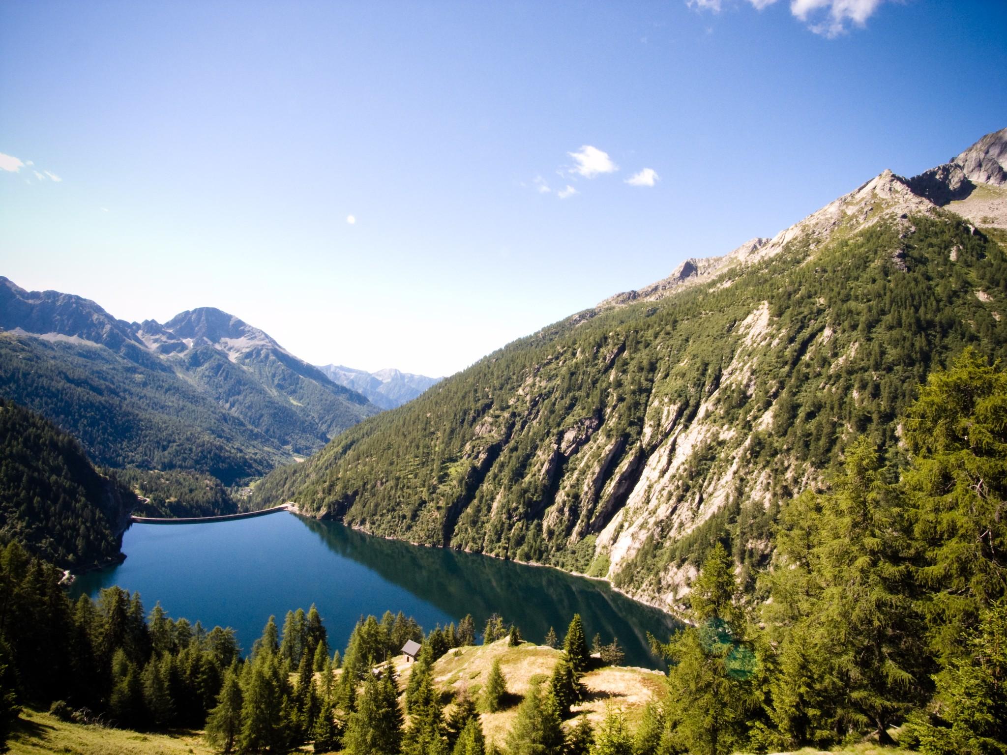
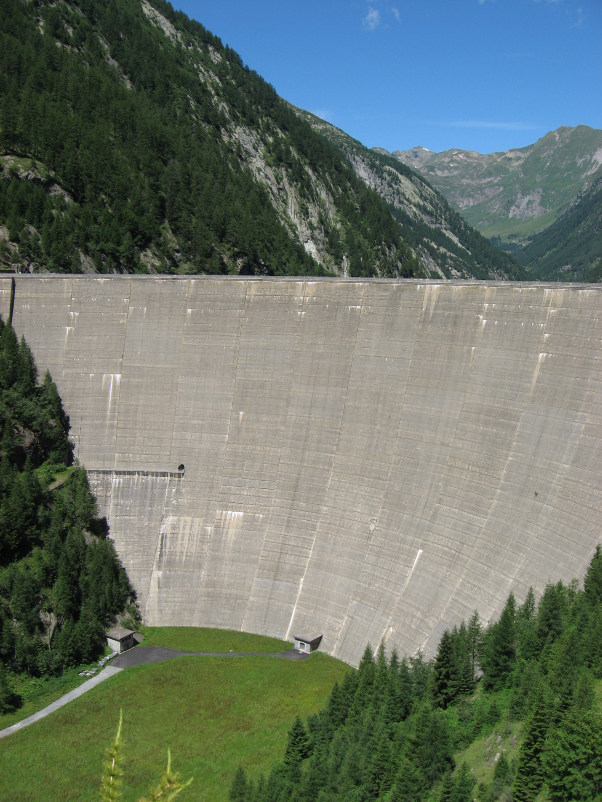
Imagine driving through the crisp mountain air of the Swiss Alps, the road winding past pine‑clad ridges, and suddenly a colossal concrete wall rises from a turquoise lake – 130 metres tall, its sheer face reflecting the sky. That’s the first impression of Diga del Sambuco, a hydro‑electric dam that not only powers the region but also offers an unforgettable backdrop for photographers, hikers, and curious travelers alike.
Located at 46.455594 N, 8.660061 E in the municipality of Airolo, the dam is a hidden gem in Ticino, the Italian‑speaking canton that borders Italy. While the dam itself is a functional piece of infrastructure, the surrounding landscape – dotted with waterfalls, a historic weir, and alpine trails – turns a simple stopover into a full‑day adventure.
2. About Diga del Sambuco
Description & Technical Highlights
- Type: Concrete gravity dam 🏗️
- Height: 130 metres (≈ 426 ft)
- Location: Airolo, Ticino, Switzerland
- Coordinates: 46.455594 N, 8.660061 E
The dam creates the Sambuco Reservoir, a deep, blue‑green lake that mirrors the surrounding peaks. Although the exact altitude of the dam isn’t publicly listed, its position high in the Alps guarantees dramatic elevation changes and stunning panoramas.
Historical Context
The Diga del Sambuco was constructed as part of Switzerland’s extensive hydro‑electric network, which supplies a substantial portion of the nation’s clean energy. While detailed historical dates are scarce in public sources, the dam’s design reflects mid‑20th‑century engineering trends: massive concrete structures built to harness the power of alpine rivers while blending into the rugged terrain.
Significance
- Energy Production: The dam contributes to the regional power grid, supporting both local communities and the broader Swiss demand for renewable electricity.
- Tourism Magnet: Its impressive scale and the serene reservoir attract hikers, cyclists, and photographers.
- Environmental Stewardship: As a hydro‑electric facility, it exemplifies Switzerland’s commitment to low‑carbon energy sources.
For a concise overview, check the Italian Wikipedia entry: Diga del Sambuco.
3. How to Get There
By Train
- Airolo Railway Station sits on the historic Gotthard Railway line, connecting Zurich, Milan, and the rest of Switzerland.
- From the station, the dam is a short taxi ride (≈ 5 km) or a pleasant 30‑minute walk along well‑marked mountain paths.
By Car
- A2 Motorway (Zurich – Chiasso) runs directly through the Gotthard Tunnel and exits near Airolo.
- Follow signs for “Diga del Sambuco / Lago di Sambuco”. Parking is available at the reservoir’s visitor area (small lot, fill up early in peak season).
By Bus / Shuttle
- Local bus line PostAuto 1 links Airolo town centre with the dam area during the summer months (check the latest timetable).
Practical Tips
- Road Conditions: In winter, snow chains may be required; the road can be closed during heavy snowfall.
- Navigation: Input the coordinates 46.455594, 8.660061 into your GPS for pinpoint accuracy.
4. Best Time to Visit
| Season | Weather & Landscape | Visitor Experience |
|---|---|---|
| Spring (April‑June) | Snow melt feeds the reservoir, waterfalls are at peak flow. Temperatures range 8‑15 °C. | Ideal for photography; fewer crowds. |
| Summer (July‑September) | Warm days (15‑25 °C), clear skies, full hiking season. | Best for picnics by the lake, boat rentals (if available), and longer trail excursions. |
| Autumn (October‑November) | Golden foliage contrasts with the dam’s concrete. Cooler temps (5‑12 °C). | Perfect for tranquil walks and capturing sunrise over the water. |
| Winter (December‑March) | Snow‑covered scenery, occasional ice on the reservoir. | Limited access; only for adventurous winter hikers with proper gear. |
Recommendation: Aim for late May to early October for the most reliable weather, vibrant scenery, and full access to nearby attractions.
5. What to Expect
Visual Impact
Approaching the dam, the first thing you’ll notice is its sheer verticality – a solid wall of concrete that seems to rise from the water itself. The reservoir’s surface often glistens like a mirror, reflecting the surrounding peaks of the Lepontine Alps.
Sensory Experience
- Sounds: The gentle rush of the Sambuco River, occasional splashes from the waterfalls nearby, and the low hum of turbines (if the visitor centre offers a glimpse of the power plant).
- Smells: Fresh alpine air mixed with pine and, in summer, a faint scent of wildflowers.
Activities
- Scenic Walks: A short trail circles the reservoir, offering multiple viewpoints of the dam and the lake.
- Photography: Capture sunrise behind the dam, long‑exposure shots of the water, or wide‑angle panoramas of the Alpine backdrop.
- Picnic Spots: Designated benches near the water’s edge are perfect for a lunch break.
- Educational Insight: If you’re interested in hydro‑electric technology, the nearby visitor information board explains the dam’s operation and its role in Swiss energy production.
6. Nearby Attractions
While the Diga del Sambuco is the star, the surrounding area hosts several natural wonders within a short radius:
| Distance | Attraction | What to See | Approx. Link |
|---|---|---|---|
| 0 km | Diga del Sambuco (Dam) | The dam itself, reservoir views | — |
| 0.4 km | Waterfall | A cascading waterfall feeding the reservoir; perfect for a quick photo stop. | — |
| 3.9 km | Weir | Historic water‑control structure; illustrates traditional Alpine water management. | — |
| 5.9 km | Waterfall | Larger waterfall set in a forested gorge; ideal for a short hike. | — |
| 6.0 km | Waterfall | Another scenic cascade, often less crowded, offering tranquil ambience. | — |
Tip: Combine these spots into a circular hike that starts at the dam, loops past the 0.4 km waterfall, continues to the weir, and returns via the 5.9 km and 6.0 km waterfalls. Bring sturdy walking shoes and a water bottle.
7. Travel Tips
| Tip | Details |
|---|---|
| Start Early | Parking fills up quickly in summer; arriving before 9 am secures a spot and gives you daylight for the full hike. |
| Dress in Layers | Alpine weather changes rapidly; a breathable base layer, insulated mid‑layer, and waterproof outer layer work best. |
| Carry Cash | Some small kiosks or parking meters near the dam accept only cash. |
| Respect the Environment | Stay on marked trails, pack out all litter, and avoid swimming in the reservoir (water is used for power generation). |
| Check Opening Times | While the dam is visible year‑round, the visitor information board may be seasonal. Verify via the Airolo tourism office. |
| Photography Gear | A wide‑angle lens captures the dam’s scale; a polarizing filter reduces glare on the water. |
| Safety | The dam’s concrete walls are not for climbing. Keep a safe distance from any operational machinery. |
| Local Cuisine | After your visit, head back to Airolo for a meal of Polenta con funghi or Risotto al Ticinese, paired with a glass of local Merlot. |
Closing Thoughts
The Diga del Sambuco may not appear on the typical “Swiss Alps” postcard, but it offers a unique blend of industrial heritage, pristine nature, and panoramic vistas that make it a must‑see for any traveler seeking the road less taken. From the thunderous roar of nearby waterfalls to the tranquil reflection of the reservoir, every moment here feels like a dialogue between humanity and the mountains.
So pack your camera, lace up your boots, and let the 130‑metre concrete giant of Ticino become a highlight of your Swiss adventure. Safe travels, and may the Alpine winds guide you to unforgettable discoveries!