Oltschibachfall – The Majestic 140‑Meter Waterfall Hidden in Obwalden, Switzerland
Discover the thundering beauty of Oltschibachfall, a 140‑meter cascade tucked away in the tranquil village of Lungern. Whether you’re a seasoned hiker, a waterfall enthusiast, or simply craving a slice of Alpine serenity, this guide will help you plan the perfect visit.
1. Introduction
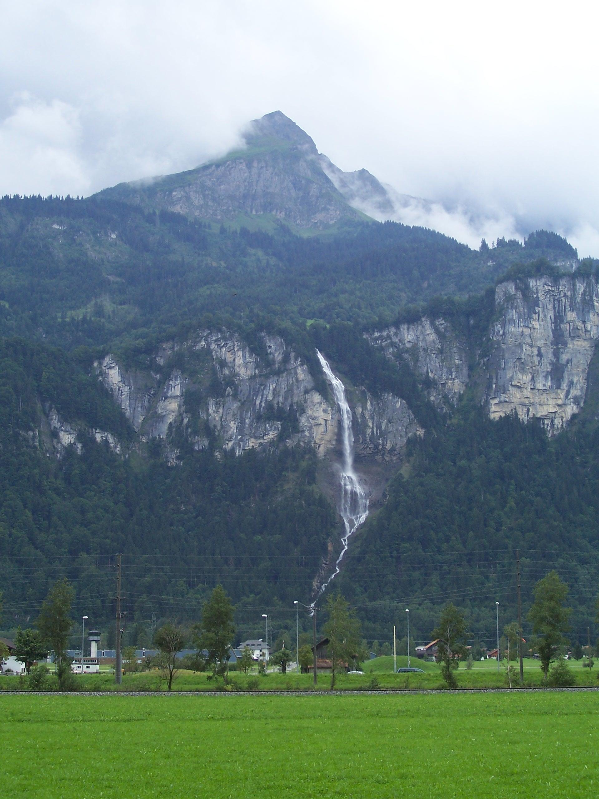
Imagine standing at the foot of a sheer rock wall, feeling a cool mist kiss your face as water plummets 140 meters into a pristine gorge. That’s the unforgettable moment awaiting you at Oltschibachfall, one of Obwalden’s best‑kept secrets. While the Swiss Alps are famous for iconic peaks like the Eiger and Jungfrau, the quieter valleys hold hidden gems that rival any postcard. Oltschibachfall offers raw power, dramatic scenery, and a sense of discovery that makes it a must‑see for any traveler exploring central Switzerland.
2. About Oltschibachfall
A Brief Description
- Location: Lungern, Obwalden, Switzerland
- Coordinates: 46.731248 N, 8.114124 E
- Height: 140 m (≈ 460 ft)
- Type: Free‑fall waterfall 🌊
Oltschibachfall drops straight down from a limestone cliff into a narrow, moss‑lined gorge. The water originates from the Oltschibach stream, fed by melt‑water from the surrounding alpine slopes and several small tributaries. Its sheer height makes it one of the tallest waterfalls in the canton of Obwalden, yet it remains relatively unknown outside local hiking circles.
Historical & Cultural Significance
The name “Oltschibach” derives from the old Swiss German word Oltsch (meaning “old”) combined with Bach (stream). Historically, the waterfall and its surrounding valley served as a natural resource for the nearby farming communities, providing water for irrigation and powering small mills. While there are no grand monuments or legends attached to the site, the waterfall has long been a point of local pride—a symbol of the region’s unspoiled natural power.
Why It Matters
Oltschibachfall is more than a scenic backdrop; it’s an ecological hotspot. The constant spray creates a micro‑habitat for mosses, ferns, and a variety of alpine insects. Birdwatchers can spot kingfishers darting along the stream, and the roar of the water often masks the sounds of distant wildlife, offering a uniquely immersive experience.
3. How to Get There
By Public Transport
- Start in Lucerne – Lucerne is the nearest major city with an international airport and excellent rail connections.
- Train to Lungern – Take the SBB regional train (IC or S-Bahn) toward Interlaken Ost and alight at Lungern (≈ 45 minutes). Trains run hourly, and the ride offers spectacular lake and mountain views.
- Bus or Walk – From Lungern station, catch the local bus line LU‑2 toward Kerns and get off at the Oltschibach stop (about 5 minutes). The bus drops you within a short, well‑marked trailhead.
By Car
- From Lucerne: Follow the A2 motorway north to the Lungern exit (Exit 71), then continue on Route 4 for 6 km. Parking is available at the Oltschibach trailhead (a small, free lot).
- From Zurich: Take the A3 to the A2, then follow the same directions from the Lungern exit. The drive takes roughly 1 hour 30 minutes.
Hiking In – The Trail
The final approach to the waterfall is a moderately easy 1.2 km hike (≈ 30 minutes) on a well‑maintained path with wooden walkways and safety railings. Signage in German and English points the way, and the trail gradually ascends, offering increasing vistas of the gorge and surrounding peaks.
4. Best Time to Visit
| Season | What to Expect | Why It’s Ideal |
|---|---|---|
| Spring (April‑May) | Snowmelt swells the Oltschibach, creating a powerful, thunderous flow. Wildflowers begin to bloom along the trail. | Highest water volume; vibrant colors. |
| Summer (June‑August) | Warm weather, longer daylight hours (up to 16 h of daylight). The mist creates pleasant cooling. | Comfortable hiking conditions; ideal for families. |
| Early Autumn (September‑October) | Water levels moderate, foliage turns golden‑amber, fewer crowds. | Photographers love the soft light and autumn hues. |
| Winter (November‑March) | The waterfall may partially freeze, creating icy sculptures; the area is quiet and pristine. | For adventurous souls equipped for snowshoeing or winter trekking. |
Tip: The waterfall is most spectacular when the water volume is high—typically in late spring and early summer. However, if you prefer a calmer flow and fewer visitors, early autumn is perfect.
5. What to Expect
The Senses
- Sight: A 140‑meter ribbon of water plummeting into a dark, moss‑covered gorge. The surrounding cliffs are capped with alpine pines, and on sunny days, rainbows arc through the spray.
- Sound: A deep, resonant roar that can be heard from the trailhead, growing louder as you approach the base.
- Touch: A fine, refreshing mist that settles on your skin, especially near the viewing platform.
- Smell: Fresh, crisp mountain air mixed with the earthy scent of wet stone and pine.
Facilities
- Viewing Platform: A sturdy wooden deck positioned about 30 m from the base, offering safe, unobstructed views.
- Restrooms: Minimalist eco‑toilets at the trailhead (seasonally serviced).
- Picnic Spot: A small clearing with benches near the parking area, perfect for a snack after the hike.
Safety
The trail is well‑marked, but sections near the waterfall can be slippery due to spray. Wear sturdy hiking shoes with good grip, and keep a safe distance from the edge of the gorge. Children should be supervised at all times.
6. Nearby Attractions
While Oltschibachfall is the star, the surrounding region offers several complementary sites that can easily fill a day of exploration.
| Attraction | Type | Distance from Oltschibachfall | Link |
|---|---|---|---|
| Obwalden Weir (0.4 km) | Weir | 0.4 km | Weir 0.4 km |
| Obwalden Weir (0.7 km) | Weir | 0.7 km | Weir 0.7 km |
| Unnamed Waterfall (1.5 km) | Waterfall (Bern) | 1.5 km | Waterfall Bern |
| Wandelbachfall III | Waterfall (Bern) | 1.5 km | Wandelbachfall III |
| Wandelbachfall II | Waterfall (Bern) | 1.6 km | Wandelbachfall II |
All links lead to general information pages; be sure to verify opening hours and trail conditions before you go.
Bonus Spot: The nearby Lake Lungern (Lungerersee) is a short 5‑minute drive from the trailhead. Its crystal‑clear waters are ideal for a relaxing paddle or a lakeside lunch.
7. Travel Tips
- Start Early – Arriving before 9 am helps you beat any lingering crowds and gives you the full daylight for exploring the surrounding area.
- Pack Layers – Alpine weather changes quickly. Bring a waterproof jacket, a warm layer, and a hat. Even in summer, the mist can make it feel cooler.
- Stay Hydrated & Snack Ready – There are no cafés on the trail. Carry water, energy bars, or a light sandwich.
- Footwear Matters – Trail shoes with good tread are essential; avoid sandals or smooth-soled shoes.
- Respect the Environment – Stick to marked paths, carry out all trash, and avoid disturbing the flora and fauna. The area is a protected natural site.
- Photography Tips – Use a polarizing filter to reduce glare on the water and capture vivid colors. Early morning or late afternoon light provides the most dramatic shadows.
- Check Trail Status – During heavy snow or after storms, sections of the path may be closed. The local tourism office in Lungern (website: lungern-tourismus.ch) posts real‑time updates.
- Combine with a Lake Trip – After visiting Oltschibachfall, rent a paddleboat on Lake Lungern for a relaxing end to the day.
Final Thoughts
Oltschibachfall may not appear on every Swiss travel brochure, but that’s exactly why it feels like a secret treasure. Its towering 140‑meter drop, accessible yet rewarding hike, and the surrounding alpine charm make it an unforgettable stop on any Obwalden itinerary. Pack your boots, follow the mist, and let the roar of Oltschibachfall become the soundtrack of your Swiss adventure.
Happy travels, and may the mist of Oltschibachfall inspire your next journey!