Presa de Puentes Viejas – Madrid’s Hidden Dam Oasis
Discover the tranquil beauty of Presa de Puentes Viejas, a lesser‑known dam tucked in the mountains north of the Spanish capital. Perfect for day‑trippers, nature lovers, and anyone looking to escape the city buzz without venturing far.
1. Introduction
Imagine a crystal‑clear lake framed by pine‑covered hills, the gentle hum of water spilling over a concrete wall, and the scent of fresh mountain air filling your lungs. That’s the experience waiting at Presa de Puentes Viejas, a modest yet striking dam located in the municipality of Berzosa del Lozoya, just a short drive from Madrid. While most tourists flock to the Prado or the Royal Palace, this hidden gem offers a peaceful alternative—a place where you can hike, picnic, and soak up the natural scenery that the Community of Madrid keeps under wraps.
If you’re planning a weekend getaway, a family outing, or a solo adventure off the beaten path, keep reading. We’ll walk you through everything you need to know: the dam’s history, how to get there, the best season to visit, what you’ll see on site, nearby attractions, and insider travel tips that will make your trip smooth and unforgettable.
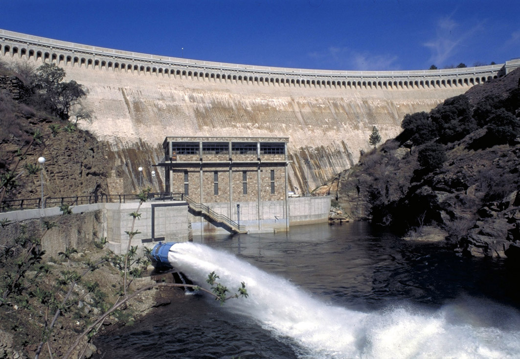
2. About Presa de Puentes Viejas
A Brief Description
Presa de Puentes Viejas (Spanish for “Old Bridges Dam”) is a concrete gravity dam that creates the Puentes Viejas reservoir. Situated at the coordinates 40.993110, -3.570940, the structure lies in the Sierra del Guadarrama mountain range, an area renowned for its lush forests, rugged cliffs, and abundant wildlife. The dam’s primary purpose is water regulation for the surrounding municipalities, but over the years it has become a popular spot for recreation and photography.
History & Significance
The dam was constructed in the mid‑20th century as part of a broader effort to manage the Lozoya River basin, which supplies a large portion of Madrid’s drinking water. Although the exact year of completion is not widely publicized, its name—Puentes Viejas—harks back to historic stone bridges that once spanned the river before the reservoir was filled.
Beyond its functional role, the dam represents a harmonious blend of engineering and nature. Its relatively low profile respects the surrounding landscape, allowing the forested hills to dominate the view. For hikers and cyclists, the reservoir’s shoreline offers a gentle, well‑marked trail that loops around the water, providing multiple viewpoints of the dam itself.
Why It Matters to Travelers
- Scenic Escape: The reservoir mirrors the sky and surrounding peaks, creating picture‑perfect moments at sunrise and sunset.
- Outdoor Activities: Easy walking paths, bird‑watching spots, and informal fishing areas make it a versatile destination.
- Cultural Touchpoint: The name and the old stone bridges that once existed remind visitors of the region’s deep historical roots.
For a quick factual snapshot, you can read the German‑language Wikipedia entry here: Talsperre Puentes Viejas.
3. How to Get There
By Car
The most convenient way to reach Presa de Puentes Viejas is by car. From central Madrid (Puerta del Sol), follow these steps:
- Take the A‑1 (Autovía del Norte) north toward Burgos.
- Exit at M‑601 (the road to Rascafría and Navacerrada).
- Continue on M‑601 for about 30 km, passing the Embalse de El Villar.
- Look for signs directing you to Berzosa del Lozoya and the Puentes Viejas reservoir.
- A small parking area sits near the dam’s visitor viewpoint; it’s free but can fill up on sunny weekends.
The total drive is roughly 55 km and takes about 1 hour depending on traffic. The route offers scenic mountain vistas, so feel free to stop at a viewpoint for a quick photo break.
By Public Transport
While there is no direct train or bus to the dam, you can combine regional transport with a short taxi ride:
- Cercanías (commuter rail) line C‑8 from Madrid’s Chamartín station to Rascafría (≈ 1 hour).
- From Rascafría, catch a local bus 724 toward Berzosa del Lozoya (check the latest schedule on the Consorcio Regional de Transportes de Madrid website).
- The bus stops a few minutes away from the reservoir; you’ll need to walk or take a short taxi ride (≈ 5 km) to the dam itself.
If you’re traveling on a budget or prefer a greener footprint, the train‑plus‑bus combo is a viable option, especially during weekdays when traffic is lighter.
Parking & Accessibility
- Parking: A small lot with around 30 spaces is available near the main viewpoint. Arrive early in summer to secure a spot.
- Accessibility: The main path to the dam is flat and suitable for wheelchairs, though some of the surrounding trails are uneven.
4. Best Time to Visit
| Season | Weather | Visitor Experience | Why It’s Ideal |
|---|---|---|---|
| Spring (Mar‑May) | Mild (12‑20 °C), occasional rain | Blossoming pine forests, fewer crowds | Perfect for photography and bird‑watching |
| Summer (Jun‑Aug) | Warm (22‑30 °C), dry | Longer daylight, lake activities | Ideal for picnics and sunset views, but expect more visitors |
| Autumn (Sep‑Nov) | Cool (15‑22 °C), golden foliage | Crisp air, vibrant colors | Great for hiking and quieter atmosphere |
| Winter (Dec‑Feb) | Cold (5‑12 °C), possible snow | Snow‑capped hills, serene silence | A magical, off‑season experience for those who love winter landscapes |
Overall recommendation: Late spring (April–May) and early autumn (September–October) strike the best balance between pleasant weather, vivid scenery, and manageable visitor numbers.
5. What to Expect
The Landscape
As you approach the reservoir, the first thing you’ll notice is the deep blue water stretching into the horizon, bordered by dense pine and oak groves. The dam itself is a low‑profile concrete wall that subtly blends into the terrain, allowing the surrounding nature to remain the star of the show.
Activities
- Walking & Hiking: A 3‑km loop trail circles the reservoir, offering multiple lookouts. The path is well‑marked and suitable for families.
- Picnicking: Designated grassy spots near the parking area provide ideal settings for a packed lunch. Remember to bring a blanket and keep the area clean.
- Bird‑watching: The area attracts species such as Eurasian black‑cap, golden‑eagle, and various waterfowl. Bring binoculars for a rewarding experience.
- Photography: Sunrise over the dam and sunset reflecting off the water are especially photogenic. The nearby old stone bridges (remnants visible during low water levels) add historic texture to your shots.
Facilities
- Restrooms: Basic facilities are available near the parking lot (seasonally maintained).
- Information Board: A small kiosk displays a map of the trail, safety tips, and a brief history of the dam.
- Refreshments: No permanent café exists on site, but a small kiosk in Berzosa del Lozoya (≈ 2 km away) sells coffee, pastries, and bottled water.
6. Nearby Attractions
While Presa de Puentes Viejas can easily fill a half‑day, the surrounding area offers additional points of interest that are just a short drive away:
| Attraction | Type | Distance from Dam | Why Visit |
|---|---|---|---|
| Unnamed Dam | Dam | 0.8 km | A tiny auxiliary dam that offers a quieter viewpoint of the river. |
| Unnamed Fountain | Fountain | 4.7 km | A charming stone fountain set in a small forest clearing—great for a quick photo stop. |
| Embalse de El Villar | Dam / Reservoir | 5.1 km | Larger lake with kayaking rentals and a visitor center. |
| Unnamed Fountain (2) | Fountain | 5.5 km | A historic water source near the village of Navacerrada, surrounded by walking paths. |
| Unnamed Fountain (3) | Fountain | 6.1 km | Scenic spot near a meadow, perfect for a brief rest during a hike. |
Tip: While the fountains don’t have official names, they are well‑marked on local hiking maps and can be found by following the trail signs from the main road.
If you have extra time, consider extending your trip to the nearby Sierra de Guadarrama National Park for more extensive trekking routes, or head to the historic town of Rascafría, known for its Monasterio de El Paular and traditional mountain cuisine.
7. Travel Tips
- Check Water Levels: The reservoir’s water level can fluctuate seasonally. Low levels reveal the old bridge foundations, while high levels provide broader lake views. Local tourism offices or the Confederación Hidrográfica del Tajo website offer updates.
- Dress in Layers: Mountain weather changes quickly. Bring a light jacket even in summer, and waterproof shoes for spring rain.
- Bring Your Own Snacks: The area has limited food options, so pack a picnic or snacks, especially if you plan to hike the full loop.
- Respect the Environment: The dam sits within a protected watershed. No swimming is allowed, and litter must be taken back to the nearest waste bins in Berzosa del Lozoya.
- Timing for Photography: Arrive 30 minutes before sunrise or 30 minutes before sunset to secure the best spots and avoid crowds. The golden hour light makes the concrete of the dam glow warmly.
- Stay Connected: Mobile reception can be spotty near the reservoir. Download offline maps (e.g., Maps.me or Google Maps offline) before you leave.
- Pet-Friendly: Dogs on leashes are welcome on the main trail, but they must be kept under control near wildlife areas.
Wrap‑Up
Presa de Puentes Viejas may not appear on the typical Madrid travel itinerary, but that’s exactly why it shines. With its serene waters, gentle hiking paths, and the backdrop of the Guadarrama mountains, it offers a perfect slice of nature just a short drive from the bustling capital. Whether you’re chasing sunrise photography, a quiet picnic, or a family-friendly hike, this dam delivers a memorable experience without the crowds.
Pack your camera, hit the road, and let the calm of Presa de Puentes Viejas refresh your senses. Safe travels! 🌿🚗✨