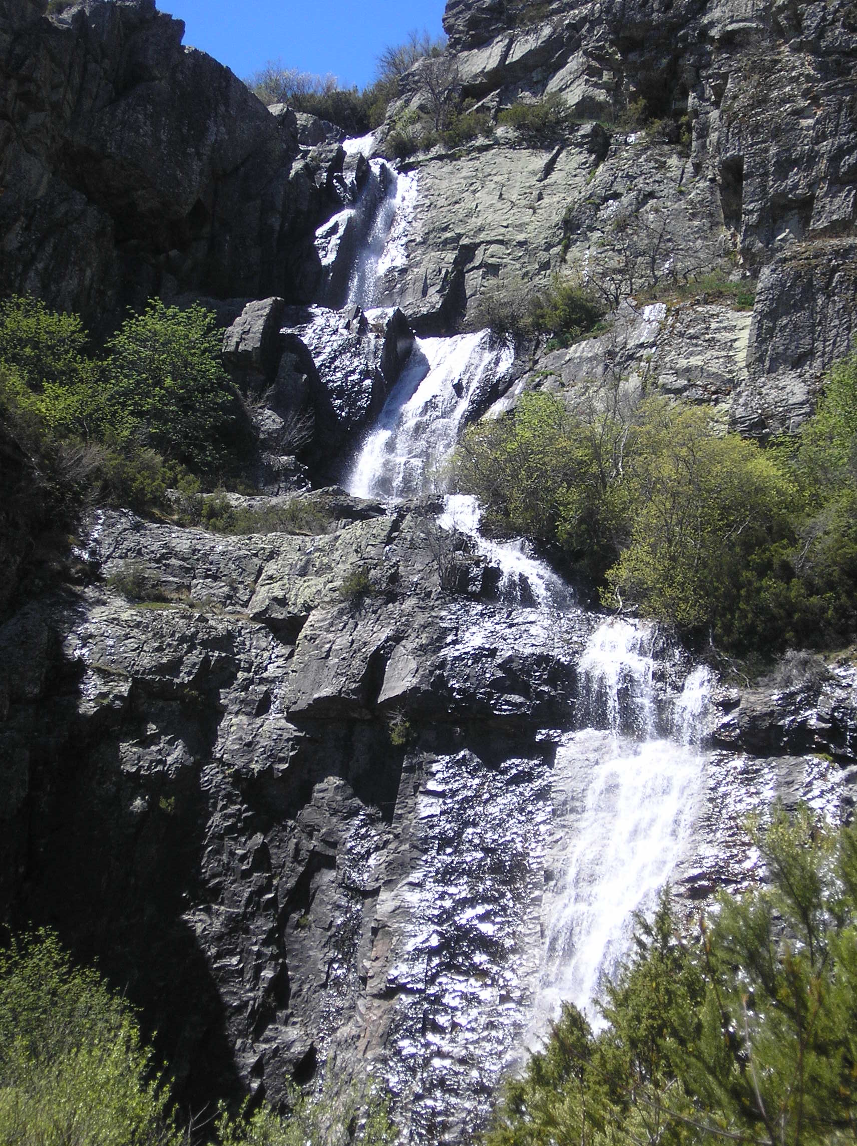
Chorreras de Despeñalagua – The 120‑Metre Jewel of Castile‑La Mancha
Discover the roar, the mist, and the magic of one of Spain’s most dramatic waterfalls.
1. Introduction
Imagine standing at the edge of a sheer 120‑metre drop, the water thundering down a rugged cliff, sending a fine spray that catches the sunlight in a rainbow of droplets. That’s the experience awaiting you at Chorreras de Despeñalagua, the crown‑piece waterfall of Valverde de los Arroyos in the heart of Castile‑La Mancha, Spain. Whether you’re a seasoned hiker, a photography enthusiast, or simply a traveler hungry for hidden natural wonders, this waterfall promises an unforgettable encounter with raw, unspoiled beauty.
2. About Chorreras de Despeñalagua
A Brief Description
- Type: Waterfall 🌊
- Location: Valverde de los Arroyos, Castile‑La Mancha, Spain
- Coordinates: 41.126958 N, ‑3.254485 W
- Height: 120 m (≈ 394 ft)
Chorreras de Despeñalagua drops dramatically from a limestone escarpment into a narrow gorge below. The water source is fed by a network of springs that emerge from the surrounding karst landscape, creating a constant, powerful flow even during the drier months. The waterfall’s name—Chorreras meaning “streams” or “spouts”—captures the relentless cascade that defines the site.
History & Significance
While detailed historical records are scarce, the waterfall has long been a point of reference for locals and travelers alike. Its presence is noted in the Spanish Wikipedia entry for the site, underscoring its cultural relevance within the region. Historically, the surrounding valleys have been used for agriculture and livestock, and the waterfall’s mist‑rich microclimate supports a unique assemblage of flora and fauna, making it an ecological hotspot as well as a scenic landmark.
3. How to Get There
By Air
The nearest major airports are Madrid‑Barajas (MAD) and Valladolid Airport (VLL). From either hub, you can rent a car or catch a regional bus to the town of Valverde de los Arroyos (approximately 2–2.5 hours from Madrid).
By Train
Renfe’s Alvia and Media Distancia services connect Madrid’s Chamartín station to Cuenca, the provincial capital of Castile‑La Mancha. From Cuenca, a local bus or taxi will take you to Valverde de los Arroyos (about 45 km north).
By Car
Driving is the most flexible option. From Madrid, take the A‑3 toward Valencia, then exit onto N‑320 heading north toward Albacete. After passing Albacete, follow the signs for Cuenca and then Valverde de los Arroyos. Parking is available at a small lot near the trailhead (look for the sign “Chorreras de Despeñalagua – Parking”).
On Foot
The waterfall is accessed via a well‑marked hiking trail that starts at the parking area. The path is roughly 2 km round‑trip, with a moderate ascent that rewards you with breathtaking vistas before the final descent to the viewing platform.
4. Best Time to Visit
| Season | Conditions | Why Visit |
|---|---|---|
| Spring (Mar‑May) | Moderate temperatures, abundant spring runoff | Water flow is at its peak, wildflowers line the trail. |
| Summer (Jun‑Aug) | Warm, occasional drought | Still impressive, but water volume may dip; early morning visits avoid heat. |
| Autumn (Sep‑Nov) | Mild weather, colorful foliage | Ideal for photography; mist still present. |
| Winter (Dec‑Feb) | Cooler, occasional frost | Dramatic steam in cold air; fewer crowds. |
Overall recommendation: April–June offers the most reliable water volume and comfortable hiking weather, making it the prime window for most travelers.
5. What to Expect
The Trail Experience
The hike to Chorreras de Despeñalagua is a moderate trek through Mediterranean scrub, limestone outcrops, and occasional pine groves. Trail markers are clear, but a basic map or GPS (using the coordinates 41.126958, ‑3.254485) is advisable. Expect a gentle climb of about 150 m in elevation before reaching the viewing platform.
The Viewpoint
Upon arrival, you’ll stand on a sturdy wooden platform that frames the waterfall perfectly. The roar of water is audible from the platform, and a fine mist often creates a natural veil—perfect for those ethereal photos. On sunny days, rainbows appear in the spray, adding a magical touch.
Wildlife & Flora
The micro‑climate nurtures ferns, mosses, and alpine‑type plants that thrive in the moist environment. Birdwatchers may spot goldfinches, European bee‑eaters, and occasional raptors soaring above the gorge.
Amenities
Facilities are minimal: a picnic table, a public restroom, and a small information kiosk that provides details about the waterfall’s geology and local wildlife. Bring water, snacks, and sturdy shoes—there are no shops on site.
6. Nearby Attractions
While Chorreras de Despeñalagua steals the spotlight, the surrounding area offers several charming spots worth exploring on the same day:
| Attraction | Distance | What to See |
|---|---|---|
| Fuente de la Angostura | 1.2 km | A crystal‑clear spring that feeds local streams. |
| Fuente de la Albariza | 1.2 km | Another pristine spring surrounded by pine. |
| Fuente de Cañamarejo | 1.2 km | A tranquil water source ideal for a quick rest. |
| Fuente del Berrocal | 1.8 km | Slightly larger spring with a small cascade. |
| Fuente de Don Pedro Gordo (1955) | 1.8 km | Historic fountain dating back to the mid‑20th century. |
These springs are part of the same karst system that powers Chorreras de Despeñalagua, offering a chance to see how water shapes the landscape in multiple forms. They’re all reachable via short, easy walking paths from the main trailhead.
7. Travel Tips
| Tip | Details |
|---|---|
| Pack Light, Pack Smart | Bring a waterproof jacket, sturdy hiking boots, and a compact rain cover for your camera. |
| Timing | Arrive early (7–8 am) during peak season to avoid crowds and capture the soft morning light. |
| Safety | The viewing platform has railings, but the rocks near the base are slippery. Stay behind barriers and keep children supervised. |
| Leave No Trace | Carry out all litter, stay on marked paths, and respect the delicate vegetation near the springs. |
| Connectivity | Mobile signal can be spotty; download offline maps (Google Maps, Maps.me) before you set out. |
| Local Cuisine | After the hike, stop in Valverde de los Arroyos for gazpacho manchego or cuchifritos at a family‑run tavern. |
| Currency | Spain uses the Euro (€); most places accept cards, but keep some cash for small vendors. |
| Language | Spanish is the primary language. Learning a few phrases (“¡Hola!”, “Gracias”, “¿Dónde está…?”) goes a long way. |
Final Thought
Chorreras de Despeñalagua isn’t just a waterfall; it’s a living portrait of Castile‑La Mancha’s rugged charm, a place where water, stone, and sky converge in a spectacular display. With its impressive 120‑metre drop, accessible trails, and surrounding springs, it offers a perfect day‑trip for anyone exploring central Spain. Pack your sense of adventure, follow the trail, and let the mist of Despeñalagua refresh both body and spirit.
Happy travels, and may your next waterfall be as awe‑inspiring as this one!