Embalse de Los Corrales de Buelna – A Hidden Gem in Cantabria’s Green Heart
If you think Cantabria is only about dramatic cliffs, historic towns, and coastal surf, think again. Tucked in the rolling hills of Cartes lies Embalse de Los Corrales de Buelna, a tranquil dam that offers a slice of pure, unspoiled nature. Whether you’re a photography enthusiast, a family looking for a peaceful day out, or a road‑tripper craving off‑the‑beaten‑path scenery, this modest reservoir deserves a spot on your Cantabrian itinerary.
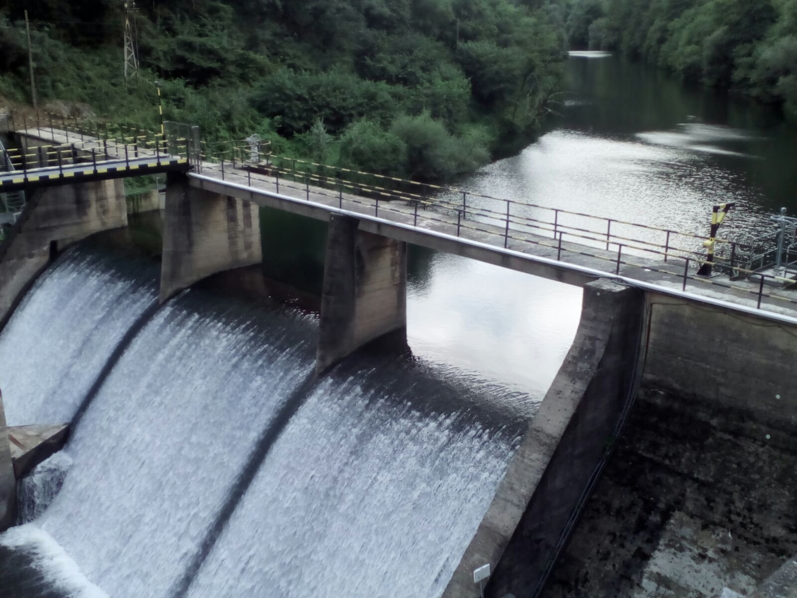
About Embalse de Los Corrales de Buelna
Located at 43.303726 N, ‑4.073612 W in the municipality of Cartes, the Embalse de Los Corrales de Buelna is one of Cantabria’s lesser‑known water bodies. Though the exact height and altitude of the dam are not publicly documented, its presence is unmistakable: a calm, mirror‑like surface framed by pine‑covered slopes and the gentle hum of rural life.
The reservoir was created to serve multiple purposes—primarily water supply for the surrounding agricultural lands and flood control for the nearby valleys. Over the decades, the dam has also become an informal gathering point for locals who fish, picnic, and enjoy the crisp mountain air. Its strategic location near the Saja‑Nansa river basin makes it an essential piece of Cantabria’s water‑management network, even if it doesn’t boast the fame of larger Spanish dams.
From a cultural standpoint, the embalse reflects the region’s long tradition of harmonising human engineering with nature. The modest infrastructure blends seamlessly into the landscape, allowing visitors to feel as though they’ve stepped into a living postcard rather than a bustling tourist hotspot.
Quick fact: The embalse is mentioned on the Spanish‑language Wikipedia page for Embalse de Los Corrales de Buelna – a good starting point if you love digging into the details before you travel.
How to Get There
By Car
The most convenient way to reach the reservoir is by car. From Santander, Cantabria’s capital, take the A-8 highway westward for about 30 km, then exit onto N-634 toward Cartes. Follow the signs for Cartes‑Los Corrales; the road will gradually wind up into the hills, and you’ll spot the dam’s blue‑green water glimmering on the right. The total drive is roughly 45 minutes (≈ 55 km).
- Parking: A small, free parking area sits near the main access road. It fills quickly on weekends, so arriving early (before 10 am) is advisable.
By Public Transport
Public buses to Cartes run from Santander and Torrelavega (lines 210 and 212). Once you reach the Cartes bus stop, you’ll need to either walk (≈ 2 km uphill) or catch a local taxi for the final stretch to the embalse. Note that service frequency drops after 6 pm, so plan accordingly.
By Bike or Hiking
For the adventurous, the Camino del Embalse trail starts at the village of Los Corrales and offers a scenic 7 km ride or hike to the dam. The route passes through oak forests, small farms, and offers several viewpoints perfect for a quick coffee break.
Best Time to Visit
| Season | Weather & Highlights | Why Visit |
|---|---|---|
| Spring (Mar‑May) | Mild temperatures (12‑18 °C), blooming wildflowers, migratory birds returning. | Ideal for photography and gentle walks. |
| Summer (Jun‑Aug) | Warm days (22‑28 °C) and long daylight hours. The water is calm, perfect for kayaking or paddle‑boarding. | Best for water‑based recreation, but expect more local families. |
| Autumn (Sep‑Nov) | Golden foliage, cooler evenings, occasional mist over the reservoir. | A photographer’s dream; fewer crowds. |
| Winter (Dec‑Feb) | Quiet, occasional frost, and dramatic cloudscapes. | Perfect for solitude and contemplative hikes. |
Pro tip: The period from late April to early June offers a sweet spot—pleasant weather, blooming nature, and fewer tourists than the peak summer months.
What to Expect
When you arrive, the first impression is one of serene simplicity. The reservoir’s surface often lies perfectly still, reflecting the surrounding pine forests and the occasional cloud drifting overhead. A short, well‑maintained path circles the water, allowing you to choose a viewpoint that matches your mood:
- Picnic spots: Small wooden tables and benches are scattered near the northern shore. Pack a picnic of local Cantabrian cheese, chorizo, and a bottle of Miel de Cantabria for a truly regional experience.
- Fishing: The embalse is stocked with trout and carp. Local anglers are friendly and will gladly share a tip or two. Remember to bring a fishing license (available at nearby town halls).
- Birdwatching: Early mornings bring a chorus of songbirds, and you may spot European kingfishers darting over the water’s edge.
- Water activities: While there is no formal rental service, you can bring your own kayak or paddleboard. The calm waters make for a relaxed glide, especially during the low‑wind afternoons of early summer.
The surrounding hills provide gentle elevation changes, perfect for a short hike or a leisurely bike ride. Keep an eye out for traditional stone casa rurales (country houses) that dot the landscape—many of them now serve as charming guesthouses if you decide to extend your stay.
Nearby Attractions
Exploring the area around Embalse de Los Corrales de Buelna opens up a handful of delightful side trips, all within a 5‑km radius:
| Attraction | Distance | What to See | Link |
|---|---|---|---|
| Unnamed Dam (1.6 km) | 1.6 km | Small auxiliary reservoir, great for a quick photo stop. | View on Google Maps |
| Fuente de las Palomas (spring) | 2.9 km | A crystal‑clear spring surrounded by pine, perfect for a refreshing drink. | Fuente de las Palomas |
| Fuente Fría (spring) | 3.0 km | Known for its chilly, mineral‑rich water; ideal for a short hike. | Fuente Fría |
| Unnamed Dam (4.1 km) | 4.1 km | Another modest dam offering panoramic views of the valley. | View on Google Maps |
| Unnamed Dam (4.5 km) | 4.5 km | Slightly larger, with a small walking trail around its perimeter. | View on Google Maps |
Tip: Combine a visit to the embalse with a circuit of the three springs (Fuente de las Palomas, Fuente Fría, and the nearby unnamed spring). The loop is roughly 8 km and showcases Cantabria’s pristine water sources.
Travel Tips
- Dress in layers – Cantabrian weather can shift quickly, especially in the hills. A light waterproof jacket is a smart addition.
- Bring cash – Small rural cafés and kiosks often accept only cash or local card terminals.
- Respect the environment – The area is a protected water source. Pack out all litter, and avoid swimming in the springs unless signage permits it.
- Check opening hours – While the embalse itself is open year‑round, nearby facilities (picnic shelters, restrooms) may close after 7 pm in winter.
- Parking fee – There is no fee for the free lot near the dam, but a small municipal charge may apply during high‑season weekends.
- Local cuisine – Don’t miss trying cocido montañés (mountain stew) at a nearby tavern in Cartes; it’s the perfect post‑hike comfort food.
- Safety first – If you decide to kayak, wear a life jacket and be aware that the water can be unexpectedly cold, even in summer.
Wrap‑Up
Embalse de Los Corrales de Buelna may not have the towering stature of Spain’s famous dams, but its quiet charm, lush surroundings, and authentic Cantabrian vibe make it a standout destination for travelers seeking genuine nature experiences. Pair it with a few short hikes, a sip from a mountain spring, and a taste of local cuisine, and you’ve crafted a day‑trip that feels both refreshing and deeply rooted in the region’s heritage.
So pack your camera, fill up the car’s tank, and set your GPS to 43.303726, ‑4.073612. Cantabria’s hidden reservoir is waiting to become your next favorite travel story. Safe travels! 🌿🚗🗺️