Discover Barragem da Apartadura – Portugal’s Hidden Dam Gem
If you’re wandering the rolling hills of Alentejo and crave a tranquil spot where engineering meets nature, Barragem da Apartadura in Marvão, Portalegre, should be at the top of your itinerary.
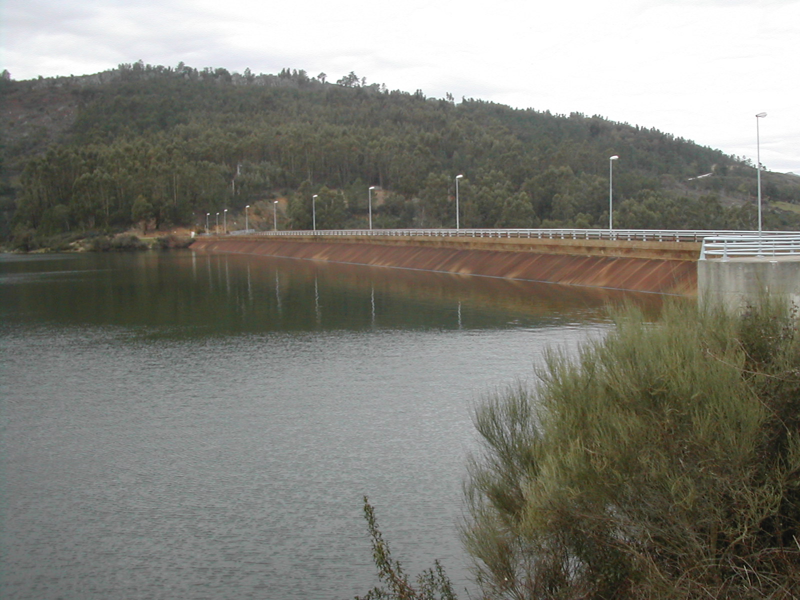
1. Introduction
Tucked away at 598 m above sea level, the Barragem da Apartadura is more than a concrete structure – it’s a quiet sanctuary for hikers, photographers, and anyone who loves a good viewpoint over a shimmering reservoir. While Portugal’s coastline steals most of the limelight, the interior’s dams and reservoirs offer a different kind of beauty: rugged landscapes, crisp mountain air, and the gentle murmur of water against stone. In this guide, we’ll explore why this modest‑sized dam (44.5 m high) is a must‑visit for off‑the‑beaten‑path travelers exploring the Alentejo region.
2. About Barragem da Apartadura
A Brief Description
- Type: Dam (concrete gravity)
- Location: Marvão, Portalegre, Portugal
- Coordinates: 39.350465 °N, -7.383857 °W
- Height: 44.5 m
- Altitude: 598 m above sea level
The dam was built to regulate the flow of the local river system, providing water for irrigation and supporting the surrounding agricultural lands. Though its primary function is utilitarian, the reservoir created by the dam has become a natural haven for wildlife and a picturesque backdrop for outdoor activities.
History & Significance
While detailed construction dates are scarce, the Barragem da Apartadura reflects the mid‑20th‑century push in Portugal to develop water infrastructure in the semi‑arid Alentejo interior. By capturing seasonal runoff, the dam helps sustain the region’s vineyards, olive groves, and livestock farms. Its modest height (44.5 m) makes it accessible for visitors—there are safe viewing platforms and walking trails that let you get up close without the industrial feel of larger hydro‑electric projects.
For a deeper dive into the dam’s background, check the Portuguese Wikipedia entry: Barragem da Apartadura.
3. How to Get There
By Air & Car
- Fly into Lisbon Airport (LIS). The capital’s international hub is the most convenient entry point for travelers from abroad.
- Rent a car and head north on the A2/E1 motorway, then switch to the A23 toward Portalegre. The drive from Lisbon to Marvão is roughly 2.5 hours (≈210 km).
- Follow signs for Marvão on the N231. The dam sits just outside the historic town, at the coordinates listed above.
Public Transport (If You Prefer Not to Drive)
- Train: Take the Comboios de Portugal (CP) service from Lisbon’s Oriente station to Portalegre‑São Pedro. Trains run several times a day, with a journey time of about 3 hours.
- Bus: From Portalegre’s bus terminal, catch a regional bus toward Marvão. The final stop is a short walk from the dam’s parking area.
Parking & Access
A small, free parking lot sits at the main visitor area. From there, a well‑marked trail leads to the reservoir’s edge and a panoramic viewpoint. The site is open year‑round, but the parking area can fill up during peak summer weekends, so arriving early is advisable.
4. Best Time to Visit
| Season | Weather | Why Visit |
|---|---|---|
| Spring (March‑May) | Mild temperatures (15‑22 °C), blooming wildflowers | Ideal for photography, comfortable hiking, and spotting migratory birds. |
| Summer (June‑August) | Warm to hot (25‑35 °C) | Longer daylight hours; perfect for picnics by the water, but bring sun protection. |
| Autumn (September‑October) | Pleasant (18‑26 °C), fewer crowds | The reservoir reflects golden foliage; great for peaceful walks. |
| Winter (November‑February) | Cool, occasional rain (10‑15 °C) | Low visitor numbers; excellent for solitude and dramatic sky shots. |
Tip: The best light for photos is early morning (sunrise) and late afternoon (golden hour). Spring and early autumn usually offer the clearest skies.
5. What to Expect
Scenic Views
From the main viewpoint, you’ll see the turquoise reservoir framed by the rolling Alentejo hills. The dam’s concrete wall creates a striking contrast against the surrounding limestone terrain. On clear days, you can even spot the historic walls of Marvão perched on its hilltop, just a few kilometers away.
Wildlife & Birdwatching
The reservoir attracts a variety of waterfowl, including teal, mallard, and occasional kingfishers. The surrounding scrubland is home to rabbits, foxes, and the occasional wild boar—always keep a safe distance.
Activities
- Walking & Hiking: A 2‑km loop trail circles the reservoir, with gentle elevation changes suitable for all fitness levels.
- Photography: The dam’s geometric lines, reflections on the water, and surrounding flora make for compelling compositions.
- Picnicking: Designated grassy spots near the water are perfect for a relaxed lunch. Remember to carry out all trash.
Facilities
- Restrooms: Basic facilities near the parking lot (seasonally maintained).
- Information Board: Provides a brief overview of the dam’s history and local flora/fauna.
- No Swimming: For safety reasons, swimming is prohibited, but you can wade in shallow areas if you wish.
6. Nearby Attractions
While the dam itself offers a tranquil escape, the surrounding area is dotted with charming natural sites worth exploring:
- Spring (1.9 km away) – A crystal‑clear spring bubbling from the hillside, perfect for a short detour and a splash of fresh mountain water.
- Spring (2.2 km away) – Another secluded spring surrounded by native shrubs, ideal for birdwatching.
- Weir (2.5 km away) – An historic weir that once helped channel water to nearby farms; the stonework is a glimpse into traditional water management.
- Weir (2.9 km away) – Slightly larger than its neighbor, this weir offers a picturesque spot for a quick photo session.
- Fonte dos Coelhos (Fountain, 3.4 km away) – A charming stone fountain named after the local rabbit population; legend says the water has a refreshing taste.
All distances are measured from the dam’s main viewpoint.
7. Travel Tips
| Tip | Details |
|---|---|
| Bring a map or GPS | Cell reception can be spotty in the hills; offline maps ensure you stay on track. |
| Dress in layers | Temperatures shift quickly with altitude; a light jacket is useful even in summer mornings. |
| Footwear | Sturdy walking shoes or hiking boots are recommended for the uneven trail surfaces. |
| Stay hydrated | Even on cooler days, the altitude can make you feel thirsty faster than at sea level. |
| Respect the environment | The area is a protected water catchment; avoid littering and stay on marked paths. |
| Check opening hours | While the dam is generally open year‑round, the visitor information board may note seasonal maintenance closures. |
| Local cuisine | After your visit, stop in Marvão for traditional Alentejo dishes—try the “açorda de alho” (garlic bread soup) or a glass of regional red wine. |
| Currency | Portugal uses the Euro (€). Small vendors may prefer cash, so keep some on hand. |
| Language | Portuguese is the official language; basic phrases (“por favor,” “obrigado”) go a long way. |
Final Thoughts
Barragem da Apartadura may not have the fame of Portugal’s coastal landmarks, but its serene reservoir, panoramic vistas, and proximity to hidden springs and historic weirs make it a rewarding stop for any traveler seeking authentic Alentejo experiences. Whether you’re a seasoned hiker, a photography enthusiast, or simply looking for a peaceful spot to unwind, the dam offers a slice of Portuguese countryside that feels both timeless and refreshingly untouched.
Pack your camera, hit the road, and let the gentle hum of water guide you to one of Portugal’s best‑kept secrets. Safe travels!