Discover Diga di Monte Lerno – Sardinia’s Hidden Engineering Gem
If you think Sardinia is only about turquoise beaches and ancient ruins, think again. Tucked in the rugged interior of the island near the charming town of Pattada, Diga di Monte Lerno rises 67.5 m above the landscape, offering travelers a unique blend of engineering marvel, tranquil nature, and authentic Sardinian culture.
1. Introduction
Imagine standing at the edge of a crystal‑clear reservoir, the water reflecting the jagged silhouette of a 67‑meter‑high dam, while the Sardinian sun paints the surrounding hills in golden light. That’s the experience waiting at Diga di Monte Lerno – a lesser‑known but unforgettable stop for road‑trippers, hikers, and anyone craving a slice of authentic Sardinia away from the crowded coastal resorts.
In this guide we’ll explore the dam’s story, how to reach it, the best season to visit, what you’ll see on site, and the natural wonders that lie just a short drive away.
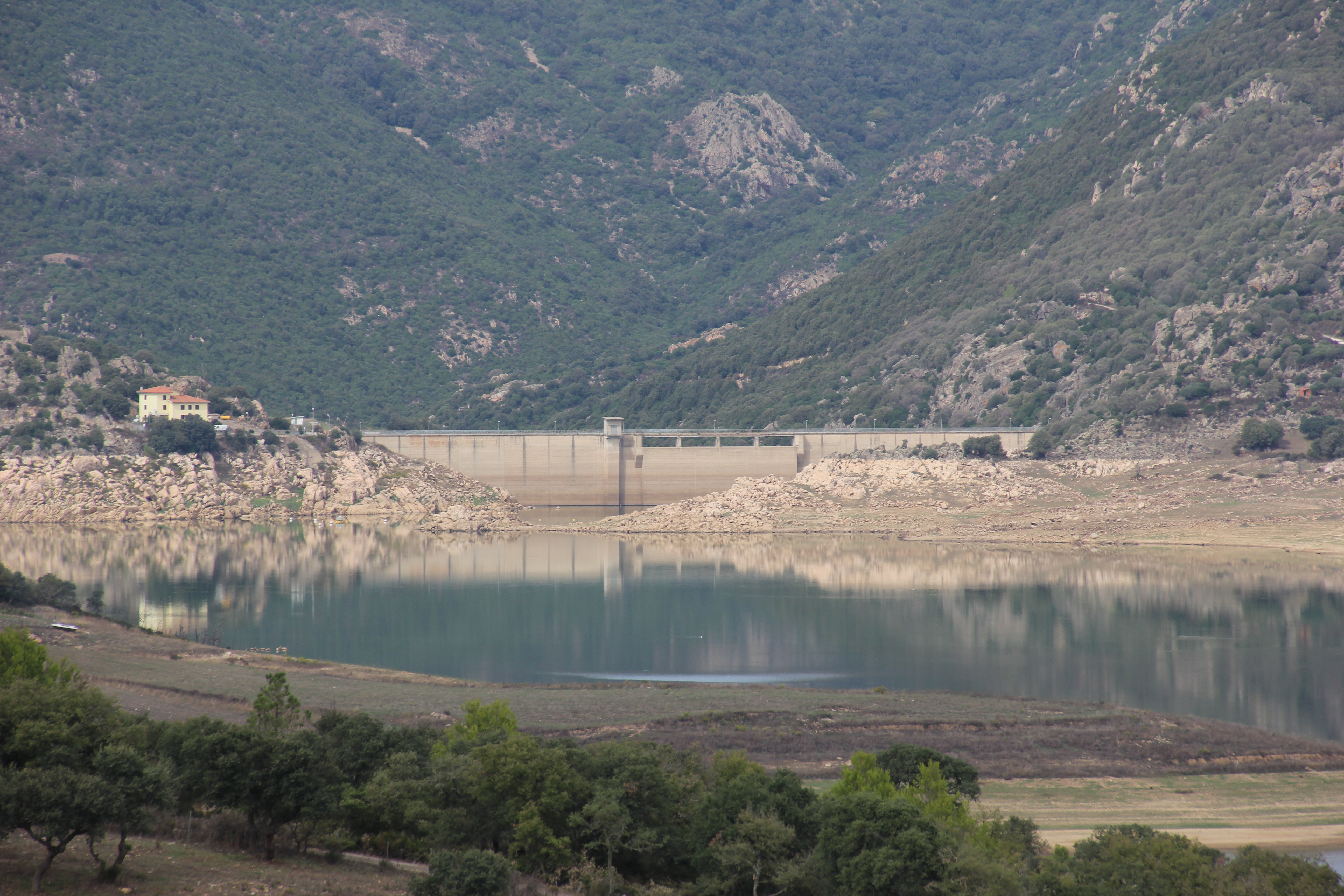
2. About Diga di Monte Lerno
Location: Pattada, Sardinia, Italy
Coordinates: 40.591063 N, 9.151783 E
Height: 67.5 m
Built to regulate water flow in the interior of Sardinia, Diga di Monte Lerno plays a crucial role in supplying irrigation water to the surrounding agricultural valleys. While the exact year of construction is not widely publicised, the dam’s robust concrete structure reflects the post‑war wave of infrastructure projects that modernised Italy’s rural regions.
Beyond its utilitarian purpose, the dam has become a quiet landmark for locals and visitors alike. The reservoir created by the dam—often called Lake Monte Lerno by hikers—offers a serene setting for picnics, bird‑watching, and photography. Its remote location means you’ll encounter few crowds, allowing you to soak in the peaceful atmosphere and capture the dramatic contrast between the engineered stone and the untouched Mediterranean flora.
For a quick factual overview, check the Italian Wikipedia entry: Diga di Monte Lerno.
3. How to Get There
By Car
The most flexible way to reach Diga di Monte Lerno is by renting a car in one of Sardinia’s major hubs—Cagliari, Olbia, or Alghero—and heading north‑west toward the town of Pattada. From the SS131 (the island’s main highway), follow the signs for Pattada and then take the local road SP 41 that winds through rolling pastures and pine‑covered hills.
- From Cagliari: ~180 km, about 2.5 hours
- From Olbia: ~150 km, about 2 hours
- From Alghero: ~120 km, about 1.8 hours
The final stretch involves a narrow, well‑maintained mountain road; a compact or midsize vehicle is ideal. Parking is available in a small lot near the dam’s visitor area.
By Public Transport
Public buses connect Pattadi to larger cities, but service is infrequent and stops short of the dam itself. If you prefer not to drive, consider taking a bus to Pattada and then hiring a local taxi for the 5‑km final leg.
By Bike or Hike
For the adventurous, the surrounding Gennargentu National Park offers marked trails that pass near the reservoir. However, the terrain is rugged, and the road to the dam includes steep sections, so only experienced cyclists should attempt it.
4. Best Time to Visit
Sardinia enjoys a Mediterranean climate, but the interior where Diga di Monte Lerno sits experiences more pronounced seasonal swings than the coastal zones.
| Season | Weather | Why Visit? |
|---|---|---|
| Spring (April‑June) | Mild temperatures (15‑22 °C), blooming wildflowers | Ideal for photography, comfortable hiking, and spotting migratory birds around the reservoir. |
| Summer (July‑August) | Warm to hot (25‑30 °C), occasional thunderstorms | Longer daylight hours for exploring nearby attractions, but bring sun protection and plenty of water. |
| Autumn (September‑October) | Pleasant (18‑24 °C), golden foliage | Perfect for tranquil walks, fewer tourists, and crisp air for picnics by the water. |
| Winter (November‑March) | Cool (8‑14 °C), occasional rain | The dam is still accessible, but some hiking paths may be muddy; great for those seeking solitude. |
Peak recommendation: Late spring (mid‑May to early June) offers the best combination of comfortable weather, vibrant scenery, and manageable visitor numbers.
5. What to Expect
Scenic Views
Approaching the dam, you’ll first notice the sheer concrete wall rising against the backdrop of the Gennargentu mountains. The reservoir stretches like a mirror, reflecting the sky and surrounding pine forests. Sunrise and sunset cast a warm glow that makes the water shimmer—a photographer’s dream.
Quiet Recreation
There is no formal beach or swimming area, but locals often use the shore for picnics and bird‑watching. Bring a blanket, a packed lunch, and binoculars to observe species such as the European bee‑eater and common kingfisher that frequent the water’s edge.
Educational Insight
A modest information board near the parking lot explains the dam’s purpose, its role in regional water management, and basic engineering facts (e.g., the 67.5 m height). While guided tours are not regularly scheduled, the staff at the nearby municipal office in Pattada can answer basic questions.
Limited Facilities
Facilities are minimal: a small restroom block, a shaded bench area, and a parking lot. No souvenir shop or café is present, so plan to bring your own refreshments.
6. Nearby Attractions
After soaking in the atmosphere at Diga di Monte Lerno, venture a short distance to discover other natural gems that showcase Sardinia’s inland beauty.
| Attraction | Distance from Dam | What to See | Link |
|---|---|---|---|
| S'Abba Lughida (spring) | 2.8 km | A crystal‑clear spring emerging from limestone, perfect for a quick dip or a peaceful stop. | S'Abba Lughida |
| Le Piscine (fountain) | 4.1 km | A small natural fountain surrounded by olive groves; great for photos and a short walk. | Le Piscine |
| Fonte Sa Casina (spring) | 4.7 km | Another pristine spring, known for its mineral‑rich water and shaded picnic area. | Fonte Sa Casina |
| [Unnamed Dam] | 6.9 km | A second dam in the region offering a different perspective on Sardinian water infrastructure. | Nearby Dam |
| [Unnamed Fountain] | 8.2 km | A charming rural fountain that serves as a gathering spot for local shepherds. | Nearby Fountain |
Tip: Combine these sites into a half‑day “water‑trail” loop: start at Diga di Monte Lerno, head to S'Abba Lughida, then continue to Le Piscine and finish at Fonte Sa Casina. The short drives let you enjoy the rolling countryside without feeling rushed.
7. Travel Tips
| Tip | Details |
|---|---|
| Bring Cash | Small villages like Pattada often accept only cash for parking fees or local snacks. |
| Dress in Layers | Inland Sardinia can be cool in the mornings and warm by noon, especially in spring and autumn. |
| Stay Hydrated | Even on mild days, the sun can be intense; carry a reusable water bottle. |
| Respect the Environment | The area is a protected water source—avoid littering and stay on marked paths. |
| Check Road Conditions | Winter rains can make the mountain road slippery; verify local traffic updates before setting out. |
| Timing | Arrive early (before 10 am) to enjoy the dam in soft morning light and avoid any occasional afternoon crowds. |
| Local Cuisine | Stop in Pattada for pecorino sardo (sheep cheese) and culurgiones (stuffed pasta) – perfect fuel for a day of exploring. |
| Photography | Use a polarizing filter to reduce glare on the water and bring a tripod for sunrise or sunset shots. |
| Language | Basic Italian phrases will go a long way; locals appreciate attempts at “Buongiorno” and “Grazie”. |
Final Thought
Diga di Monte Lerno may not appear on the typical Sardinia travel itineraries, but that’s precisely why it feels like a hidden treasure. Whether you’re an engineering enthusiast, a nature lover, or a traveler seeking off‑the‑beaten‑path serenity, the dam and its surrounding springs offer a rewarding slice of Sardinian life that’s both authentic and unforgettable. Pack your camera, hop in the car, and let the quiet beauty of Monte Lerno’s waters refresh your wanderlust.
Happy travels!