Diga della Maina – A Hidden Alpine Gem in Friuli Venezia Giulia
Discover the towering 128‑metre dam that blends engineering marvel with breathtaking Alpine scenery, and learn how to make the most of your visit to Sauris di Sotto.
Introduction
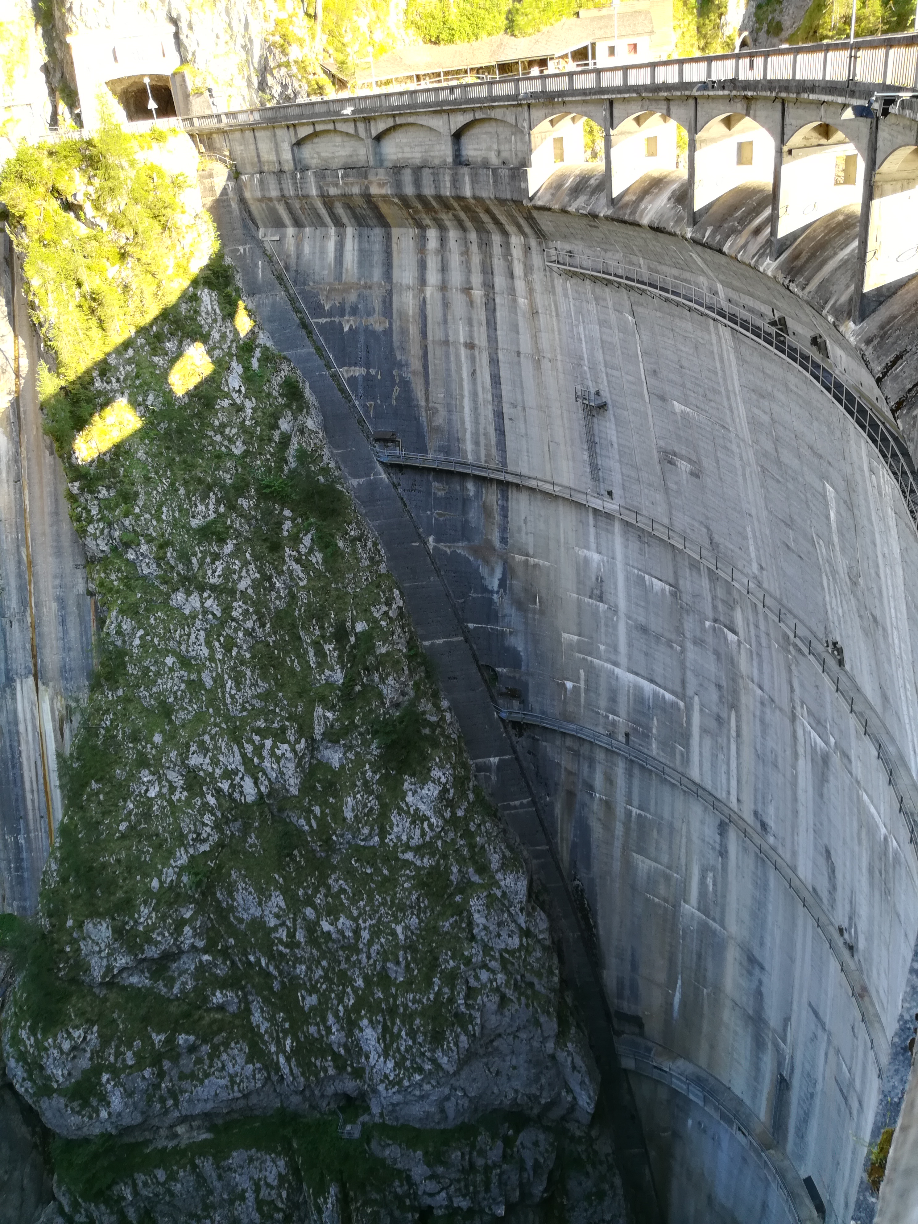
Imagine standing at the edge of a massive concrete wall that rises 128 metres above the valley floor, the water below shimmering like a giant mirror of the surrounding peaks. The Diga della Maina (also known as the Diga di Sauris) offers exactly that – a dramatic, lesser‑known dam nestled in the heart of the Friuli Venezia Giulia region of Italy. While most travelers head straight for the famous Dolomites or the Adriatic coast, this impressive structure gives you a rare glimpse into Italy’s Alpine hydro‑engineering heritage, all set against pristine mountain vistas.
Whether you’re a photography enthusiast, a lover of industrial heritage, or simply craving a peaceful spot away from the crowds, Diga della Maina makes a compelling addition to any Italian travel itinerary.
About Diga della Maina
What is it?
- Type: Concrete gravity dam 🏗️
- Location: Sauris di Sotto, Friuli Venezia Giulia, Italy
- Coordinates: 46.448223 N, 12.736307 E
- Height: 128 m
The dam harnesses the waters of the Maina River, creating a reservoir that feeds the regional hydroelectric network. Its towering height makes it one of the most prominent engineering works in the province of Udine, while its sleek, utilitarian design blends surprisingly well with the surrounding alpine landscape.
A Brief History
The structure is part of the broader Sauris hydro‑electric system, which was developed in the mid‑20th century to meet the growing energy demands of post‑war Italy. Though specific construction dates are scarce, the dam’s presence has been documented in regional archives and on the Italian Wikipedia page for the Diga di Sauris. Over the decades, the dam has become a vital component of local water management, flood control, and renewable energy production.
Why It Matters
- Renewable Energy: The dam contributes to Italy’s commitment to clean energy by generating hydroelectric power without emitting greenhouse gases.
- Water Regulation: It helps regulate river flow, protecting downstream communities from sudden floods.
- Cultural Landscape: The dam is an integral part of the Alpine cultural heritage, illustrating how human ingenuity can coexist with nature.
How to Get There
By Car
The most flexible way to reach Diga della Maina is by car. From Udine (the regional capital, about 80 km away), follow the SS13 highway northward toward Sauris. After passing the town of Sauris di Sotto, look for signposts directing you to the dam and its parking area. The drive takes roughly 1.5 hours and offers spectacular mountain road scenery—perfect for a scenic road‑trip playlist.
Public Transport
- Train: Take a regional train from Udine to Tarvisio, the nearest major rail hub.
- Bus: From Tarvisio, catch a local bus to Sauris di Sotto (check the Friuli‑Venezia‑Giulia public transport website for current schedules).
- Taxi/Shared Ride: Once in Sauris, a short taxi ride or a local shared‑ride service can drop you off at the dam’s visitor area.
Pro tip: Bus services in the Alpine valleys can be infrequent, especially outside the summer months. If you’re traveling on a tight schedule, renting a car is the safest bet.
Parking & Accessibility
A modest parking lot sits just a few minutes’ walk from the dam’s main viewpoint. The site is wheelchair‑accessible via a gently sloping path, though the steep terrain beyond the viewing platform may be challenging for those with limited mobility.
Best Time to Visit
| Season | Weather | Highlights |
|---|---|---|
| Spring (April–June) | Mild temperatures (10–20 °C), blooming alpine flora | Ideal for photography; the reservoir reflects fresh green valleys. |
| Summer (July–August) | Warm days (20–30 °C), occasional thunderstorms | Perfect for hiking; longer daylight hours let you explore nearby weirs and springs. |
| Autumn (September–October) | Cool, crisp air (10–18 °C), golden foliage | Spectacular colors; fewer tourists, great for peaceful contemplation. |
| Winter (November–March) | Snowy, sub‑zero temps; the dam may be partially covered in ice | Dramatic snowy landscape; only for experienced winter hikers with proper gear. |
Recommendation: Late spring (mid‑May to early June) offers the best combination of pleasant weather, vibrant scenery, and manageable crowds.
What to Expect
The Viewpoint
A short, well‑marked trail leads from the parking area to a panoramic platform that hugs the dam’s crest. From here, you can admire the sheer 128‑metre wall and the tranquil reservoir that stretches into the valley. On clear days, the surrounding peaks of the Julian Alps frame the scene, creating a picture‑perfect backdrop for Instagram or a serene spot for a coffee break.
The Soundscape
Unlike bustling tourist hotspots, Diga della Maina is relatively quiet. You’ll hear the gentle hum of turbines (if the facility allows a brief observation) and the occasional splash of water spilling over the spillway—sounds that blend technology with nature.
Activities
- Photography: Capture the contrast between concrete and alpine flora. Sunrise and sunset light create dramatic shadows on the dam’s façade.
- Short Hikes: Follow marked trails that loop around the reservoir, leading to the nearby spring (1.6 km away) and a series of historic weirs (3.3–3.5 km away).
- Educational Visits: If you’re interested in the engineering side, check the local tourist office for scheduled guided tours—some may include a brief look inside the control room (subject to safety regulations).
Nearby Attractions
While Diga della Maina is the star of the show, the surrounding area offers several other natural and cultural points of interest that can easily be added to a day‑trip itinerary.
| Attraction | Distance | Type | Quick Info |
|---|---|---|---|
| Local Spring | 1.6 km | Natural spring | A crystal‑clear mountain spring perfect for a quick refill or a short nature walk. |
| Diga del Novarza | 2.7 km | Dam | Another impressive hydro‑electric dam that showcases different engineering techniques. |
| Weir #1 | 3.3 km | Weir | Small water‑management structure, great for observing traditional Alpine water‑control methods. |
| Weir #2 | 3.4 km | Weir | Similar to the first, offers a quiet spot for picnics and birdwatching. |
| Weir #3 | 3.5 km | Weir | The furthest weir, situated near a forest trail that leads to panoramic viewpoints. |
Explore More: For detailed maps and trail descriptions, visit the Friuli Venezia Giulia tourism portal or stop by the Sauris di Sotto municipal office.
Travel Tips
- Dress in Layers – Alpine weather can shift quickly. Bring a waterproof jacket, a warm sweater, and sturdy hiking shoes.
- Stay Hydrated – Even at moderate altitudes, walking can be taxing. Carry a reusable water bottle (you can refill at the nearby spring).
- Respect the Environment – The dam area is a protected water‑management zone. Stick to marked paths, avoid littering, and obey any signage about restricted zones.
- Check Opening Hours – While the viewpoint is generally open year‑round, certain sections (e.g., control‑room tours) may be seasonal or require advance booking.
- Bring a Camera with a Wide‑Angle Lens – The sheer height of the dam and the expansive valley demand a lens that can capture both the structure and the surrounding landscape.
- Timing for Light – Early morning (7–9 am) and late afternoon (5–7 pm) provide the most dramatic lighting for photography.
- Local Cuisine – After your visit, treat yourself to a plate of frico (cheese‑potato pancake) or jota (bean‑sauerkraut soup) at a trattoria in Sauris di Sotto.
Final Thought
Diga della Maina may not appear on the typical Italian travel brochures, but its blend of engineering prowess, natural beauty, and tranquil Alpine atmosphere makes it a rewarding off‑the‑beaten‑path destination. Whether you’re chasing the perfect shot, learning about renewable energy, or simply seeking a peaceful spot to unwind, this 128‑metre dam in Friuli Venezia Giulia promises an unforgettable experience.
Pack your hiking boots, charge your camera, and set your GPS for 46.448223 N, 12.736307 E – the adventure awaits!