Source de la Doye – A Hidden Spring Gem in Rhône‑Alpes, France
Discover the crystal‑clear waters, tranquil forest paths, and authentic Alpine charm of the Source de la Doye, a lesser‑known spring nestled near Nantïa in the heart of Rhône‑Alpes.
1. Introduction
If you’re chasing the road less travelled in France, the Source de la Doye should be high on your list. Tucked away in the verdant foothills of the Jura Mountains, this pristine spring offers a rare glimpse of untouched nature, far from the bustling tourist hubs of Lyon or Geneva. Imagine a gentle trickle of water emerging from the earth, surrounded by moss‑draped stones and the soft chorus of forest birds—perfect for a quiet pause, a photo op, or the start of a scenic hike. In this guide we’ll walk you through everything you need to know to experience this Alpine treasure, from practical travel tips to the best time of year to visit.
2. About Source de la Doye
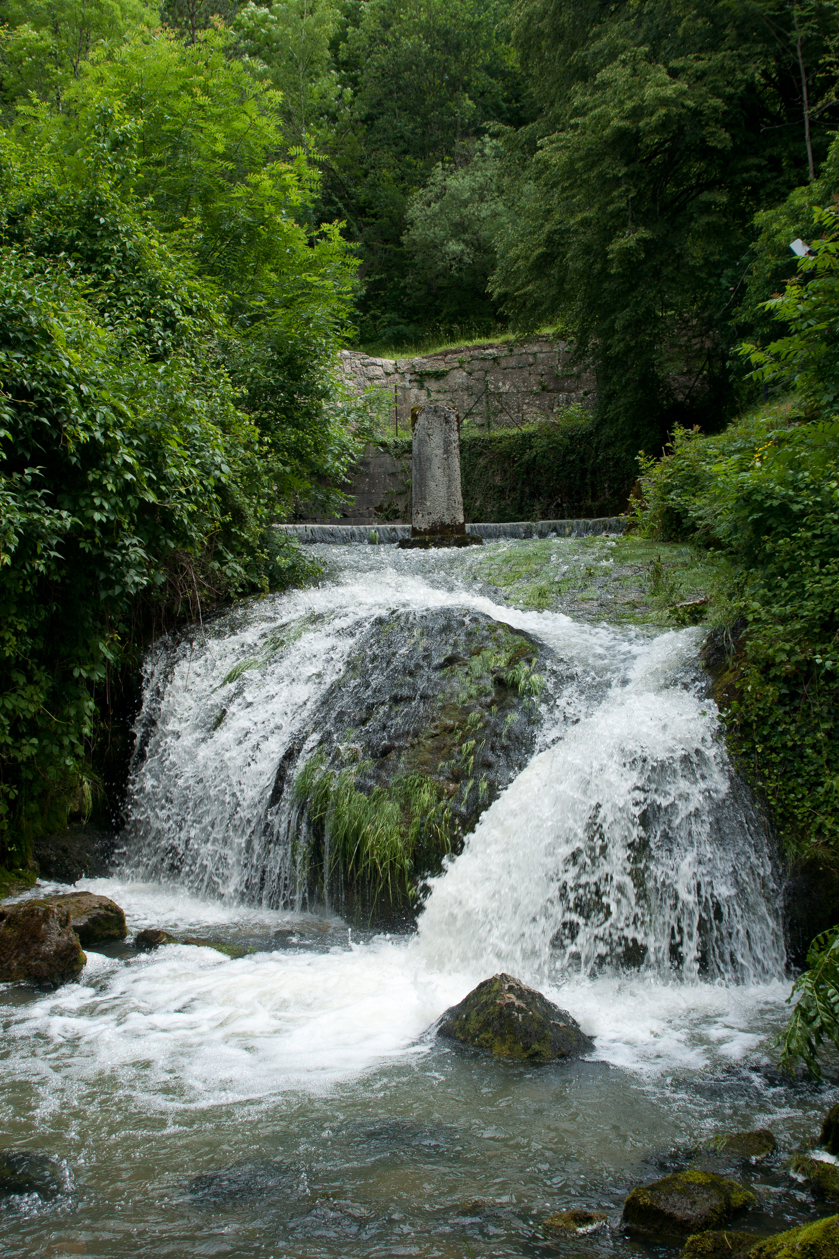
What is it?
- Name: Source de la Doye
- Type: Natural spring (💧)
- Location: Nantua, Rhône‑Alpes, France
- Coordinates: 46.148640 N, 5.641386 E
The spring marks the origin of the Doye River, a tributary that eventually joins the larger Rhône watershed. While the exact height and altitude of the source remain undocumented, the surrounding terrain sits at the edge of the Jura’s limestone plateau, offering a rugged yet accessible landscape.
Historical & Cultural Significance
The Doye valley has long been a corridor for local shepherds, millers, and travelers who relied on its clear waters for drinking, irrigation, and powering small watermills. Though the spring itself isn’t a major historic monument, its presence shaped the settlement patterns of Nantua and the surrounding communes. The name “Doye” appears in medieval charters, indicating the watercourse’s importance to the region’s early economy.
Why It Matters to Travelers
- Pure Alpine water: The spring’s water is renowned for its mineral balance and crisp taste—perfect for a refreshing sip after a hike.
- Ecological haven: The surrounding mixed forest is home to a variety of flora and fauna, including orchids, salamanders, and occasional deer sightings.
- Photography gold: The interplay of light on the water, the mossy stones, and the distant Jura peaks creates a picture‑perfect setting for Instagram‑ready shots.
3. How to Get There
By Air
The nearest major airports are Lyon–Saint‑Exupéry (LYS) (≈130 km) and Geneva International Airport (GVA) (≈120 km). From either airport, rent a car and follow the A42 motorway toward Nantua.
By Train
- Lyon to Bourg-en-Bresse: Regular TER (regional) trains run from Lyon Part‑Dieu to Bourg-en-Bresse (≈1 h 15 min).
- Bourg-en-Bresse to Nantua: Transfer to a local TER line that reaches Nantua (≈30 min).
From the Nantua train station, the spring is a short drive or a moderate hike away.
By Car
- From Lyon: Take the A42 east toward Bourg-en-Bresse, then exit onto D1075 toward Nantua. Follow the signs for Route de la Doye.
- From Geneva: Head north on the A40, then take the A42 east to Nantua.
Parking is available at the Nantua visitor centre (Parking du Lac), a 10‑minute walk to the trailhead.
By Public Bus
The Région Auvergne‑Rhône‑Alpes (RTRA) bus line 31 connects Bourg-en-Bresse to Nantua on weekdays. Check the latest timetable on the Région Auvergne‑Rhône‑Alpes transport website before you travel.
Walking / Hiking
If you enjoy hiking, the GR 9 long‑distance trail passes near the spring. From the town centre, follow the sentier balisé (marked trail) heading north toward the Doye source. The walk is roughly 2 km and takes about 45 minutes on moderate terrain.
4. Best Time to Visit
| Season | Weather | Highlights |
|---|---|---|
| Spring (April‑June) | Mild temperatures (10‑20 °C), blooming wildflowers | Ideal for photography; water flow is strong from snow melt. |
| Summer (July‑August) | Warm, occasional thunderstorms | Perfect for a cool drink at the spring; longer daylight for extended hikes. |
| Autumn (September‑October) | Crisp air, golden foliage | Quiet visitor numbers; excellent for bird‑watching. |
| Winter (November‑March) | Cold, possible snow on higher trails | The spring may be partially frozen—still beautiful, but limited access. |
Top recommendation: Late May to early June offers the best combination of comfortable weather, vibrant flora, and robust water flow, making it the prime season for first‑time visitors.
5. What to Expect
The Senses
- Sight: Crystal‑clear water bubbling from a stone‑lined basin, framed by moss‑covered rocks and towering beech trees. In spring, the surrounding meadow bursts with yellow‑crowned buttercups and purple lupines.
- Sound: A gentle, continuous murmur of water, punctuated by the occasional call of a chaffinch or the rustle of a squirrel in the canopy.
- Touch: The cool, mineral‑rich water is refreshing to the skin—feel free to dip your hands or even your feet, respecting any local signage.
- Smell: Fresh, earthy aromas of damp leaf litter and pine needles, especially after a light rain.
Trail Experience
The path to the spring is well‑maintained, with wooden boardwalk sections that protect the delicate riparian zone. Signage in French provides brief information about the Doye river’s ecology. The hike is moderately easy, suitable for families, senior travelers, and casual walkers. Expect a gentle ascent of 150 m over the 2 km route.
Facilities
- Restrooms: Portable eco‑toilets near the parking lot (seasonally serviced).
- Picnic area: A small clearing with benches and a waste‑recycling station, ideal for a snack break.
- Information board: Details about the spring’s geology and local wildlife (in French and English).
6. Nearby Attractions
While the Source de la Doye is the star of the day, the surrounding Rhône‑Alpes region offers several complementary points of interest within a short radius. All are reachable by foot or a brief drive.
| Attraction | Type | Distance from Source de la Doye | Highlights |
|---|---|---|---|
| Unnamed Spring | Spring | 1.5 km | A quiet secondary spring, perfect for a short side‑trip. |
| Local Fountain | Fountain | 1.7 km | Traditional stone fountain in a nearby hamlet; great for a cultural pause. |
| Waterfall | Waterfall | 2.3 km | A modest cascade surrounded by ferns; ideal for a photo stop. |
| Second Spring | Spring | 2.3 km | Another pristine water source, offering a comparative view of the region’s hydro‑geology. |
| Historic Fountain | Fountain | 2.6 km | Features historic stonework dating back to the 19th century. |
Tip: Because these sites are not officially marked on major tourist maps, ask the local Nantua tourist office for a printed trail guide or GPS waypoints.
7. Travel Tips
| Tip | Details |
|---|---|
| Bring proper footwear | Even though the trail is easy, sections can be slippery after rain. Waterproof hiking boots or sturdy trail shoes are recommended. |
| Pack a reusable water bottle | While the spring water is drinkable, carrying a bottle helps you stay hydrated on the walk and reduces plastic waste. |
| Check weather forecasts | The Jura can experience sudden thunderstorms in summer; a lightweight rain jacket is essential. |
| Respect the environment | Stay on marked paths, avoid picking plants, and pack out any litter. The spring’s ecosystem is fragile. |
| Language | French is the primary language. Basic phrases like “Bonjour”, “Où est la source de la Doye?” and “Merci” go a long way. |
| Currency | Euro (€). Small cash is useful for local cafés or the visitor centre, though most places accept cards. |
| Safety | Mobile coverage is generally good, but a physical map is advisable in remote sections. |
| Photography | Early morning light (sunrise around 8:30 am in summer) offers the softest illumination on the water. |
| Nearby dining | The town of Nantua has several cafés serving regional specialties such as quenelles de brochet (pike dumplings) and comté cheese. |
Final Thoughts
The Source de la Doye may not have the fame of the Gorges du Verdon or the lavender fields of Provence, but its quiet allure captures the essence of Rhône‑Alpes: pure water, verdant forests, and a welcoming local culture. Whether you’re a seasoned hiker, a family on a weekend getaway, or a photographer hunting for that perfect natural frame, this spring offers a genuine slice of French Alpine serenity.
Pack your boots, follow the GPS coordinates 46.148640, 5.641386, and let the gentle flow of the Doye guide you into one of the most peaceful corners of France. Happy travels!