Barrage des Plats – A Hidden Gem in Rhône‑Alpes, France
Discover the serene beauty of this historic dam, the surrounding Alpine landscape, and the charming villages that make Saint‑Genest‑Malifaux a perfect off‑the‑beaten‑path destination.
Introduction
If you think France’s most famous sights are limited to Eiffel Tower selfies and Provençal lavender fields, think again. Tucked away in the rolling hills of Rhône‑Alpes, the Barrage des Plats (also known as the Sapt Dam) offers a tranquil escape for travelers who crave nature, engineering marvels, and authentic French countryside charm. Whether you’re an avid photographer, a cycling enthusiast, or simply someone who loves a quiet spot to reflect by the water, this modest dam delivers a surprisingly rich experience—without the crowds.
About Barrage des Plats
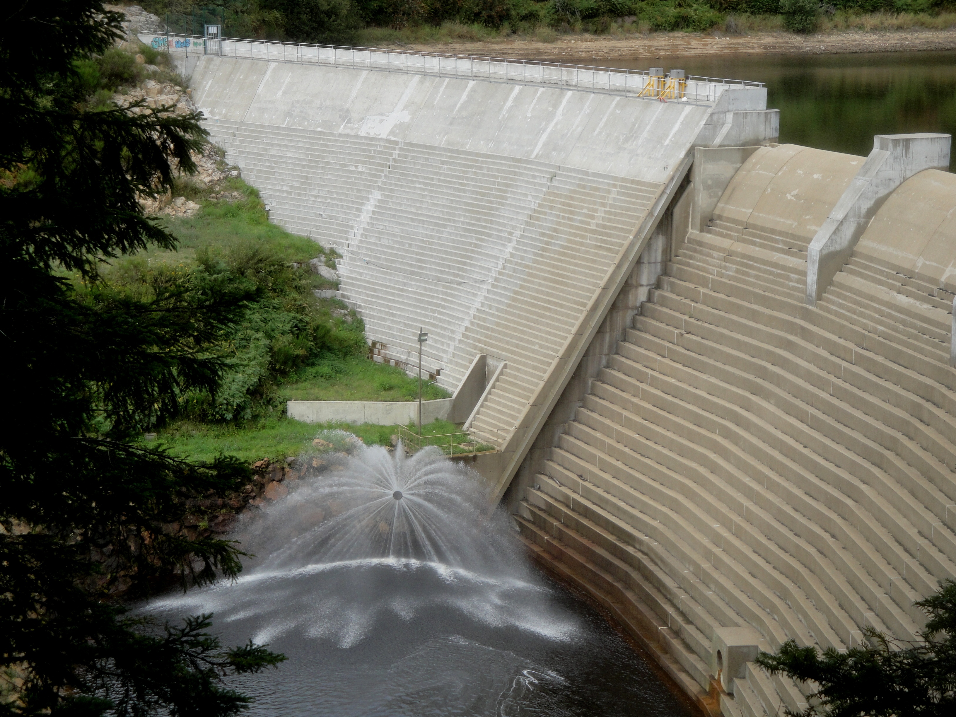
A Brief History
Built in the early 20th century as part of a regional effort to harness the Loire‑Sapt river’s hydro‑power potential, the Barrage des Plats has served both functional and recreational roles for over a century. While the exact height and altitude of the structure remain undocumented, its sturdy concrete arches and spillway reflect the classic engineering style of French dams from that era.
The dam’s name, des Plats, translates roughly to “of the flat lands,” a nod to the gently undulating plateau that surrounds the reservoir. Over the decades, the water body created by the dam has become a habitat for native fish species and a stop‑over for migratory birds, adding ecological value to its industrial purpose.
Why It Matters
- Hydro‑electric heritage – The dam contributed to the early electrification of nearby towns such as Saint‑Genest‑Malifaux and Saint‑Étienne.
- Scenic backdrop – The reservoir mirrors the surrounding pine‑clad hills, making it a favorite spot for landscape photographers.
- Gateway to outdoor activities – Hiking, mountain biking, and gentle kayaking are popular ways to explore the area.
Because it sits in a relatively remote part of Rhône‑Alpes, the Barrage des Plats remains a peaceful alternative to the more tourist‑heavy Alpine lakes further east.
How to Get There
By Air
- Lyon–Saint‑Exupéry Airport (LYS) – The largest international gateway in the region, about 80 km (≈ 1 hour) north‑east of the dam.
- Grenoble Alpes–Isère Airport (GNB) – A smaller option, roughly 120 km (≈ 1 hour 45 min) south‑east.
From either airport, rent a car and follow the A47 motorway toward Saint‑Étienne, then take the D1089 and D1085 local roads that wind through the forested valleys to Saint‑Genest‑Malifaux.
By Train
- Lyon Part‑Dieu and Saint‑Étienne Châteaucreux are the main rail hubs.
- From Saint‑Étienne, catch a regional TER train to Le Puy‑en‑Velay (the nearest station, about 15 km away).
- A short taxi ride or local bus (line 12) will bring you to the dam’s parking area.
By Car
- From Lyon: Take the A47 → exit for Saint‑Étienne → follow signs for Le Puy‑en‑Velay → D1089 → D1085 → Barrage des Plats (coordinates 45.331526, 4.407063).
- From Saint‑Étienne: Head south on the N89, then turn onto D1089 and D1085. The route is well‑marked and offers scenic viewpoints along the way.
Parking: A modest, free parking lot sits near the dam’s visitor area. Spaces fill up quickly in summer, so arrive early if you plan to explore the trails.
Best Time to Visit
| Season | Weather | Why Visit |
|---|---|---|
| Spring (April–June) | Mild temperatures (12‑20 °C), blooming wildflowers | Ideal for hiking and photography; water levels are high, perfect for kayaking. |
| Summer (July–August) | Warm (20‑28 °C), occasional thunderstorms | Longer daylight hours for extended trail walks; great for picnics by the reservoir. |
| Autumn (September–October) | Cool, crisp air (10‑18 °C), golden foliage | Fewer visitors, vibrant colors, excellent for bird‑watching. |
| Winter (November–March) | Cold, occasional snow | The dam takes on a dramatic, icy silhouette—perfect for atmospheric shots, but many trails may be icy. |
Tip: The dam’s spillway is most impressive after a heavy rain in late spring, when the water rushes over the concrete crest, creating a spectacular misty display.
What to Expect
Scenic Views
From the main observation platform, you’ll see the reservoir stretching across a shallow valley, framed by pine forests and distant limestone ridges. On clear days, you can even glimpse the silhouette of the Mont Pilat range to the west.
Walking & Cycling Trails
- Le Sentier du Sapt – A 4‑km loop that follows the river upstream, offering interpretive panels about the dam’s construction and local flora.
- Cycle Route 12 – Part of the Rhône‑Alpes bike network, this paved path connects the dam with the nearby village of Saint‑Genest‑Malifaux and the historic Barrage de Cotatay (5.6 km away).
Both routes are moderate in difficulty, suitable for families and casual hikers.
Wildlife
The reservoir’s calm waters attract ducks, herons, and occasionally kingfishers. In early spring, you may spot migratory swallows nesting along the dam’s concrete edges.
Picnic Spots
Designated grassy areas near the water’s edge provide a perfect setting for a French‑style picnic. Pack a baguette, cheese, and a bottle of local Côtes du Rhône for an authentic experience.
Safety
While the dam itself is not open for climbing, safety railings and clear signage keep visitors away from restricted zones. Follow posted guidelines, especially if you decide to kayak—only small, non‑motorized vessels are permitted.
Nearby Attractions
Exploring the Barrage des Plats region gives you a chance to discover several charming natural sites within a short drive:
| Attraction | Distance | Type | Quick Link |
|---|---|---|---|
| Fountain of La Source | 4.1 km | Fountain | Visit Fountain of La Source |
| Source de la Font Ria | 4.4 km | Fountain | Explore Source de la Font Ria |
| Local Spring (Unnamed) | 5.4 km | Spring | Discover the Spring |
| Barrage de Cotatay | 5.6 km | Dam | Barrage de Cotatay Details |
| Another Local Spring | 6.0 km | Spring | Spring Spot Info |
All attractions are accessible via the same D1085 road that leads to the dam, making it easy to combine them into a single day itinerary.
Travel Tips
- Bring sturdy walking shoes – The trails can be uneven, especially after rain.
- Pack a reusable water bottle – There are refill stations at the visitor kiosk.
- Check dam opening hours – The site is generally open year‑round from 9 am to sunset, but seasonal maintenance may affect access.
- Respect wildlife – Keep a respectful distance from nesting birds and avoid feeding the fish.
- Cash for local vendors – Small cafés and farm stands in Saint‑Genest‑Malifaux often prefer cash.
- Weather watch – If you plan to kayak, verify water levels and weather conditions with the local tourist office (office hours 8 am–5 pm).
- Photography gear – A wide‑angle lens captures the sweeping reservoir, while a telephoto lens works well for bird‑watching shots.
Final Thoughts
The Barrage des Plats may not have the fame of the French Riviera or the Alps, but its quiet charm, historic significance, and surrounding natural beauty make it a rewarding destination for the curious traveler. Combine a visit with nearby fountains, springs, and the sister Barrage de Cotatay, and you’ll experience a slice of Rhône‑Alpes that feels both timeless and refreshingly off the tourist radar.
Pack your sense of adventure, a camera, and a hearty appetite for French countryside cuisine—Barrage des Plats is waiting to be discovered.
Happy travels!