Ruines du Barrage de Malpasset – A hauntingly beautiful relic in Provence‑Alpes‑Côte d’Azur
Discover the story, the scenery, and the practicalities of visiting one of France’s most dramatic dam ruins.
1. Introduction
Imagine standing on a silent concrete wall that once held back a torrent of water, now cracked, overgrown, and whispering tales of engineering triumph and tragedy. The Ruines du Barrage de Malpasset (the ruins of the Malpasset Dam) sit on the edge of the Verdon River near the charming village of Bagnols-en‑Foret, in the sun‑kissed region of Provence‑Alpes‑Côte d’Azur.
A day trip to this site feels like stepping onto a living history set: the stark geometry of the broken dam contrasts with the lush Mediterranean vegetation, while the distant mountains frame the scene like a natural amphitheatre. Whether you’re a history buff, a photography enthusiast, or simply a traveler looking for an off‑the‑beaten‑path adventure, the Malpasset dam ruins offer a powerful mix of drama, reflection, and breathtaking landscape.
2. About Ruines du Barrage de Malpasset
History in a nutshell
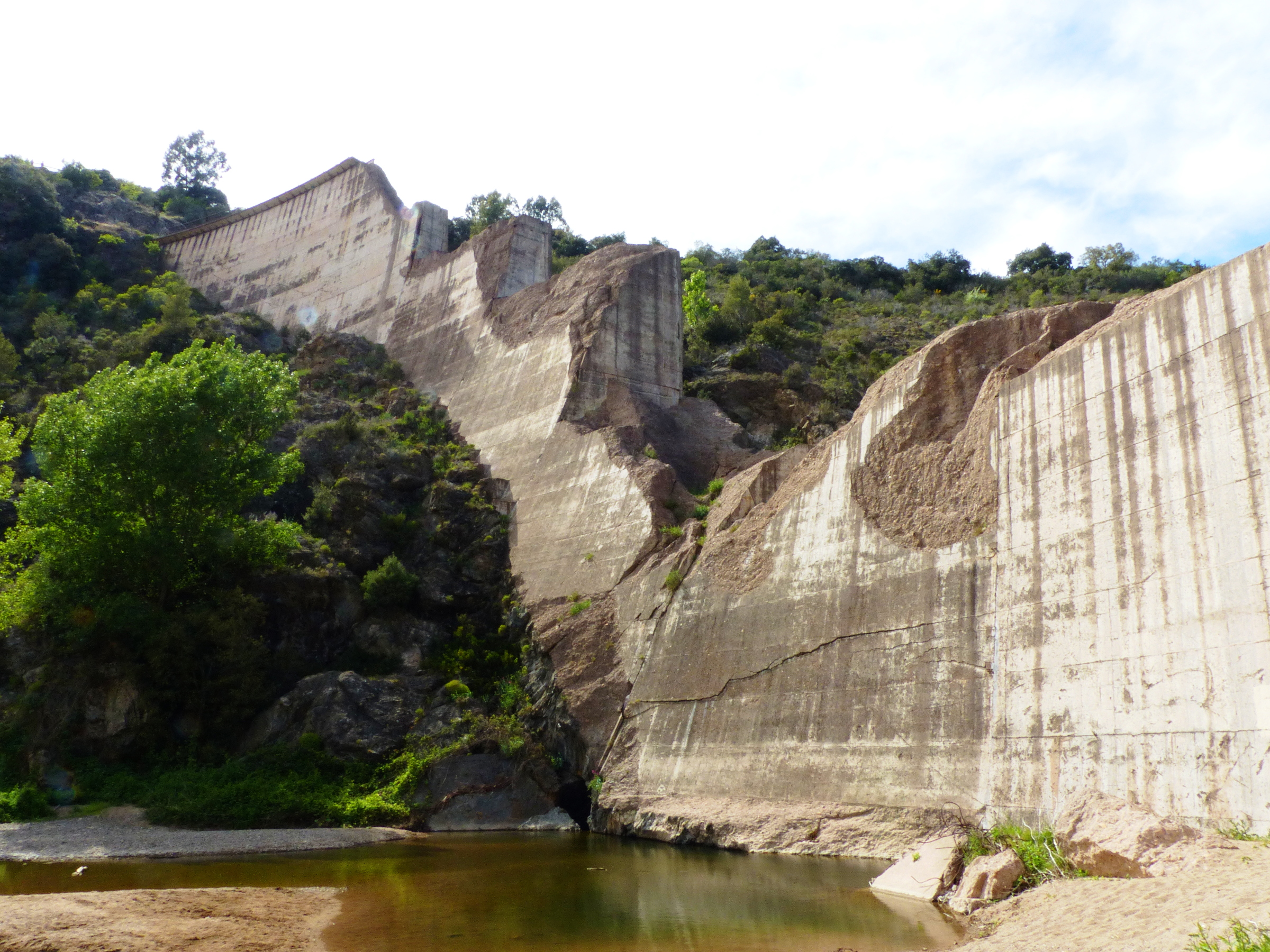
Built in the early 1950s, the Barrage de Malpasset was a concrete arch dam designed to regulate water flow for irrigation, hydro‑electric power, and flood control in the Verdon valley. On December 2 1959, a catastrophic failure caused the dam to collapse, releasing a massive flood that devastated the downstream town of Fréjus and claimed 423 lives. The disaster remains one of the worst dam failures in modern European history.
Today, the remaining concrete arches and spillway fragments stand as a solemn memorial to the lives lost and a reminder of the importance of rigorous engineering standards. The site is protected, and while it is not an active tourist attraction with guided tours, it is freely accessible for visitors who respect the safety signs and stay on designated paths.
Why it matters
- Engineering legacy – The Malpasset disaster reshaped dam safety protocols worldwide. Visiting the ruins gives you a tangible sense of the scale of the structure and the engineering challenges of the era.
- Cultural memory – A small plaque near the site explains the tragedy in French, honoring the victims and the rescue workers.
- Scenic backdrop – The ruins sit against the dramatic limestone cliffs of the Verdon, offering spectacular photo opportunities at sunrise and sunset.
For a deeper dive, the French‑language Wikipedia page provides a comprehensive overview: Barrage de Malpasset (fr).
3. How to Get There
By car
The most convenient way to reach the Ruines du Barrage de Malpasset is by rental car or your own vehicle. From Nice Côte d’Azur Airport (about 120 km away), follow the A8 motorway east toward Cannes, then take the A51 toward Manosque. Exit at Bagnols-en‑Foret (Exit 9) and follow the D 907 road north for roughly 5 km. Look for signs pointing to the “Barrage de Malpasset” parking area.
- Driving time: ~2 hours from Nice, ~1 hour 30 minutes from Marseille.
- Parking: A small, free lot sits near the entrance to the site. Spaces fill quickly in summer, so arrive early.
By public transport
- Train: Take a TER (regional) train from Marseille Saint‑Charles to Manosque‑Les Lauzes (≈1 hour 15 minutes).
- Bus: From Manosque, the local bus line L‑21 runs toward Bagnols‑en‑Foret; get off at the “Bagnols‑en‑Foret – Barrage de Malpasset” stop (check the latest schedule as services are limited on weekends).
- Taxi/ride‑share: A short 10‑minute taxi ride from the Manosque station will drop you at the dam’s parking area.
By bike or hike
For the adventurous, the Verdon Regional Natural Park offers marked cycling routes that pass near the dam. The terrain is hilly, so a mountain bike with good brakes is recommended.
4. Best Time to Visit
| Season | Weather | Visitor density | Why it’s ideal |
|---|---|---|---|
| Spring (March‑May) | Mild (12‑20 °C), occasional rain | Low to moderate | Wildflowers bloom, fewer crowds, perfect for photography. |
| Summer (June‑August) | Warm to hot (25‑35 °C) | High | Long daylight hours; best for sunrise/sunset shots, but bring water and sun protection. |
| Autumn (September‑November) | Pleasant (15‑25 °C), crisp evenings | Moderate | Golden light, comfortable hiking temps, and the foliage adds color. |
| Winter (December‑February) | Cool (5‑12 °C), occasional frost | Very low | Quietest period; the dam’s stark silhouette against a misty sky can be dramatic, but check road conditions. |
Recommendation: Late spring (mid‑April to early May) or early autumn (late September) provide the best balance of weather, light, and manageable crowds.
5. What to Expect
The visual experience
Approaching the site, you’ll first notice the massive concrete arches—once part of a 195‑meter‑long structure—now broken in places, with vines creeping through the cracks. The Verdon River runs quietly below, its turquoise water a stark contrast to the gray stone. From the main viewpoint, you can see the Barrage de Malpasset spanning the gorge, framed by the limestone cliffs of the Alpes de Haute‑Provence.
Photography highlights
- Sunrise over the dam – The early light paints the concrete gold, and the river reflects the colors.
- Close‑up textures – Capture the weathered concrete, rusted rebar, and mossy patches.
- Panoramic vistas – Use a wide‑angle lens to include the surrounding hills and the distant town of Bagnols‑en‑Foret.
Safety and accessibility
The site is open year‑round, but the terrain can be uneven. Sturdy walking shoes are a must. Some sections of the ruin are fenced off for safety; respect the barriers. There are no restroom facilities on site, so plan accordingly.
6. Nearby Attractions
While the Ruines du Barrage de Malpasset can easily fill a half‑day, the surrounding area offers several points of interest within a short drive:
| Distance | Attraction | Type | Quick link |
|---|---|---|---|
| 0 km | Barrage de Malpasset (the dam itself) | Dam | Barrage de Malpasset (fr) |
| 4.2 km | Unnamed Fountain | Fountain | [Fountain]() |
| 4.6 km | Unnamed Dam | Dam | [Dam]() |
| 4.7 km | Unnamed Fountain | Fountain | [Fountain]() |
| 4.9 km | Unnamed Fountain | Fountain | [Fountain]() |
Tip: The small fountains and dam scattered around the Verdon valley are often tucked into villages or countryside lanes. A quick stop for a coffee at a local café nearby can turn a brief detour into a charming cultural pause.
7. Travel Tips
| Tip | Details |
|---|---|
| Check weather forecasts | The Verdon gorge can experience sudden fog or thunderstorms, especially in spring. |
| Bring water and snacks | No vending machines or cafés at the ruin itself. |
| Dress in layers | Temperatures shift quickly from the valley floor to higher viewpoints. |
| Respect the site | Stay on marked paths, do not climb on unstable concrete, and carry out any litter. |
| Photography gear | A tripod is handy for low‑light sunrise shots; a polarizing filter can reduce glare on the water. |
| Local cuisine | After your visit, head to Bagnols‑en‑Foret for Provençal specialties like ratatouille, socca, and local rosé. |
| Language | Signage is primarily in French; a basic phrasebook or translation app will be useful. |
| Parking | Arrive early in summer to secure a spot; the lot fills up by 10 am. |
| Safety | The area around the dam is uneven; watch your step, especially after rain. |
| Connectivity | Mobile signal can be spotty; download offline maps (e.g., Google Maps offline area) before you go. |
Final thoughts
The Ruines du Barrage de Malpasset is more than a relic of engineering; it’s a poignant reminder of nature’s power, human ambition, and the resilience of the Provençal landscape. A visit offers a blend of history, photography, and the raw beauty that defines Provence‑Alpes‑Côte d’Azur. Pack your camera, respect the site, and let the silent arches tell you their story. Safe travels!