Barrage de Thuriès – A Hidden Gem in Midi‑Pyrénées
Discover the quiet charm of a 30‑meter‑high dam nestled in the rolling hills of Mirandol‑Bourgnounac, and explore the natural wonders that surround it.
Introduction
If you think the French countryside is only about vineyards, lavender fields, and medieval towns, think again. Tucked away in the heart of the Midi‑Pyrénées region lies Barrage de Thuriès, a modest yet striking dam that offers a perfect blend of engineering intrigue, serene water‑scapes, and easy access to a cluster of waterfalls and weirs. Whether you’re a road‑trip enthusiast, a photography lover, or simply someone looking for a peaceful spot to unwind, this dam is a surprisingly rewarding stop on any itinerary through southern France.
About Barrage de Thuriès
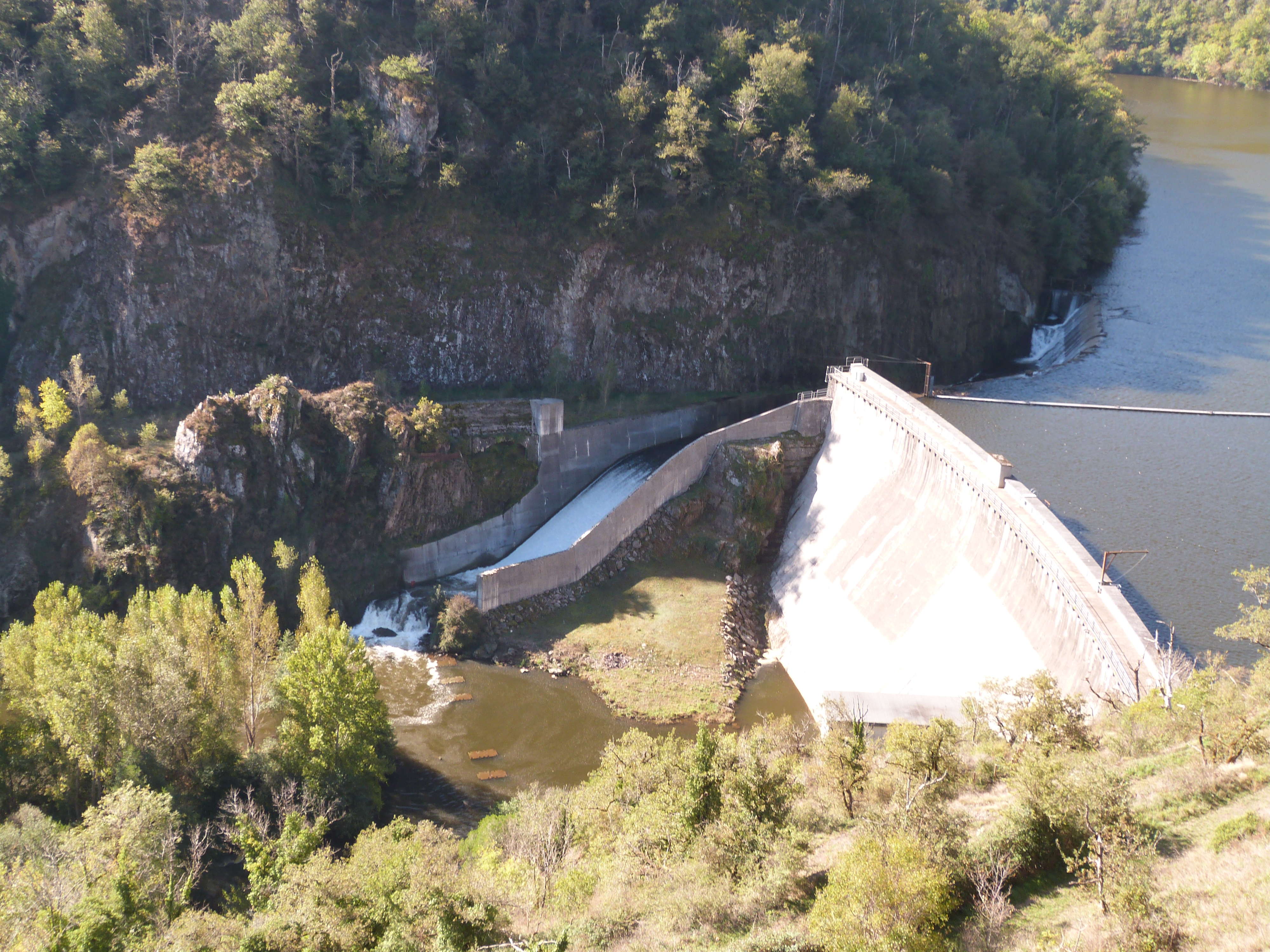
- Type: Dam 🏗️
- Location: Mirandol‑Bourgnounac, Midi‑Pyrénées, France
- Coordinates: 44.123559 N, 2.255328 E
- Height: 30.7 m
Barrage de Thuriès was built to regulate the flow of the local waterways and support regional water management. Though its altitude isn’t publicly documented, the dam’s 30.7‑meter height makes it a noticeable landmark against the gentle, undulating terrain of the Occitanie countryside.
The structure is more than a functional piece of infrastructure; it represents the harmonious relationship between human ingenuity and the natural environment that characterises many French water projects. Its concrete face reflects the sky, while the surrounding forested banks provide a lush backdrop—making it an ideal spot for casual walks, bird‑watching, and low‑key photography.
For a deeper dive into the dam’s history and technical details, you can consult the French‑language Wikipedia entry: Barrage de Thuriès (fr.wikipedia.org).
How to Get There
By Car
The most convenient way to reach Barrage de Thuriès is by car. From Albi, a major city in the region, follow the D119 road south‑east for roughly 30 km until you arrive at the village of Mirandol‑Bourgnounac. Signage for the dam is minimal, but a quick glance at the GPS coordinates (44.123559, 2.255328) will guide you onto a small, well‑maintained rural lane that leads directly to the water’s edge.
Public Transport
Public transport options are limited. The nearest train station is in Albi, served by TER Occitanie regional trains. From there, you can catch a local bus to Mirandol‑Bourgnounac (bus line 102 runs a few times a day). Once in town, a short 10‑minute walk or a quick taxi ride will bring you to the dam.
Parking & Accessibility
A modest parking area sits just a few meters from the dam’s viewing platform. The site is flat and wheelchair‑friendly, though the surrounding paths can be uneven in wet weather, so sturdy walking shoes are recommended.
Best Time to Visit
| Season | Highlights | Weather Tips |
|---|---|---|
| Spring (Mar‑May) | Fresh greenery, blooming wildflowers, and higher water flow that creates gentle ripples. | Temperatures 12‑18 °C; bring a light jacket. |
| Summer (Jun‑Aug) | Long daylight hours perfect for sunrise or sunset shots; nearby waterfalls are at their fullest. | Warm (20‑28 °C); stay hydrated, especially if hiking. |
| Autumn (Sep‑Nov) | Golden foliage, quieter visitor numbers, and crisp air ideal for photography. | Mild (13‑20 °C); a windproof layer helps. |
| Winter (Dec‑Feb) | Calm, glass‑like surface on the reservoir; occasional frost adds a magical feel. | Cooler (5‑10 °C); dress in layers, watch for icy paths. |
Overall, late spring to early autumn offers the most comfortable conditions for outdoor activities, while winter provides a tranquil, off‑peak experience for those who enjoy solitude.
What to Expect
When you arrive at Barrage de Thuriès, you’ll be greeted by a still, reflective reservoir framed by low hills and scattered oak groves. The dam’s concrete crest stretches across the water, creating a subtle contrast between man‑made structure and natural landscape.
- Scenic Walks: A short loop trail circles the reservoir, offering multiple viewpoints. Stop at the wooden bench near the western edge for a panoramic view of the dam against the distant Cévennes foothills.
- Photography: Early morning light casts soft hues across the water, while late afternoon sun creates dramatic shadows on the dam’s face. The nearby Pampelonne waterfall (0.7 km away) adds a cascading element to your photo series.
- Birdwatching: The reservoir attracts ducks, herons, and occasional kingfishers. Bring binoculars for a closer look.
- Picnicking: Designated grassy spots near the parking area are perfect for a relaxed lunch. Remember to pack out any waste to preserve the pristine environment.
The atmosphere is generally calm, with only the gentle hum of water flowing through the spillways. No commercial facilities (shops, cafés) are located directly at the dam, so plan ahead for food and drinks.
Nearby Attractions
The dam serves as a convenient hub for exploring several natural attractions within a 5‑km radius. Each spot is reachable on foot or by a short bike ride.
| Attraction | Distance | Type | Quick Link |
|---|---|---|---|
| Unnamed Weir | 0.6 km | Weir | Weir (0.6 km) |
| Pampelonne Waterfall | 0.7 km | Waterfall | Pampelonne Waterfall |
| Unnamed Weir | 2.5 km | Weir | Weir (2.5 km) |
| Unnamed Weir | 3.6 km | Weir | Weir (3.6 km) |
| Unnamed Waterfall | 4.1 km | Waterfall | Waterfall (4.1 km) |
Tip: The cluster of weirs and waterfalls creates a natural “water trail” that’s perfect for a leisurely hike. Bring a waterproof camera bag—splashes are inevitable near the cascades!
Travel Tips
- Carry Cash: Small rural villages often rely on cash for local cafés or souvenir stalls.
- Stay Connected: Mobile coverage can be spotty near the dam; download offline maps (Google Maps or Maps.me) before you set out.
- Leave No Trace: The area is part of a protected watershed. Pack out all litter and avoid feeding wildlife.
- Timing for Photos: Sunrise (≈ 7:30 am in summer) and sunset (≈ 8:30 pm) provide the most dramatic lighting on the dam’s surface.
- Bike Rental: If you’re staying in Albi or nearby towns, consider renting a bike for a scenic ride to the dam—bike lanes are well‑marked along the D119.
- Safety First: While the water is generally calm, avoid swimming near the spillways and watch out for slippery rocks around the waterfalls.
- Local Events: Check the Mirandol‑Bourgnounac municipal website for occasional festivals or markets that may coincide with your visit.
Wrap‑Up
Barrage de Thuriès may not boast the fame of France’s iconic landmarks, but its quiet allure, combined with the surrounding network of waterfalls and weirs, makes it a must‑see destination for off‑the‑beaten‑path travelers. Whether you’re mapping a road trip through the Midi‑Pyrénées, seeking a peaceful spot for a day of photography, or simply craving a taste of rural French charm, this dam offers a refreshing slice of serenity.
Pack your camera, lace up your walking shoes, and let the gentle flow of Thuriès guide you into the heart of southern France’s hidden natural beauty. Safe travels! 🌿🏞️
