末田須賀堰 (Suita‑Suga Weir) – A Hidden Water‑Works Gem in Kasukabe, Saitama
Discover the quiet charm of a historic weir tucked away in the heart of Saitama’s lush countryside. Perfect for water‑loving travelers, photographers, and anyone seeking a peaceful off‑the‑beaten‑path experience.
1. Introduction
If you think Japan’s natural attractions are limited to towering mountains, bustling city parks, or famous hot springs, think again. Nestled in the suburban city of Kasukabe—just a short train ride north of Tokyo—lies 末田須賀堰 (Suita‑Suga Weir), a modest yet captivating piece of hydraulic engineering that has quietly shaped the local landscape for generations.
While it doesn’t boast the dramatic height of a waterfall or the neon lights of a metropolis, this weir offers a serene riverside setting, subtle seasonal changes, and a glimpse into the region’s water‑management heritage. For travelers who love to wander off the typical tourist trail, 末田須賀堰 is a rewarding stop that combines nature, history, and Japanese rural life in one compact package.
2. About 末田須賀堰
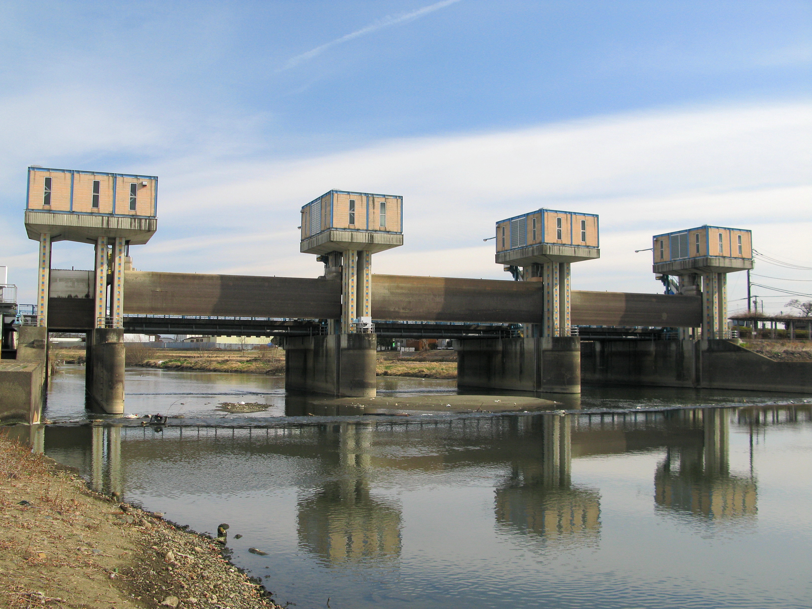
What Is a Weir?
A weir (堰, seki) is a low dam built across a river or stream to regulate water flow, raise the water level for irrigation, or create a stable water source for nearby communities. Unlike large dams, weirs are typically low‑profile structures that blend seamlessly into their surroundings—exactly what you’ll see at 末田須賀堰.
History & Significance
Although specific construction dates for 末田須賀堰 are not publicly documented, its presence is recorded in local archives and on the Japanese Wikipedia page for the site. Historically, weirs like this one have been essential for 農業用水 (agricultural irrigation) in the Kanto plain, supporting rice paddies and vegetable farms that have fed the Tokyo metropolitan area for centuries.
Located at 35.928187° N, 139.737347° E, the weir sits at an altitude that aligns with the gently rolling terrain of Kasukabe. Its modest size makes it an ideal spot for locals to monitor water levels, especially during the rainy season when the Arakawa River system swells.
Why It Matters Today
In an era where water sustainability is a global concern, traditional structures like 末田須賀堰 serve as living examples of low‑impact engineering. The weir continues to play a role in local flood control and water distribution, illustrating how centuries‑old techniques remain relevant. For visitors, it’s a chance to witness a functional piece of Japan’s environmental heritage up close.
3. How to Get There
From Tokyo
| Step | Transport | Approx. Time | Cost |
|---|---|---|---|
| 1 | JR Keihin‑Tohoku Line (Tokyo → Kasukabe) | 30‑35 min | ¥480 |
| 2 | Walk or bike from Kasukabe Station (JR) to the weir | 15‑20 min (walk) / 5‑7 min (bike) | Free / ¥200 bike rental |
Tip: If you prefer a more scenic route, hop on the Tobu Isesaki Line to Kasukabe‑Higashi Station and walk eastward toward the riverbank.
By Car
- From Tokyo: Take the Shuto Expressway (C2) to the Kasukabe‑IC exit, then follow local signs for Kasukabe‑City Hall and head toward the Suita‑Suga area.
- Parking: Limited street parking is available near the river; arrive early on weekends to secure a spot.
By Bicycle
Kasukabe is known for its bike‑friendly streets. Rent a city bike from the Kasukabe City Hall rental desk (¥300/day) and follow the Arakawa River Cycle Path northward—signage will guide you to the weir.
4. Best Time to Visit
| Season | Highlights | Photography Tips |
|---|---|---|
| Spring (Mar‑May) | Cherry blossoms line the riverbank; water levels rise gently. | Early morning light (sunrise) brings soft pastel tones. |
| Summer (Jun‑Aug) | Lush green foliage; occasional fireflies after dusk. | Use a polarizing filter to reduce glare on the water surface. |
| Autumn (Sep‑Nov) | Brilliant maple and ginkgo leaves reflect in the calm water. | Capture reflections at low tide for dramatic symmetry. |
| Winter (Dec‑Feb) | Bare branches create a minimalist landscape; occasional frost on the weir. | Shoot in the blue hour for cool, crisp tones. |
Overall recommendation: Late April to early May offers the perfect blend of mild weather, blooming flora, and moderate visitor numbers, making it the most Instagram‑friendly period.
5. What to Expect
The Setting
Approaching 末田須賀堰, you’ll first notice a gently curving river flanked by grass‑covered embankments and scattered willow trees. The weir itself is a low stone structure, partially covered in moss—a subtle reminder of its age. Water flows over a series of small steps, creating a soft, continuous murmur that soothes the senses.
Activities
- Stroll & Picnic: The riverbank provides a flat, grassy area ideal for a quiet lunch.
- Birdwatching: Look out for Japanese white‑eyed ducks and kingfishers that frequent the shallow pools.
- Photography: The weir’s geometry—especially the overflow channels—creates natural leading lines perfect for composition.
- Local Insight: Occasionally, a nearby farmer will be seen checking water gates, offering a chance to learn about traditional irrigation practices.
Facilities
- Restrooms: Small public toilets are located near the Kasukabe City Hall park, a 10‑minute walk away.
- Information Board: A bilingual (Japanese/English) sign explains the weir’s purpose and basic history.
6. Nearby Attractions
While 末田須賀堰 is the star of the day, the surrounding area offers several complementary sights within a short radius:
-
末田大用水取水口 (Suita‑Ōyōsui Water Intake) – Just 0.1 km away, this small weir provides a glimpse into the region’s extensive water‑distribution network.
-
尾ヶ崎新田堰 (Ogasaki‑Shinden Weir) – Approximately 2.7 km south, a larger historic weir surrounded by cherry‑tree groves, perfect for a leisurely hike.
-
Local Fountain (Unnamed) – 3.6 km away, a charming community fountain located in a small park, often used for seasonal festivals.
-
Another Weir (Unnamed) – 3.7 km distance; ideal for water‑engineer enthusiasts interested in comparing design variations.
-
Community Fountain (Unnamed) – 4.7 km away, set in a traditional Japanese garden that showcases seasonal flower displays.
All of these spots are easily reachable by bike or a short bus ride, making it simple to create a half‑day “weir tour” of Kasukabe’s water heritage.
7. Travel Tips
- Bring a Rain Jacket: The region can experience sudden showers, especially during the tsuyu (rainy season) in June.
- Footwear: Wear sturdy, waterproof shoes if you plan to walk along the riverbank—slippery stones are common after rain.
- Timing: Arrive early (7 – 8 AM) to avoid the local school commute and capture the soft morning light.
- Respect the Environment: The weir is a functional piece of infrastructure; avoid climbing on the structure and dispose of trash responsibly.
- Language Help: While most signs are in Japanese, the information board at the weir includes English translations. Having a translation app handy can enhance your understanding of technical terms.
- Connectivity: Mobile signal can be spotty near the river; download offline maps (Google Maps or MAPS.ME) before you go.
Final Thought
In a country renowned for its iconic landmarks, 末田須賀堰 may seem modest, but its quiet elegance and cultural relevance make it a rewarding destination for the curious traveler. Whether you’re a photography enthusiast chasing reflections, a history buff interested in Japan’s water‑management legacy, or simply seeking a peaceful riverside escape from the urban rush, this hidden weir in Kasukabe delivers a memorable experience—one gentle ripple at a time.
Pack your camera, hop on the Keihin‑Tohoku Line, and let the calm flow of 末田須賀堰 wash over you.