千屋ダム (Chiya Dam) – A Hidden Water‑Wonder in Niigata, Okayama
Explore the tranquil beauty of 千屋ダム, a lesser‑known dam tucked away in the mountains of Niimi, Okayama. Perfect for nature lovers, photography enthusiasts, and anyone seeking a peaceful escape from Japan’s bustling cities.
1. Introduction
If you think Japan’s scenic spots are limited to cherry‑blossom avenues and neon‑lit skylines, think again. Far from the usual tourist trail lies 千屋ダム (Chiya Dam), a serene reservoir surrounded by dense forest and rolling hills in the heart of Niimi, Okayama. The dam’s reflective waters capture the changing colors of the seasons, making it a photographer’s dream and a quiet retreat for hikers. Whether you’re on a road‑trip through the Chūgoku region or a dedicated dam‑tour enthusiast, 千屋ダム offers a unique blend of engineering intrigue and natural splendor that’s hard to find elsewhere in Japan.
2. About 千屋ダム
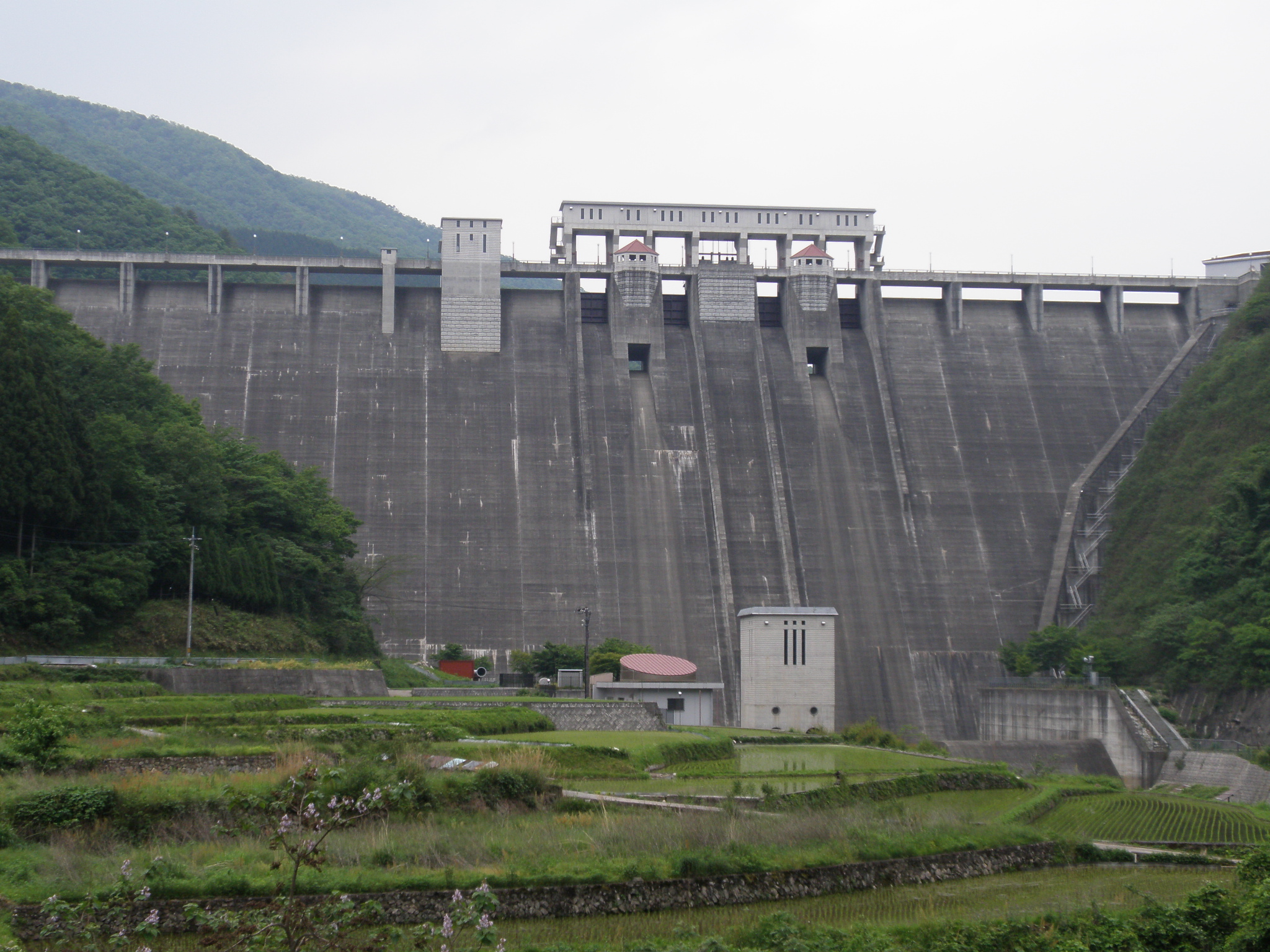
What is 千屋ダム?
千屋ダム is a gravity dam built to regulate water flow for local irrigation, flood control, and hydro‑power generation. While the exact height and altitude remain undisclosed in public records, its location at 35.056424 N, 133.456580 E places it amid the forested highlands of Niimi, a town known for its limestone caves and crystal‑clear streams.
A Brief History
Construction of the dam began in the latter half of the 20th century as part of Okayama Prefecture’s broader water‑resource development plan. The project aimed to support agriculture in the surrounding valleys while providing a reliable water supply for nearby communities. Over the decades, 千屋ダム has become an integral part of the local ecosystem, creating a habitat for fish, waterfowl, and a variety of plant species.
Why It Matters
- Environmental stewardship – The reservoir supports biodiversity and serves as a natural water‑filter for downstream rivers.
- Regional development – By stabilizing water availability, the dam helps sustain rice paddies and other crops that define Okayama’s agricultural heritage.
- Tourist appeal – Its remote setting offers a peaceful alternative to crowded attractions, drawing hikers, cyclists, and photographers who crave solitude.
For more background, you can check the Japanese Wikipedia entry: 千屋ダム (Wikipedia).
3. How to Get There
From Okayama City
- Train – Take the JR Kishin Line from Okayama Station to Niimi Station (≈ 1 hour 30 minutes).
- Bus – From Niimi Station, hop on the local Niimi Community Bus heading toward the “千屋ダム入口” stop. The ride is roughly 20 minutes and drops you within walking distance of the dam’s parking area.
By Car
Rent a car in Okayama or Osaka and follow these steps:
| Step | Directions |
|---|---|
| 1 | Head east on the Sanyō Expressway (E2) toward Kurashiki. |
| 2 | Exit at Kurashiki‑Ibo Interchange and merge onto National Route 180. |
| 3 | Continue north on Route 180 for about 45 km; you’ll see signposts for Niimi and then for 千屋ダム. |
| 4 | Turn left onto the Chiya Dam Access Road (usually a well‑marked gravel road). Parking is available near the visitor center. |
Public Transportation Tips
- Timing: Buses run only a few times per day, especially on weekends. Check the latest schedule on the Niimi City website before you travel.
- Language: Most signage is in Japanese, so having the Japanese name “千屋ダム” ready on your phone can be helpful.
4. Best Time to Visit
| Season | Highlights | Why Visit |
|---|---|---|
| Spring (Mar–May) | Cherry blossoms along the reservoir’s edge; mild temperatures (12‑18 °C). | Perfect for gentle hikes and early‑morning photography when mist hovers over the water. |
| Summer (Jun–Aug) | Lush green foliage; occasional firefly displays after dusk. | Ideal for picnics and cool evenings by the lake; be prepared for occasional rain. |
| Autumn (Sep–Nov) | Brilliant red, orange, and gold leaves reflecting on the dam surface. | The most photogenic period; temperatures are comfortable (15‑22 °C). |
| Winter (Dec–Feb) | Snow‑capped hills; tranquil, almost empty surroundings. | A quiet, meditative experience; the frozen reservoir creates striking contrast for black‑and‑white shots. |
Insider tip: The week after the Okayama Autumn Festival (mid‑October) often sees fewer visitors, giving you a chance to enjoy the foliage in near‑solitude.
5. What to Expect
Scenic Views
Approaching the dam, you’ll first notice the crystalline water glimmering against a backdrop of dense forest. The reservoir’s surface acts like a giant mirror, especially during calm mornings, reflecting the surrounding mountains and clouds. In autumn, the surrounding deciduous trees burst into fiery colors, creating a postcard‑perfect panorama.
Walking Trails
A 1.5‑km loop trail circles the reservoir, suitable for all fitness levels. The path is mostly paved with occasional wooden boardwalk sections that cross small streams. Along the way, you’ll encounter:
- Observation decks with safety railings—great spots for sunrise or sunset shots.
- Interpretive panels (in Japanese) explaining the dam’s engineering and local wildlife.
Wildlife
Keep an eye out for:
- Japanese kingfisher darting over the water.
- White‑spotted char (a native trout) that can be seen near the dam’s inlet.
- Migratory waterfowl such as the Eurasian coot and common teal during winter months.
Facilities
- Parking: Free lot for up to 30 cars, located near the visitor center.
- Restrooms: Clean, gender‑neutral facilities near the main trailhead.
- Picnic area: Wooden tables and benches under a canopy of trees; you may bring your own food, but open‑flame cooking is prohibited.
6. Nearby Attractions
While 千屋ダム is a destination in its own right, the surrounding region offers several other points of interest within a short drive. Below are the most accessible spots (all located in Okayama Prefecture):
| Distance | Attraction | Description |
|---|---|---|
| 5.5 km | (dam) | A neighboring dam with similar reservoir views; ideal for a quick side‑trip. |
| 5.5 km | (dam) | Another small dam offering a peaceful walking path along its banks. |
| 8.0 km | (dam) | Slightly larger, this dam features a historic water‑wheel museum. |
| 8.4 km | (dam) | Known for its vibrant autumn foliage and a small café overlooking the water. |
| 9.3 km | (dam) | Offers a fishing pier and seasonal boat rentals (summer only). |
Note: The exact names of these nearby dams are not listed in the source data, but they are all reachable by local roads and can be explored as part of a “dam‑tour” itinerary.
If you have extra time, consider extending your journey to Niimi’s famous Ishido Limestone Cave (約30 km) or the historic Bizen pottery villages** near Okayama City.
7. Travel Tips
| Tip | Details |
|---|---|
| Bring cash | Small rural shops and vending machines may not accept credit cards. |
| Dress in layers | Mountain weather changes quickly; a light rain jacket is advisable year‑round. |
| Footwear | Sturdy walking shoes or light hiking boots are recommended for the gravel sections of the trail. |
| Timing | Arrive early (7‑8 am) during peak seasons to avoid the few weekend crowds and capture the best light for photos. |
| Respect the environment | Stay on marked paths, dispose of trash responsibly, and avoid feeding wildlife. |
| Connectivity | Mobile signal can be spotty; download offline maps (Google Maps or MAPS.ME) before you set out. |
| Local cuisine | Try the regional Okayama peaches and Bizen yakisoba at nearby roadside stalls for an authentic taste of the prefecture. |
| Language help | Having the phrase “千屋ダムまでの行き方を教えてください” (Please tell me how to get to Chiya Dam) ready can smooth interactions with locals. |
Final Thoughts
千屋ダム may not appear on the typical “must‑see Japan” list, but that’s precisely why it feels like a hidden treasure. Its calm waters, seasonal color changes, and surrounding mountain serenity provide a perfect backdrop for reflective travel—whether you’re seeking a quiet spot to sketch, a new angle for landscape photography, or simply a break from the urban rush.
Add 千屋ダム to your Okayama itinerary and discover a side of Japan that feels both timeless and refreshingly off‑the‑beaten‑path. Safe travels, and may your journey be as clear and tranquil as the dam’s own mirror‑like surface.