フランス式階段流路 – A Hidden Waterfall Gem in Shiojiri, Nagano
Discover the serene charm of フランス式階段流路, a lesser‑known waterfall tucked away in the heart of Nagano’s lush countryside. Whether you’re a seasoned waterfall hunter or a first‑time visitor to Japan’s alpine region, this tranquil spot offers a perfect blend of natural beauty, local history, and off‑the‑beaten‑path adventure.
1. Introduction
Imagine stepping off the bustling streets of Tokyo and finding yourself surrounded by crystal‑clear streams, moss‑covered rocks, and the gentle roar of water cascading down a series of stone steps. That’s the experience awaiting you at フランス式階段流路 (pronounced “Furansu‑shiki Kaidan Ryūro”), a charming waterfall located in Shiojiri, Nagano Prefecture. While it doesn’t boast the towering height of Kegon Falls or the dramatic plunge of Shiraito, its unique “French‑style stair” layout creates a series of delicate mini‑cascades that feel like nature’s own staircase.
For travelers seeking authentic Japanese scenery without the crowds, this waterfall is a hidden treasure that embodies the peaceful rhythm of rural Nagano. In this guide, we’ll explore the waterfall’s background, how to reach it, the best times to visit, what you’ll see on the ground, nearby attractions, and practical tips to make your trip smooth and memorable.
2. About フランス式階段流路
Description & Layout
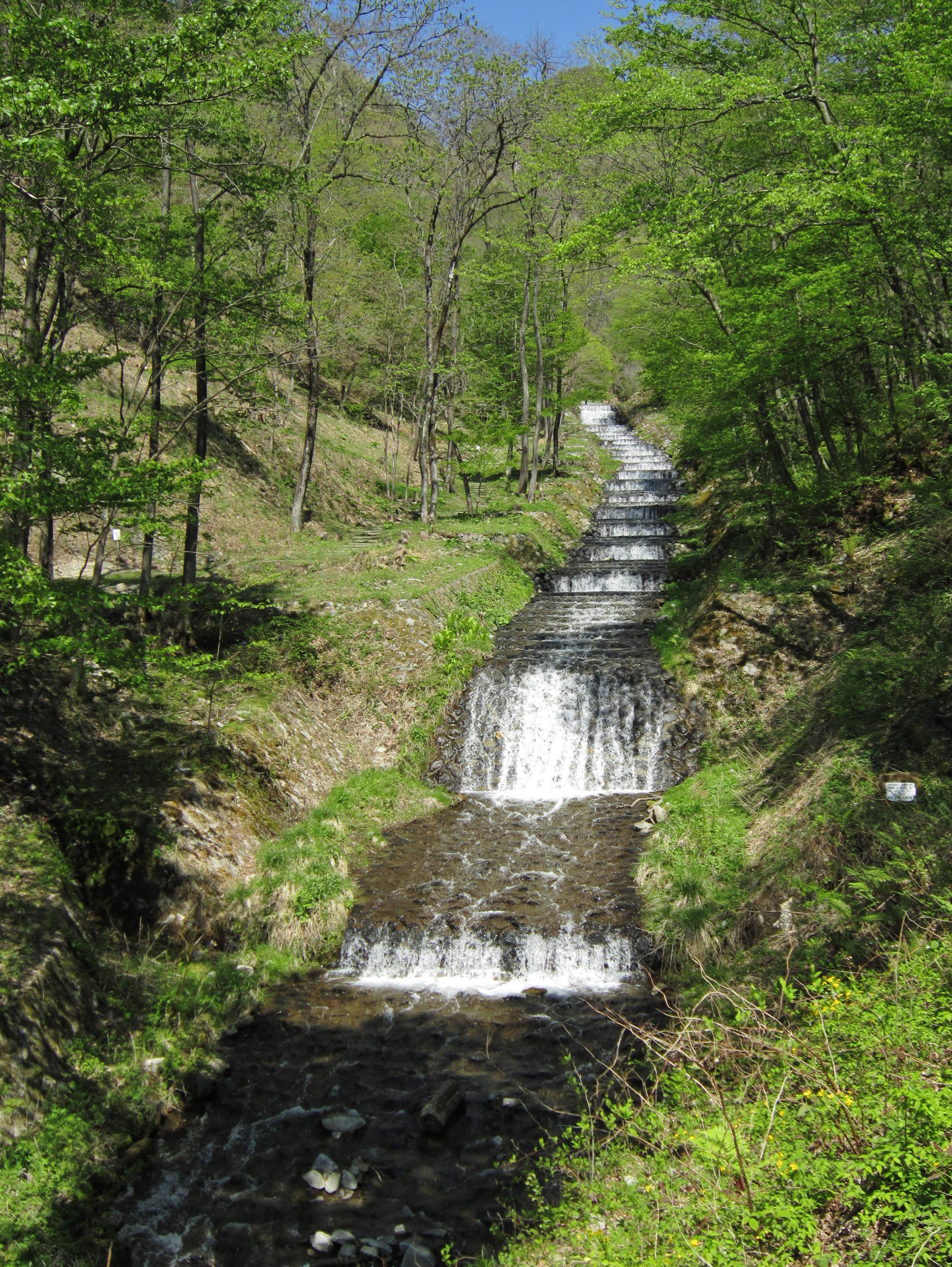
フランス式階段流路 is a waterfall (流路) formed by the 牛伏川 (Ushibuse River) as it winds through a shallow gorge near Shiojiri. Unlike a single vertical drop, the water descends over a series of stone‑lined steps, giving the cascade a “staircase” appearance that inspired its name—French‑style stair (フランス式階段). The flow creates a soft, melodic sound that blends harmoniously with the surrounding forest, making it an ideal spot for meditation, photography, and quiet contemplation.
History & Significance
The waterfall’s name originates from a historic engineering project known as the 牛伏川フランス式階段工 (Ushibuse River French‑style Staircase Works). In the early 20th century, local authorities introduced a series of stone steps to regulate water flow for irrigation and flood control. Over time, the engineered steps merged seamlessly with the natural landscape, turning a functional structure into a scenic attraction.
While the exact height of the waterfall remains unknown, its cultural value lies in the blend of traditional Japanese water management and Western engineering influence—a rare testament to Japan’s period of modernization. The site is listed on the Japanese Wikipedia page for the project, offering a glimpse into the region’s historical relationship with water resources.
Why It Matters
- Ecological Harmony – The stair‑like cascade supports a diverse micro‑habitat for mosses, ferns, and small aquatic insects.
- Cultural Fusion – It showcases a unique blend of French engineering concepts adapted to Japanese terrain.
- Off‑the‑Radar Destination – With limited tourist traffic, visitors can enjoy an intimate connection with nature, far from the crowds of more famous waterfalls.
3. How to Get There
By Train
- Tokyo → Nagano – Take the JR Chūō Line (Rapid) from Shinjuku to Nagano Station (≈2.5 hours).
- Nagano → Shiojiri – Transfer to the JR Shinonoi Line and ride to Shiojiri Station (≈30 minutes).
By Bus
From Nagano Station, the Alpine Bus runs regular services to Shiojiri. The ride takes roughly 45 minutes and drops you off near the city center.
By Car
Rent a car in Nagano or Tokyo and follow these directions:
- From Nagano: Take the Jōshin‑etsu Expressway (E19) heading west, exit at Shiojiri‑Ishiyama Interchange. Follow local road signs toward Ushibuse River and look for the GPS coordinates 36.161429, 138.022726.
- Parking: A small public lot sits near the trailhead; it fills quickly during weekends, so early arrival is recommended.
On Foot / Trailhead
From the parking area, a well‑marked 150‑meter trail leads to the waterfall. The path is relatively flat, making it accessible for most hikers and families with children.
Pro tip: Use a smartphone GPS app and input the coordinates 36.161429, 138.022726 to pinpoint the exact location.
4. Best Time to Visit
| Season | Conditions | Why Visit |
|---|---|---|
| Spring (Mar‑May) | Mild temperatures, cherry blossoms nearby, water flow increasing from snowmelt. | Fresh greenery and vibrant blossoms create perfect photo backdrops. |
| Summer (Jun‑Aug) | Warm, occasional rain showers, higher water volume. | The waterfall is at its most lively; evenings are ideal for a cool dip in the shallow pools. |
| Autumn (Sep‑Nov) | Cool air, spectacular foliage (maples, ginkgo). | The contrast of orange‑red leaves with the white cascade is breathtaking. |
| Winter (Dec‑Feb) | Snow‑covered landscape, reduced flow, possible ice formations. | For adventurous photographers, frozen steps offer a magical, ethereal scene (access may be limited). |
Overall Recommendation: Late spring (late April to early May) and early autumn (mid‑October) provide the most comfortable weather and the most photogenic scenery.
5. What to Expect
Sensory Experience
- Sound: A gentle, rhythmic murmur as water slides over each stone step—perfect for mindfulness or background music for a picnic.
- Sight: Clear, turquoise water weaving over smooth granite steps, framed by dense evergreen trees and occasional wildflowers.
- Touch: The rocks are cool and slightly slippery; bring shoes with good grip if you plan to explore the lower pools.
Photographic Highlights
- Long‑exposure shots of the cascading water create silky ribbons of light.
- Close‑up macro of moss‑covered steps reveals intricate textures.
- Seasonal contrasts – capture the pink cherry blossoms in spring or the fiery maple leaves in autumn.
Amenities
- Restroom: A modest public toilet is located near the parking lot.
- Picnic Area: A small clearing with benches allows for a relaxed lunch.
- No entry fee – the waterfall is free to the public.
Accessibility
The short trail is wheelchair‑friendly up to the viewing platform, though the final approach to the water’s edge involves uneven stones. Families with strollers may need to carry the stroller up the final few meters.
6. Nearby Attractions
While you’re in the Shiojiri area, consider adding these nearby natural sites to your itinerary. All are within a short drive (under 6 km) and complement the waterfall experience.
| Attraction | Distance from フランス式階段流路 | Type | Quick Info |
|---|---|---|---|
| [Dam A] | 0.9 km | Dam | Small hydro‑dam offering scenic views of the reservoir. |
| [Dam B] | 1.5 km | Dam | Popular spot for bird‑watching and gentle walks. |
| [Dam C] | 1.6 km | Dam | Features a walking trail along the water’s edge. |
| [Spring D] | 2.1 km | Natural Spring | Crystal‑clear spring water; perfect for a refreshing sip. |
| [Weir E] | 5.3 km | Weir | Historic weir with interpretive signage about local water management. |
Note: Exact names and URLs for these attractions are currently limited; however, they can be easily located via local tourism maps or by asking at the Shiojiri Visitor Center.
Additional Nearby Highlights
- Shiojiri City Museum – Explore regional history, including the development of irrigation systems.
- Ushibuse River Trail – A longer hiking route that follows the river upstream, offering additional waterfalls and forest scenery.
7. Travel Tips
| Tip | Details |
|---|---|
| Start Early | Arrive before 10 am to beat any weekend crowds and secure parking. |
| Bring Layers | Mountain weather can shift quickly; a light jacket is advisable even in summer. |
| Footwear | Waterproof hiking shoes with good tread protect against slippery stones. |
| Stay Hydrated | There are no vending machines on site; carry water, especially during summer hikes. |
| Respect Nature | Keep the area clean; avoid removing rocks or plants. The waterfall’s ecosystem is delicate. |
| Photography | Use a neutral density (ND) filter for long‑exposure shots; a tripod is essential for stability. |
| Local Cuisine | After your visit, try Shiojiri’s famous soba noodles at a nearby family‑run restaurant. |
| Language | Signage is primarily in Japanese; having a translation app handy can help with directions. |
| Seasonal Closures | In heavy snow (December‑January), the trail may be closed for safety. Check local weather updates before heading out. |
| Connectivity | Mobile signal can be spotty near the waterfall; download offline maps in advance. |
Final Thought
フランス式階段流路 may not dominate travel guidebooks, but its quiet elegance, historical intrigue, and harmonious blend of nature and engineering make it a standout destination for any traveler exploring Nagano’s waterfall trail. Pack your camera, lace up your boots, and let the gentle stair‑like cascade guide you into a moment of pure Japanese serenity.
Happy travels, and may the rhythm of the falling water inspire your next adventure!