入畑ダム (Irihata Dam) – A Hidden Gem in Kitakami, Iwate, Japan
Discover the tranquil beauty, engineering marvel, and surrounding nature of 入畑ダム, a lesser‑known dam that offers a perfect day‑trip for travelers seeking off‑the‑beaten‑path experiences in Japan.
1. Introduction
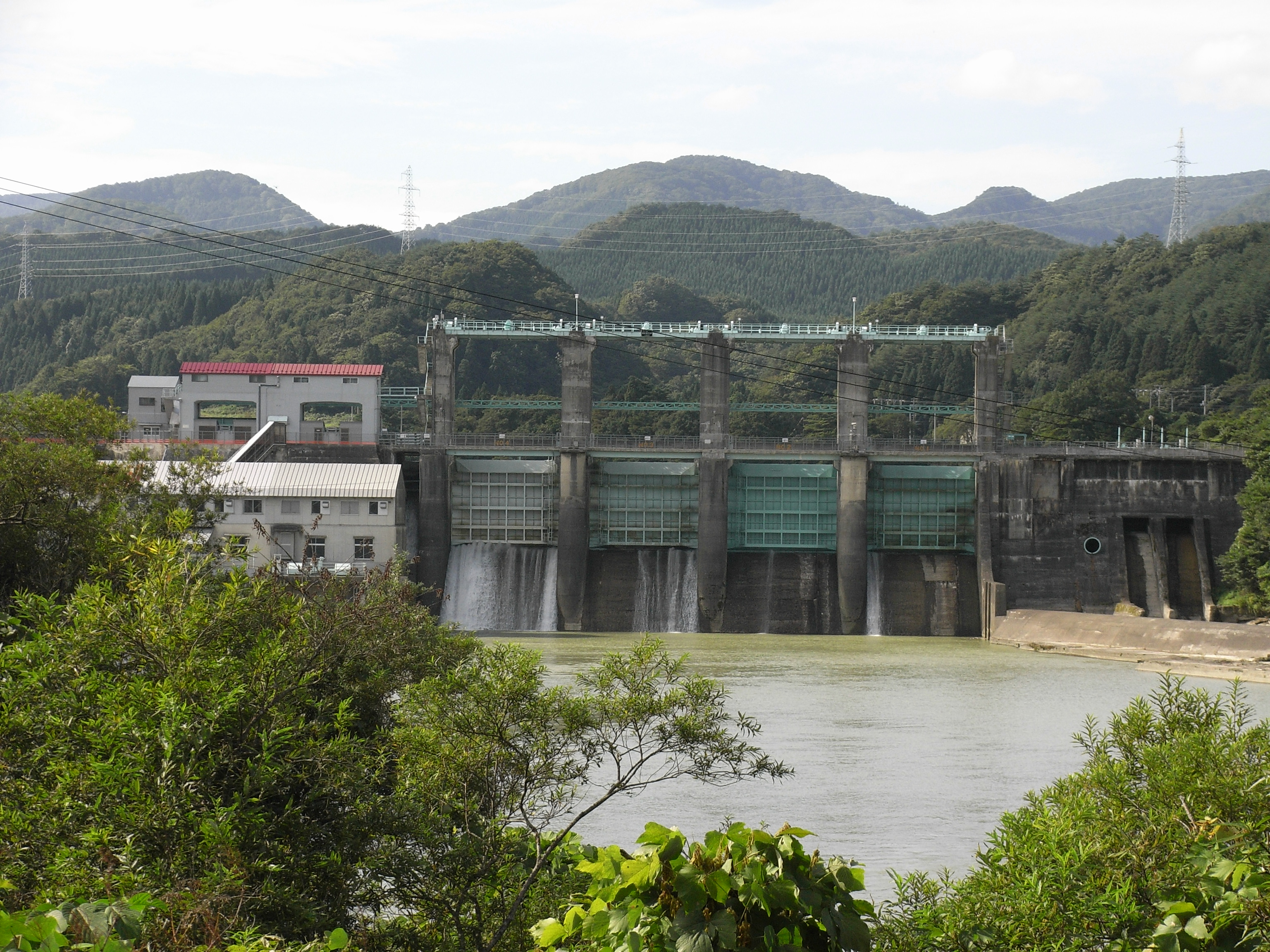
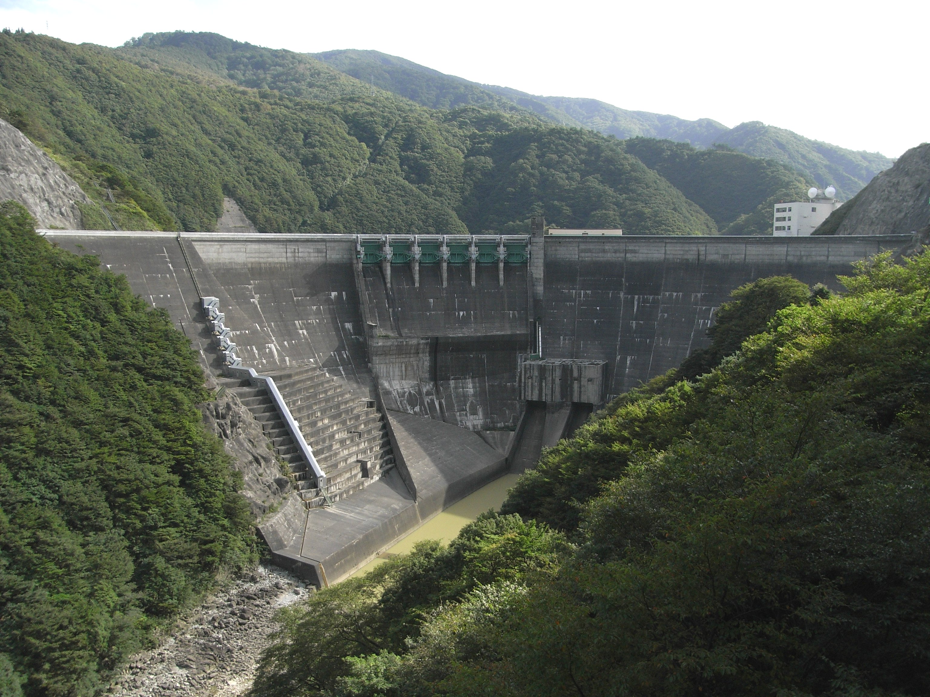
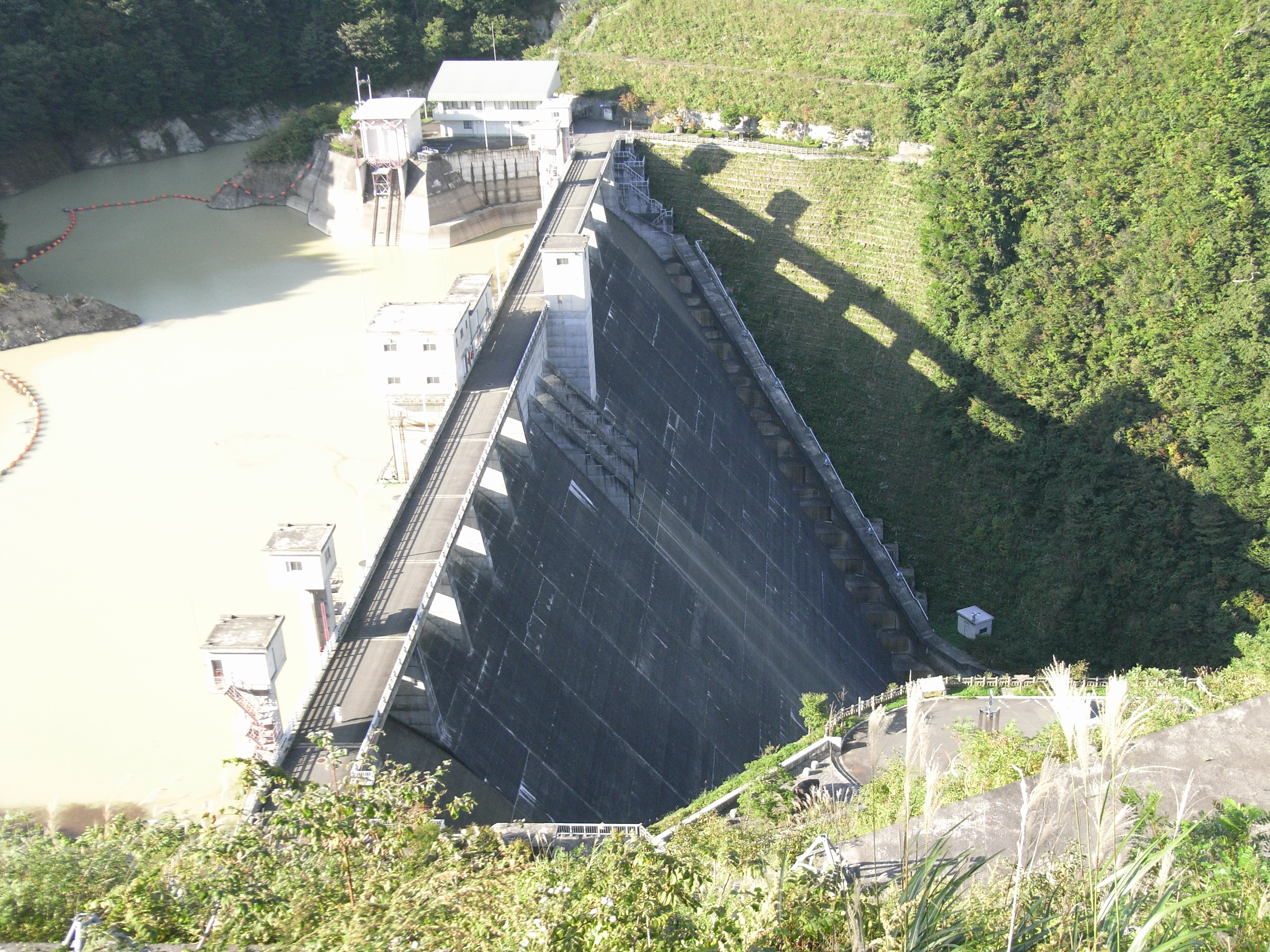
Imagine standing on a concrete wall that stretches 80 metres high, gazing out over a sapphire‑blue reservoir that mirrors the rolling hills of Iwate Prefecture. The air is crisp, the only sounds are the gentle lapping of water and the distant call of mountain birds. This is 入畑ダム (Irihata Dam) – a quiet, photogenic spot that blends impressive engineering with the serenity of rural Japan.
While Japan’s famous dams such as Kurobe or the massive Tokuyama often dominate travel guides, Irihata Dam remains a hidden treasure for those willing to venture a little farther north. Nestled in the city of Kitakami, the dam offers stunning vistas, easy access for day‑trippers, and a gateway to several nearby natural attractions. Whether you’re a photography enthusiast, a civil‑engineering fan, or simply a traveler craving a peaceful escape, Irihata Dam deserves a spot on your Iwate itinerary.
2. About 入畑ダム
Description & Specs
- Name: 入畑ダム (Irihata Dam)
- Type: Concrete gravity dam 🏗️
- Location: Kitakami, Iwate Prefecture, Japan
- Coordinates: 39.239446 N, 140.949807 E
- Height: 80 m (≈262 ft)
Built to regulate the flow of the Kitakami River basin, Irihata Dam plays a vital role in flood control, water supply, and regional irrigation. Its sleek, straight‑line crest and sturdy concrete walls showcase the practical yet elegant design typical of mid‑20th‑century Japanese dam construction.
History & Significance
Although the exact completion year isn’t listed in the public domain, the dam’s presence is documented on the Japanese Wikipedia page for Irihata Dam. The structure reflects Japan’s post‑war emphasis on infrastructure development, aimed at supporting agricultural communities and protecting downstream towns from seasonal flooding.
Beyond its functional purpose, 入畑ダム has gradually become a modest tourist attraction. Local schools organize field trips, and nature lovers frequent the reservoir’s shoreline for bird‑watching and picnics. The dam’s relatively low visitor numbers mean you can enjoy an uncrowded environment—a rarity in Japan’s popular travel spots.
3. How to Get There
By Train
- Start from Tokyo – Take the JR Tōhoku Shinkansen to Sendai (≈1.5 hours).
- Transfer to the JR Tōhoku Main Line (or the JR Kamaishi Line) and ride to Kitakami Station (≈1 hour).
From Kitakami Station
- Rental Car: The most flexible option. The dam is about 15 km north of the station, and the drive takes roughly 25 minutes via local roads.
- Local Bus: Kitakami’s municipal bus network runs limited services toward the Irihata area. Check the latest schedule at the station’s information desk.
- Taxi: A taxi ride from the station to the dam costs around ¥4,000–¥5,000, depending on traffic.
By Car (Self‑Drive)
If you’re traveling from the broader Tōhoku region, you can reach the dam via National Route 4 (the main north‑south artery of Iwate). Follow the signs for Kitakami, then look for local road markers directing you toward the “Irihata Dam” parking area.
Parking & Facilities
A small, free parking lot sits adjacent to the dam’s visitor viewpoint. Restrooms are available near the parking area, and a modest information board provides safety guidelines and a brief history of the dam.
4. Best Time to Visit
| Season | Highlights | Why Visit |
|---|---|---|
| Spring (March–May) | Cherry blossoms framing the reservoir; fresh, cool air | Ideal for photography and gentle hikes |
| Summer (June–August) | Lush green foliage; occasional fireworks from local festivals | Perfect for picnics and evening strolls |
| Autumn (September–November) | Vibrant maple and ginkgo leaves turning red, orange, and gold | Spectacular color contrast against the blue water |
| Winter (December–February) | Snow‑capped dam and frozen mist; quiet atmosphere | A serene, almost mystical landscape for early risers |
Insider tip: The dam’s water level can fluctuate seasonally. Late spring after the snowmelt offers a fuller reservoir, while early autumn often provides clearer water and calmer winds—excellent conditions for long‑exposure photography.
5. What to Expect
Scenic Views
From the main observation deck, you’ll see the dam’s 80‑meter face rising against a backdrop of rolling hills. The reservoir stretches outward, its surface shimmering under the sun. On clear days, you can spot the distant Kitakami River valley and, if you’re lucky, a glimpse of Mount Iwate on the horizon.
Walking Paths
A short, well‑maintained trail circles the reservoir, offering several photo‑stop points:
- North Lookout: Best for sunrise shots, especially in autumn.
- East Shore Picnic Area: Equipped with benches and a small gazebo—ideal for a lunch break.
- South Trail: Leads toward a modest waterfall (see “Nearby Attractions”) and provides a quieter, forested experience.
Wildlife
The reservoir’s calm waters attract waterfowl such as herons, kingfishers, and occasionally migratory ducks. Early morning bird‑watchers can hear the gentle chirps of Japanese bush warblers hidden in the surrounding trees.
Safety
While the dam is safe for visitors, swimming and boating are prohibited for security reasons. Stay behind the marked railings and follow any posted signage.
6. Nearby Attractions
After soaking in the views at 入畑ダム, expand your adventure with these nearby natural sites—each within a 10‑km radius:
| Attraction | Distance | What to See | Link |
|---|---|---|---|
| 四郎左ヱ門の滝 (Shirōzae no Taki) Waterfall | 6.2 km | A cascading waterfall nestled in a forested gorge—great for a short hike and photo ops. | Wikipedia (Japanese) |
| 石羽根ダム (Ishihane Dam) | 7.2 km | Another concrete dam offering a tranquil lakeside promenade. | Ishihane Dam (Japanese) |
| Unnamed Weir (7.4 km) | 7.4 km | Small weir with a rustic footbridge—ideal for a quiet pause. | — |
| Unnamed Weir (7.5 km) | 7.5 km | Similar to the previous weir; perfect for a brief stroll. | — |
| 湯田ダム (Yuda Dam) | 8.9 km | Larger reservoir with recreational fishing spots and a scenic walking trail. | Yuda Dam (Japanese) |
Travel tip: Combine the dam visit with a loop that includes Shirōzae no Taki and Yuda Dam for a full‑day nature itinerary. The roads are well‑marked, and each stop offers restrooms and picnic areas.
7. Travel Tips
| Tip | Details |
|---|---|
| Timing | Arrive early (7–8 am) to catch sunrise light and avoid any midday crowds, especially on weekends. |
| Parking | The lot fills up quickly during cherry‑blossom season; consider a backup parking area on the opposite side of the reservoir. |
| Food | Pack a bento or onigiri; the nearest convenience store is in Kitakami Station, about 15 km away. |
| Footwear | Wear sturdy walking shoes—some trail sections can be muddy after rain. |
| Language | Signage is primarily in Japanese; a translation app (e.g., Google Translate) helps with the information board. |
| Photography | Bring a polarizing filter to reduce glare on the water; a tripod is useful for low‑light shots of the dam at dusk. |
| Weather | Check the local forecast; fog can roll in quickly during early mornings, adding a mystical vibe but reducing visibility. |
| Respect the Environment | Carry out all trash, stay on designated paths, and avoid feeding wildlife. |
Final Thoughts
入畑ダム may not appear on every travel brochure, but that’s precisely why it feels like a secret shared among those who truly love exploring Japan’s quieter corners. From the impressive 80‑meter concrete wall to the tranquil reservoir and the surrounding forest trails, the dam offers a balanced mix of engineering wonder and natural serenity. Pair it with nearby waterfalls and other dams, and you have a compact, rewarding day‑trip that showcases the diverse beauty of Iwate Prefecture.
So load up your camera, grab a snack, and set your GPS to 39.239446, 140.949807—the gateway to a peaceful slice of Japanese countryside awaits. Safe travels!