栗駒ダム (Kurikoma Dam) – A Hidden Gem in Ichinoseki, Iwate
Discover the serene beauty of a lesser‑known dam, the surrounding waterfalls, and the authentic charm of rural Iwate.
1. Introduction
If you think Japan’s most famous sights are only skyscrapers, neon streets, or ancient temples, think again. Tucked away in the lush hills of Ichinoseki, Iwate, the 栗駒ダム (Kurikoma Dam) offers a peaceful retreat for travelers who crave nature, photography, and a slice of local life. With crystal‑clear waters reflecting the surrounding forest, the dam is a perfect backdrop for sunrise hikes, picnics, and exploring a cluster of spectacular waterfalls just a few kilometers away. Whether you’re a seasoned dam‑enthusiast, a waterfall chaser, or simply looking for a quiet spot off the beaten path, Kurikoma Dam should be on your Iwate itinerary.
2. About 栗駒ダム
- Location: 38.907479 N, 140.918782 E, Ichinoseki City, Iwate Prefecture, Japan
- Type: Multipurpose dam (primarily water resource management and flood control)
- Construction: The dam is part of Iwate’s extensive water‑management network, built to support agricultural irrigation, municipal water supply, and regional flood mitigation.
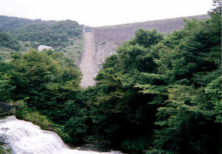
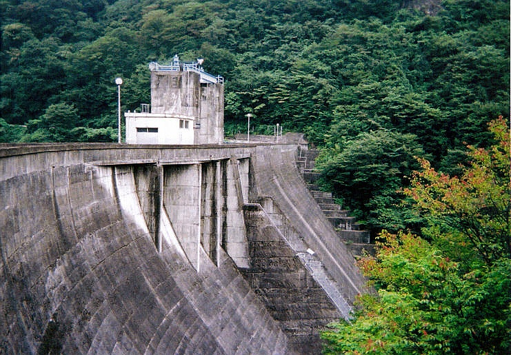
While the exact height and altitude are not publicly disclosed, the dam’s design blends seamlessly with the surrounding forested hills. Its reservoir, often calm and mirror‑like, creates a natural amphitheater for sunrise and sunset photography. The dam’s modest scale compared to mega‑structures like the Kurobe Dam gives visitors a more intimate experience—no crowds, just the gentle rustle of leaves and the occasional splash of fish.
Why it matters:
Kurikoma Dam plays a vital role in sustaining the local community’s water needs and protecting downstream areas from seasonal flooding. For travelers, it represents a living piece of Japan’s modern engineering that coexists with pristine nature—a reminder that the country’s infrastructure often doubles as a scenic attraction.
3. How to Get There
From Major Cities
| Starting Point | Transportation | Approx. Time |
|---|---|---|
| Tokyo | Shinkansen to Ichinoseki Station (Tōhoku Shinkansen) → Rent a car or take a local bus | 2.5 h (Shinkansen) + 30‑45 min (car/bus) |
| Sendai | JR Tōhoku Line to Ichinoseki Station → Local bus or taxi | 1 h 30 min (train) + 30 min (bus/taxi) |
| Morioka | JR Tōhoku Line to Ichinoseki → Taxi | 1 h (train) + 20 min (taxi) |
By Car
- From Ichinoseki Station: Take National Route 46 eastward, then turn onto Prefectural Road 71 (川原町道) following the signs for “栗駒ダム”. The drive is about 15 km and takes roughly 25 minutes.
- Parking: A small free parking lot sits near the dam’s visitor area. Space can fill up on weekends, so arrive early if possible.
By Bus
- Local Bus “Ichinoseki‑Kurikoma Line” (operated by Iwate Kotsu) departs from Ichinoseki Station every hour between 8 am‑5 pm. The ride to the dam stop is ~40 minutes. Check the latest timetable on the Iwate Kotsu website before you travel.
Getting Around
The dam area is best explored on foot. A short, well‑marked trail leads from the parking lot to the viewing platform, a picnic area, and the riverbank. Comfortable walking shoes and a light rain jacket are recommended—mountain weather can change quickly.
4. Best Time to Visit
| Season | Highlights | Tips |
|---|---|---|
| Spring (Mar‑May) | Cherry blossoms may fringe the reservoir; fresh green foliage creates vivid contrast. | Early mornings (6‑8 am) offer the clearest light for photos. |
| Summer (Jun‑Aug) | Lush forest canopy, occasional mist over the water; perfect for cooling picnics. | Bring sunscreen and insect repellent; afternoon thunderstorms are common. |
| Autumn (Sep‑Nov) | Brilliant reds, oranges, and yellows reflect on the dam’s surface—ideal for landscape photography. | Mid‑October is peak foliage; expect cooler temperatures, so wear layers. |
| Winter (Dec‑Feb) | Snow‑capped hills and a quiet, serene atmosphere; the dam may develop a thin ice crust, creating unique textures. | Roads can be slippery; a vehicle with winter tires is advisable. |
Overall, late October to early November is the most photographed period, thanks to the vivid autumn colors. However, each season offers its own charm, and the dam’s relative seclusion means you’ll rarely encounter large crowds.
5. What to Expect
Scenic Views
- Panoramic Reservoir: The water stretches like a glass pane, reflecting the surrounding forest and sky.
- Viewing Platform: A modest wooden deck provides unobstructed views of the dam wall and the downstream river.
- Picnic Area: Benches and a small shelter invite you to enjoy a bento lunch while listening to the gentle flow of water.
Wildlife
- Birdwatching: You may spot kingfishers, wagtails, and occasional raptors soaring above the reservoir.
- Aquatic Life: Small fish dart near the shoreline; if you’re lucky, you might glimpse a koi‑like carp gliding beneath the surface.
Atmosphere
The site feels like a “living museum.” While the dam’s concrete structure is functional, it is framed by towering trees, moss‑covered rocks, and the occasional distant waterfall’s roar. The combination of engineering and nature creates a tranquil setting ideal for meditation, sketching, or simply unplugging from the digital world.
6. Nearby Attractions
The area around Kurikoma Dam is a waterfall lover’s paradise. All attractions are within a 10 km radius, making a day‑trip itinerary easy to plan.
| Attraction | Distance from Dam | Type | Why Visit? |
|---|---|---|---|
| 行者滝 (Gyōja Waterfall) | 4.6 km | Waterfall | A 20‑minute hike leads to a 30 m cascade surrounded by mossy rocks. |
| 荒砥沢ダム (Aratōzawa Dam) | 5.8 km | Dam | Another small dam offering a different perspective on Iwate’s water management. |
| Mado Falls (窓の滝) | 6.9 km | Waterfall | Known for its “window‑like” rock formation that frames the falling water. |
| めっこの滝 (Mekko Waterfall) | 7.9 km | Waterfall | A hidden gem with a gentle, multi‑tiered flow—great for a quiet pause. |
| 同間の滝 (カッパの滝, Kappa Waterfall) | 8.4 km | Waterfall | Legend says a kappa (mythical water sprite) dwells here; the waterfall’s mist creates a mystical ambiance. |
Quick Links:
- 行者滝 (Gyōja Waterfall)
- 荒砥沢ダム (Aratōzawa Dam)
- Mado Falls
- めっこの滝 (Mekko Waterfall)
- 同間の滝 (カッパの滝)
Suggested Day‑Trip Route:
1. Start at 栗駒ダム for sunrise photos.
2. Head north to 行者滝 (short hike).
3. Continue east to 荒砥沢ダム for a quick dam comparison.
4. Lunch at a local farm café in Ichinoseki.
5. In the afternoon, visit Mado Falls and めっこの滝, ending with 同間の滝 for a sunset mist experience.
7. Travel Tips
- Timing: Arrive early (7 am‑8 am) in spring and autumn to catch the best light and avoid any small crowds.
- Footwear: Sturdy, waterproof shoes are essential for the uneven forest trails and waterfall paths.
- Food: Bring a packed lunch. While there are small convenience stores in Ichinoseki, the dam area has no vending facilities.
- Language: Signage around the dam is primarily Japanese. Having a translation app or a simple phrasebook helps when asking locals for directions.
- Connectivity: Mobile reception can be spotty near the reservoir; consider downloading offline maps (Google Maps offline area for the coordinates 38.907479, 140.918782).
- Respect Nature: Stay on marked trails, avoid feeding wildlife, and take any trash with you. The area’s pristine condition depends on responsible visitor behavior.
- Photography Gear: A wide‑angle lens captures the expansive water view, while a telephoto lens is handy for distant waterfall details. A tripod is useful for low‑light sunrise or twilight shots.
- Safety: During heavy rain (June‑July), the river’s flow can rise quickly. Check local weather forecasts and heed any posted warnings.
Wrap‑Up
栗駒ダム may not appear on every Japan travel guide, but its tranquil waters, surrounding forest, and proximity to several stunning waterfalls make it a hidden treasure for the curious explorer. Whether you’re chasing the perfect autumn reflection, seeking a quiet spot to unwind, or planning a waterfall‑hopping adventure in Iwate, the dam offers a serene base camp that blends engineering, nature, and Japanese hospitality. Pack your camera, lace up your hiking boots, and let the gentle ripple of Kurikoma Dam guide you into the heart of rural Iwate.
Happy travels!