鮎屋川ダム (Ayagawa Dam) – A Hidden Gem in Sumoto, Hyogo, Japan
Explore the serene landscape, crisp mountain air, and nearby waterfalls that make this dam a perfect off‑the‑beaten‑path destination for nature lovers and road‑trip enthusiasts.
1. Introduction
If you’ve ever driven along the coastal roads of Awaji Island and felt a sudden urge to step off the highway into a quiet, green valley, you’re already halfway to discovering 鮎屋川ダム. Nestled in the town of Sumoto, Hyogo Prefecture, this modest dam may not have the towering fame of Japan’s mega‑hydropower projects, but it offers a tranquil setting that captures the essence of rural Japan. From the gentle ripple of the reservoir to the mist‑kissed 鮎屋の滝 just a stone’s throw away, the area is a photographer’s dream and a peaceful retreat for hikers, cyclists, and families alike.
In this guide, we’ll walk you through everything you need to know to make the most of a visit to 鮎屋川ダム—how to get there, when to go, what you’ll see, and the surrounding attractions that round out a perfect day trip on Awaji Island.
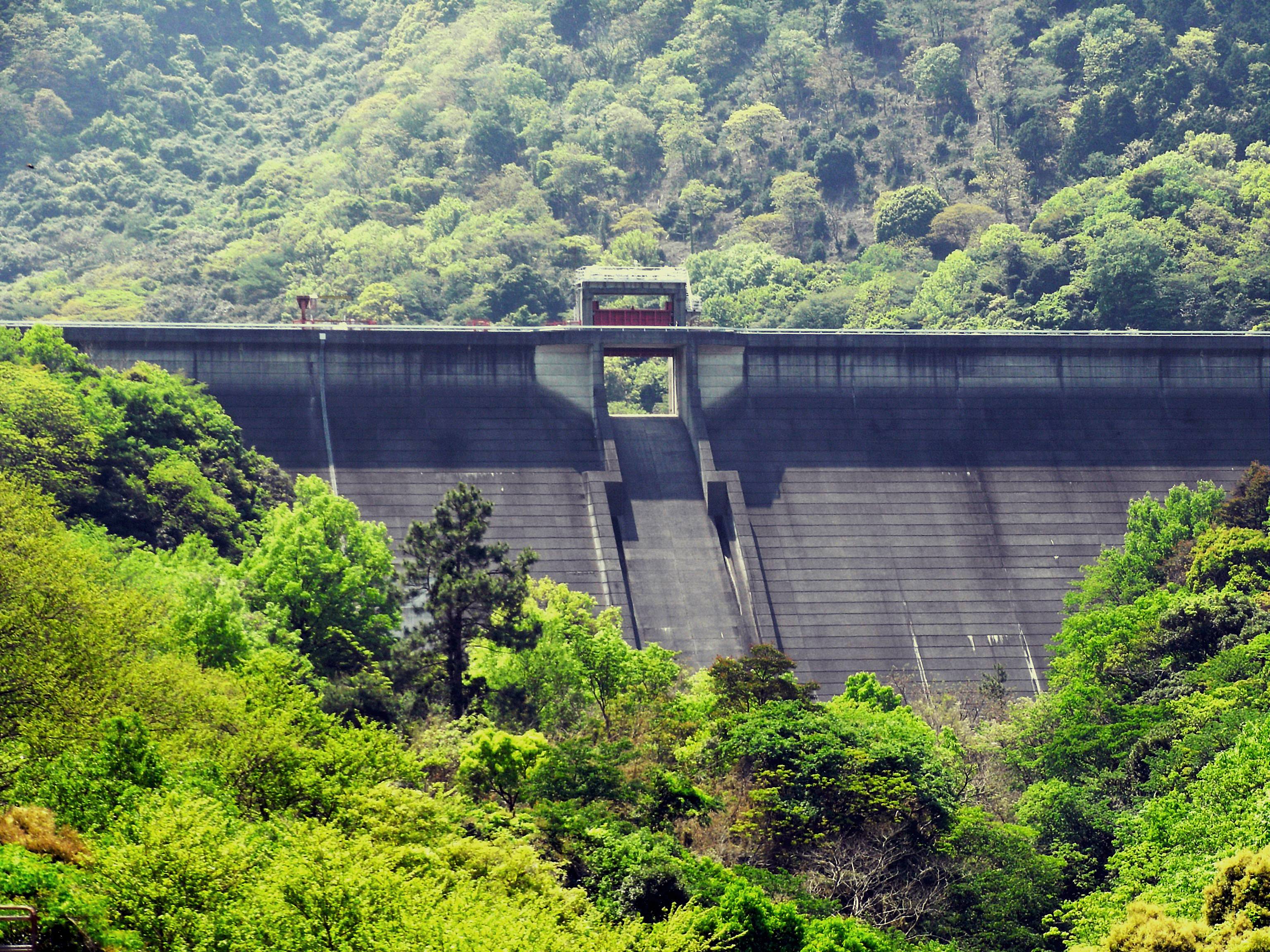
2. About 鮎屋川ダム
A Brief Description
- Name: 鮎屋川ダム (Ayagawa Dam)
- Type: Dam (purpose primarily for water management and local irrigation)
- Location: Sumoto, Hyogo Prefecture, Japan
- Coordinates: 34.297294 N, 134.843923 E
The dam sits amid a gently rolling forested basin, creating a calm reservoir that mirrors the surrounding hills. While official sources list the height and altitude as “unknown,” the structure blends seamlessly into the landscape, emphasizing function over spectacle.
History & Significance
According to the Japanese Wikipedia entry for 鮎屋川ダム, the dam was constructed as part of regional water‑resource development initiatives aimed at supporting agriculture and protecting downstream communities from flood risks. Though it does not host a visitor center or large‑scale recreational facilities, its presence is vital for the local farming community that cultivates rice paddies and vegetable fields in the Sumoto plain.
In recent years, the dam’s reservoir has become an informal gathering spot for locals who enjoy picnicking, bird‑watching, and seasonal photography. The calm water surface often reflects the vibrant colors of autumn foliage, making it a seasonal highlight for landscape photographers.
3. How to Get There
By Car
- From Kobe/Osaka: Take the Hanshin Expressway (E28) toward Awaji Island, cross the Akashi Kaikyō Bridge, and follow signs for National Route 28 to Sumoto. From the Sumoto interchange, turn onto Prefectural Road 31 (the road that leads directly to the dam).
- Parking: A small free parking lot is located near the dam’s access road. Expect a short walk (≈5 minutes) from the lot to the reservoir’s edge.
By Public Transport
- Train: Board the JR Kobe Line to Himeji Station, then transfer to the JR San’yō Main Line to Awaji Station (the nearest JR station on Awaji Island).
- Bus: From Awaji Station, catch the Awaji Kōtsū bus bound for Sumoto (Route 2). Get off at the “Sumoto‑Kōen” stop; the dam is a 10‑minute walk northward along a well‑marked trail.
Tip: Bus schedules are less frequent on weekends and holidays, so plan ahead or consider renting a car for maximum flexibility.
By Bicycle
Awaji Island is renowned for its coastal cycling routes. The Awaji Island Cycling Road (≈120 km loop) passes near Sumoto, and a side‑road branch leads directly to 鮎屋川ダム. Bring a lock and a water bottle—there are shaded rest spots near the dam but limited facilities.
4. Best Time to Visit
| Season | Highlights | Why It’s Ideal |
|---|---|---|
| Spring (Mar‑May) | Fresh green foliage, cherry blossoms on nearby hills, clear water | Mild temperatures (12‑20 °C) make walking comfortable; early morning mist adds a mystical feel. |
| Summer (Jun‑Aug) | Lush canopy, occasional fireflies at dusk | Warm days (25‑30 °C) are perfect for a picnic by the reservoir; however, be prepared for occasional rain. |
| Autumn (Sep‑Nov) | Brilliant red‑orange maple leaves, reflective water surface | Cooler air (13‑19 °C) and vibrant colors create postcard‑worthy scenery; ideal for photography. |
| Winter (Dec‑Feb) | Snow‑capped hills (rare), quiet atmosphere | Fewer visitors, crisp air, and occasional frost on the water’s edge; perfect for a peaceful retreat. |
Overall recommendation: Late October to early November offers the most striking visual contrast between the calm reservoir and the fiery foliage of surrounding trees.
5. What to Expect
The Landscape
Approaching the dam, you’ll first notice a modest concrete spillway that gently releases water into the downstream river. The reservoir itself is relatively small—more of a pond‑like lake—but its still surface acts like a natural mirror, especially after a light rain. The surrounding forest consists mainly of Japanese cedar (sugi) and Japanese cypress (hinoki), interspersed with occasional maple trees that turn brilliant colors in autumn.
Activities
- Scenic Walks: A short, well‑maintained trail circles the reservoir, offering multiple viewpoints. Benches are placed at strategic spots for rest and photography.
- Picnicking: Bring a bento box and enjoy a lakeside meal. While there are no built‑in grills, the open space allows for portable stoves.
- Bird‑watching: The area attracts species such as the Japanese bush warbler (uguisu) and various waterfowl. Bring binoculars for a better view.
- Photography: The dam’s calm water and surrounding foliage provide excellent foregrounds for sunrise and sunset shots.
Facilities
- Restrooms: A basic public restroom is located near the parking area.
- Information Board: A small sign explains the dam’s purpose and offers safety reminders (e.g., no swimming, stay behind the railings).
6. Nearby Attractions
A short stroll from 鮎屋川ダム reveals several other points of interest that can easily be combined into a half‑day itinerary.
| Attraction | Distance from Dam | Highlights | Link |
|---|---|---|---|
| (Unnamed) Dam | 0 km (same site) | The primary structure of 鮎屋川ダム itself | — |
| (Unnamed) Dam | 0.5 km | Small auxiliary spillway; good for a quick photo stop | — |
| 鮎屋の滝 (Ayagawa Waterfall) | 0.5 km | A 10‑meter cascade surrounded by mossy rocks; perfect for a short hike | 鮎屋の滝 |
| (Unnamed) Dam | 1.1 km | Another minor dam in the watershed, offering a different angle of the river | — |
| (Unnamed) Dam | 1.2 km | Slightly higher elevation, providing a panoramic view of the valley | — |
Pro tip: The trail that links the dam to 鮎屋の滝 is well‑marked and takes about 10‑15 minutes each way. It’s an excellent option for families with children or for anyone looking for a gentle hike.
7. Travel Tips
- Check Weather Forecasts – The dam area can become slippery after rain. Early autumn mornings are often clear, but sudden showers are common in the rainy season (June‑July).
- Bring Cash – There are no vending machines or shops on site. If you plan a picnic, purchase supplies in Sumoto before heading out.
- Respect the Environment – The reservoir is a functional water source. Dispose of trash in the provided bins and avoid feeding wildlife.
- Dress in Layers – Temperatures can shift quickly, especially near the water. A light jacket or windbreaker is advisable even in summer evenings.
- Photography Gear – A wide‑angle lens captures the expansive water view, while a telephoto lens is useful for bird‑watching. A tripod helps in low‑light conditions during sunrise or sunset.
- Timing for Crowds – Weekdays in the early morning (7‑9 am) are the quietest. Weekends attract local families, especially during school holidays.
- Accessibility – The main trail is relatively flat, but there are a few steps near the waterfall. If you have limited mobility, stick to the reservoir’s perimeter path.
Wrap‑Up
Whether you’re a seasoned traveler exploring Awaji Island’s coastal charms or a local looking for a peaceful spot to unwind, 鮎屋川ダム offers a subtle yet rewarding experience. Its modest size belies the natural beauty that surrounds it—crystal‑clear water, whispering forests, and the nearby cascade of 鮎屋の滝. Pair a visit with a leisurely drive along the island’s scenic roads, and you’ll discover why this hidden dam is slowly becoming a favorite secret among Japan’s nature enthusiasts.
Pack a snack, bring your camera, and set your GPS to 34.297294, 134.843923—the serenity of 鮎屋川ダム awaits. Safe travels!