美生ダム (Bisei Dam) – A Hidden Hokkaido Gem Worth the Journey
Explore the tranquil beauty of Obihiro’s countryside, discover the engineering marvel of 美生ダム, and uncover nearby natural wonders that make this part of Hokkaido a must‑visit for travelers seeking off‑the‑beaten‑path experiences.
1. Introduction
When you think of Hokkaido, towering volcanoes, lavender fields, and world‑class ski resorts often come to mind. Yet, tucked away in the rolling plains of Obihiro lies a lesser‑known treasure that blends nature, engineering, and local culture: 美生ダム (Bisei Dam). This modest dam may not boast the height of Japan’s massive hydro‑structures, but its serene reservoir, surrounding farmlands, and peaceful atmosphere create a perfect backdrop for a day‑trip or a quiet afternoon of contemplation. Whether you’re a photography enthusiast, a road‑trip adventurer, or simply curious about Japan’s water‑management heritage, 美生ダム offers an authentic slice of Hokkaido life that few guidebooks highlight.
2. About 美生ダム
Description & History
- Location: Obihiro, Tokachi Subprefecture, Hokkaido, Japan
- Coordinates: 42.805467 N, 142.851477 E
- Type: Multipurpose dam (primarily for irrigation and flood control)
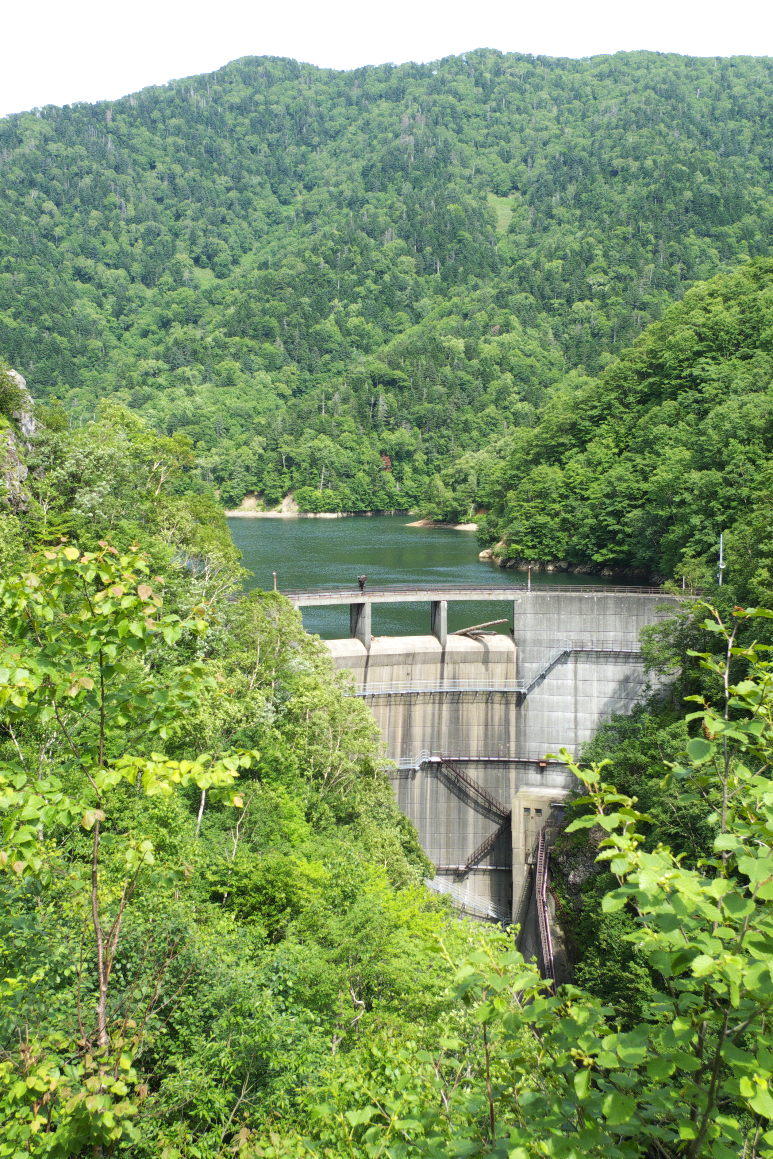
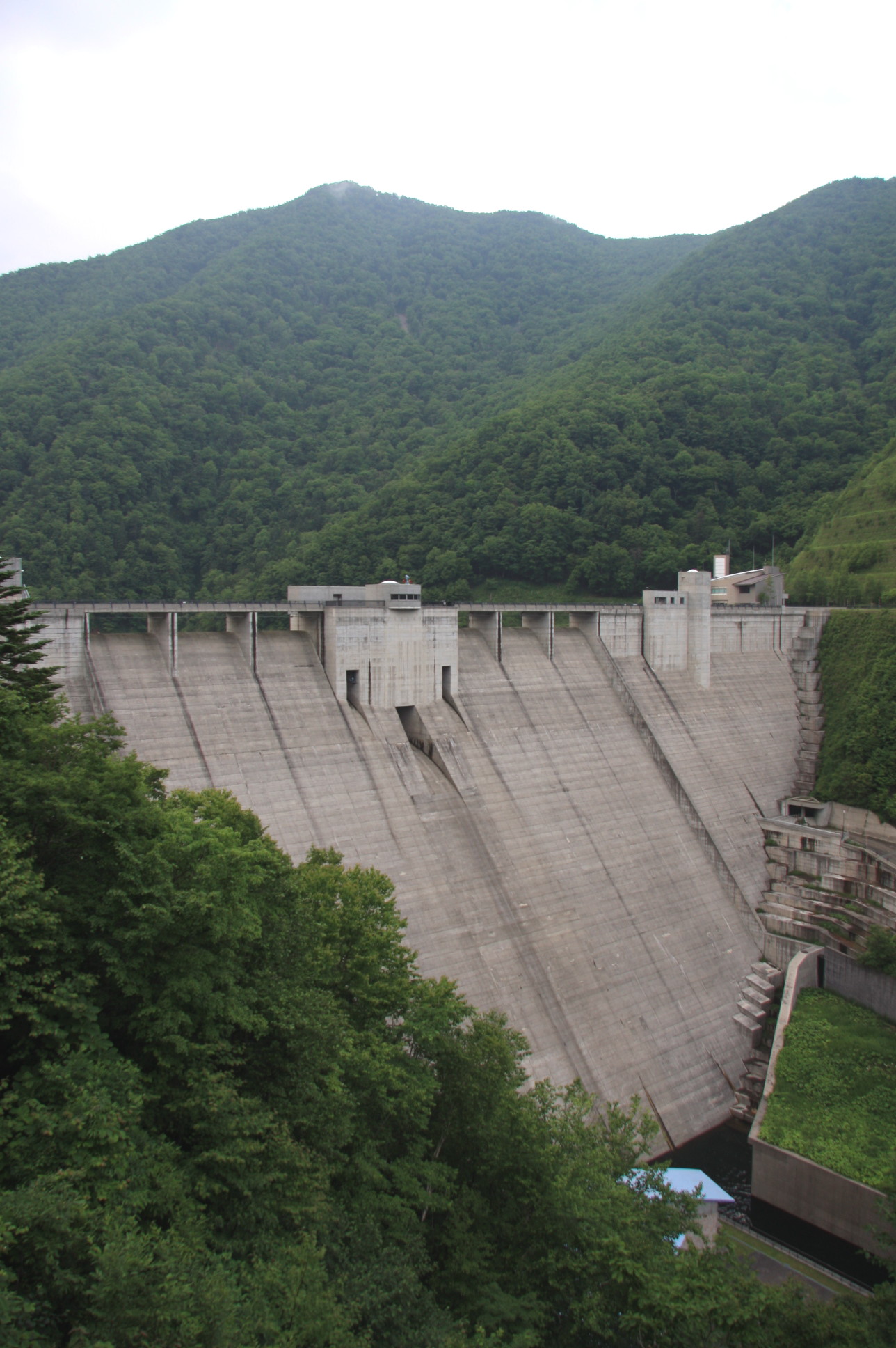
Built to support the fertile Tokachi Plain—one of Hokkaido’s most productive agricultural zones—美生ダム plays a crucial role in regulating water for rice paddies, dairy farms, and vegetable fields that surround Obihiro. While official records list the dam’s exact height and altitude as “unknown,” its presence is evident in the gentle curve of the reservoir that mirrors the expansive sky of central Hokkaido.
The dam’s name, 美生 (pronounced Bisei), combines the kanji for “beauty” (美) and “life” (生), reflecting the community’s hope that the structure would nurture both the land and its people. Since its completion, the dam has become a modest yet vital piece of infrastructure, quietly supporting the region’s reputation as Japan’s “breadbasket.”
Significance
- Agricultural Backbone: The Tokachi Plain supplies a large portion of Hokkaido’s rice, wheat, and dairy products. Reliable water storage at 美生ダム helps mitigate the risk of drought during the hot summer months.
- Environmental Balance: By regulating river flow, the dam helps preserve downstream ecosystems, supporting fish habitats and wetland areas that attract migratory birds.
- Cultural Touchstone: Local festivals occasionally incorporate the dam’s reservoir as a scenic backdrop, and the surrounding fields host seasonal harvest events that invite visitors to experience authentic Hokkaido hospitality.
For a deeper dive into the dam’s background, you can explore the Japanese Wikipedia entry: 美生ダム (Wikipedia).
3. How to Get There
By Public Transportation
- Train to Obihiro – Take the JR Hokkaido Nemuro Main Line from Sapporo to Obihiro Station (approx. 2.5 hours).
- Bus to the Dam – From Obihiro Station, board the local bus heading toward the Tokachi Plain (look for routes labeled “Tokachi‑Nishi” or “農業バス”). The bus stops near the dam’s access road; ask the driver for “美生ダム” as a reference point.
Tip: Bus schedules are limited in the off‑season (November–March). Check the latest timetable on the Obihiro City transportation website before you travel.
By Car
Renting a car offers the most flexibility, especially if you plan to explore nearby attractions.
- From Obihiro Station: Take National Route 236 eastward, then turn onto Prefectural Road 31 (川上道). Follow the signs for “美生ダム” – the road is well‑marked and the GPS coordinates (42.805467, 142.851477) will guide you directly to the parking area.
- Travel Time: Approximately 30 minutes (≈25 km).
By Bicycle
For the adventurous, the Tokachi Plain’s flat terrain makes cycling a pleasant option. Bike rental shops near Obihiro Station provide mountain or hybrid bikes, and the ride to 美生ダム takes roughly 1.5 hours, allowing you to stop at roadside farms and enjoy the countryside at a leisurely pace.
4. Best Time to Visit
| Season | Highlights | Why Visit |
|---|---|---|
| Spring (April‑May) | Cherry blossoms along the riverbanks, fresh green fields | Mild temperatures (10‑15 °C) and blooming scenery make for excellent photography. |
| Summer (June‑August) | Lush reservoir, vibrant agricultural activity | Ideal for picnics; the dam’s water level is high, creating reflective surfaces for sunrise shots. |
| Autumn (September‑October) | Golden rice paddies, crisp air, occasional mist over the lake | The “golden hour” is spectacular; harvest festivals may be occurring nearby. |
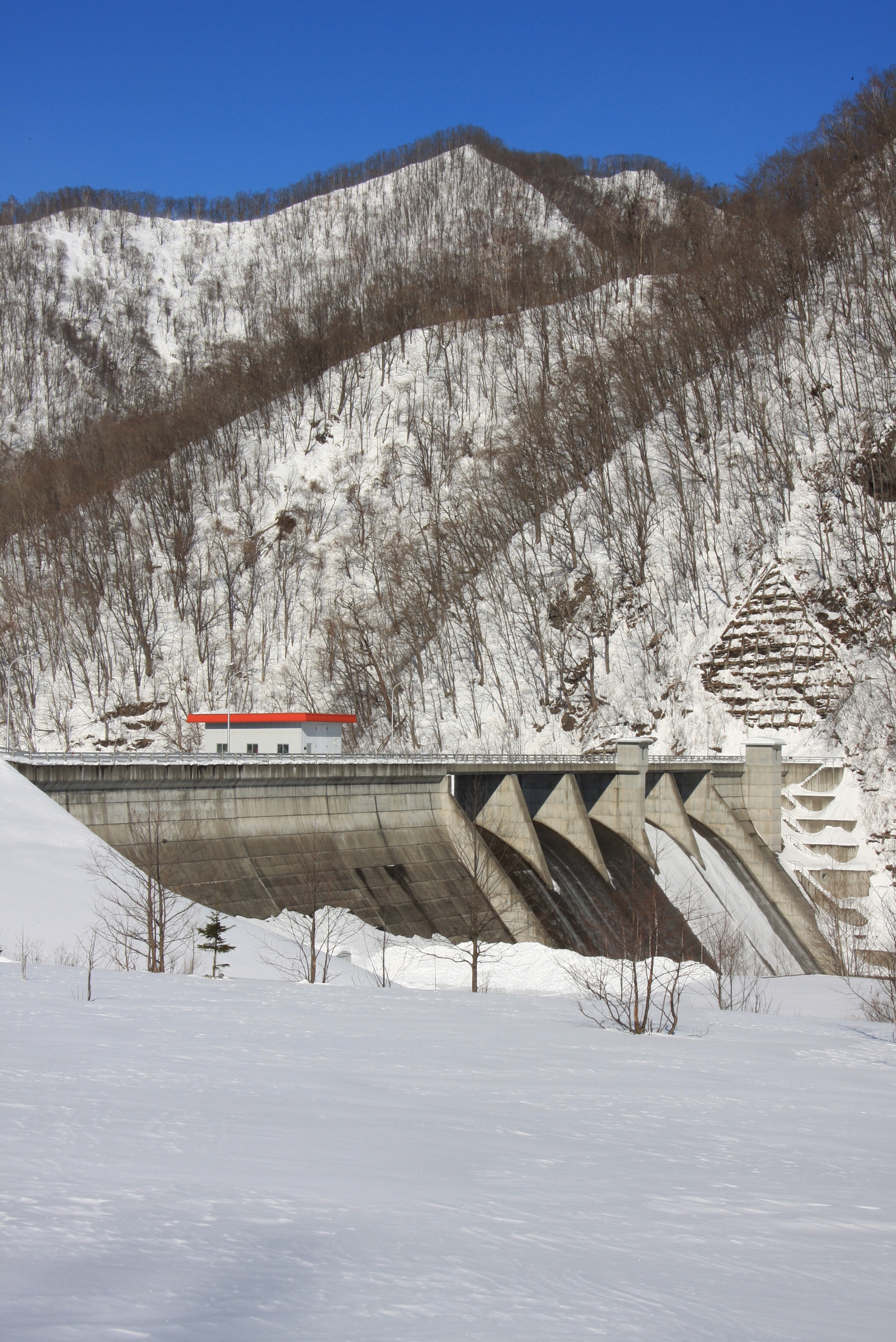
| Winter (November‑March) | Snow‑covered fields, tranquil silence | For those who love winter landscapes, the dam’s icy edges create a magical, almost otherworldly view. |
Recommendation: Late May to early October offers the most comfortable weather and the fullest water levels, ensuring both scenic beauty and safe access to walking paths.
5. What to Expect
Arriving at 美生ダム, you’ll be greeted by a modest parking lot, a short paved walkway, and a gently sloping embankment that leads to a viewpoint overlooking the reservoir. The water is typically calm, mirroring the sky and the surrounding fields—a perfect setting for reflective photography or a quiet moment of contemplation.
- Scenic Walks: A 1‑kilometer trail circles part of the reservoir, offering multiple angles of the dam structure, the flowing river, and the distant Tokachi hills.
- Birdwatching: Early mornings attract waterfowl, sandpipers, and occasionally migratory swans that pause to rest on the shallow edges. Bring binoculars if you’re an avid birdwatcher.
- Local Interaction: Small farms line the perimeter. Friendly farmers often welcome visitors who wish to learn about Hokkaido’s dairy and rice production. Some may offer fresh milk or seasonal fruit for a modest price.
- Photography Hotspots: The best shots are taken from the western viewpoint at sunrise (the sun rises over the mountains) and from the eastern bank at sunset (the light reflects off the water).
Because the dam is primarily functional rather than a tourist attraction, facilities are minimal—there are no cafés or souvenir shops on site. However, a portable picnic and a reusable water bottle will keep you comfortable.
6. Nearby Attractions
Exploring the area around 美生ダム reveals several natural and engineered points of interest, each within a short drive.
| Attraction | Type | Distance from 美生ダム | Highlights |
|---|---|---|---|
| Unnamed Weir | Weir | 9.3 km | Small water diversion structure; great for a quick stop and photo. |
| Unnamed Dam | Dam | 9.3 km | Similar in scale to 美生ダム; offers a comparative view of Hokkaido’s water management. |
| 七ッ沼カール (Nanatsunuma Karl) Spring | Spring | 15.0 km | Crystal‑clear spring water, surrounded by mossy rocks; a peaceful spot for meditation. |
| Unnamed Weir (Second) | Weir | 19.9 km | Scenic river bend; ideal for short hikes. |
| 奥沙流ダム (Okusaru Dam) | Dam | 19.9 km | Larger reservoir with fishing opportunities; popular among local anglers. |
Quick Links: While some attractions lack dedicated web pages, you can locate them on Google Maps using the coordinates provided above. Searching “七ッ沼カール” will bring up the spring’s exact spot.
7. Travel Tips
- Check Water Levels: Seasonal fluctuations affect the reservoir’s appearance. The Tokachi Agricultural Office posts monthly water‑level updates on its website.
- Dress in Layers: Hokkaido’s weather can change quickly, especially near water bodies. A light windbreaker and a warm sweater are advisable even in summer evenings.
- Bring Cash: Rural shops and farms may not accept credit cards. A small amount of yen will cover snacks, souvenirs, or a fresh milk bottle.
- Respect Private Property: Some farms bordering the dam are private. Stay on marked paths and avoid trespassing.
- Photography Etiquette: If you’re photographing farmers or livestock, ask for permission first. Hokkaido residents value courtesy and will often smile for a respectful portrait.
- Parking Fees: The parking lot is free for up to 2 hours; beyond that, a modest fee of ¥200 per hour applies.
- Language: Signage is primarily in Japanese. Having a translation app or a small phrasebook (e.g., “トイレはどこですか?” – “Where is the restroom?”) can be helpful.
- Stay Connected: Mobile coverage is reliable in Obihiro, but can be spotty near the dam. Download offline maps before you set out.
Final Thought
美生ダム may not headline Hokkaido’s travel itineraries, but its quiet charm, agricultural significance, and surrounding natural beauty make it a rewarding destination for those willing to venture beyond the usual tourist routes. Combine a visit with nearby springs, lesser‑known weirs, and the larger 奥沙流ダム, and you’ll experience a slice of authentic Hokkaido life that resonates long after you leave. Pack a camera, a picnic, and a sense of curiosity—Bisei Dam awaits.
Happy travels, and may your journey through the heart of Hokkaido be as refreshing as the waters of 美生ダム!